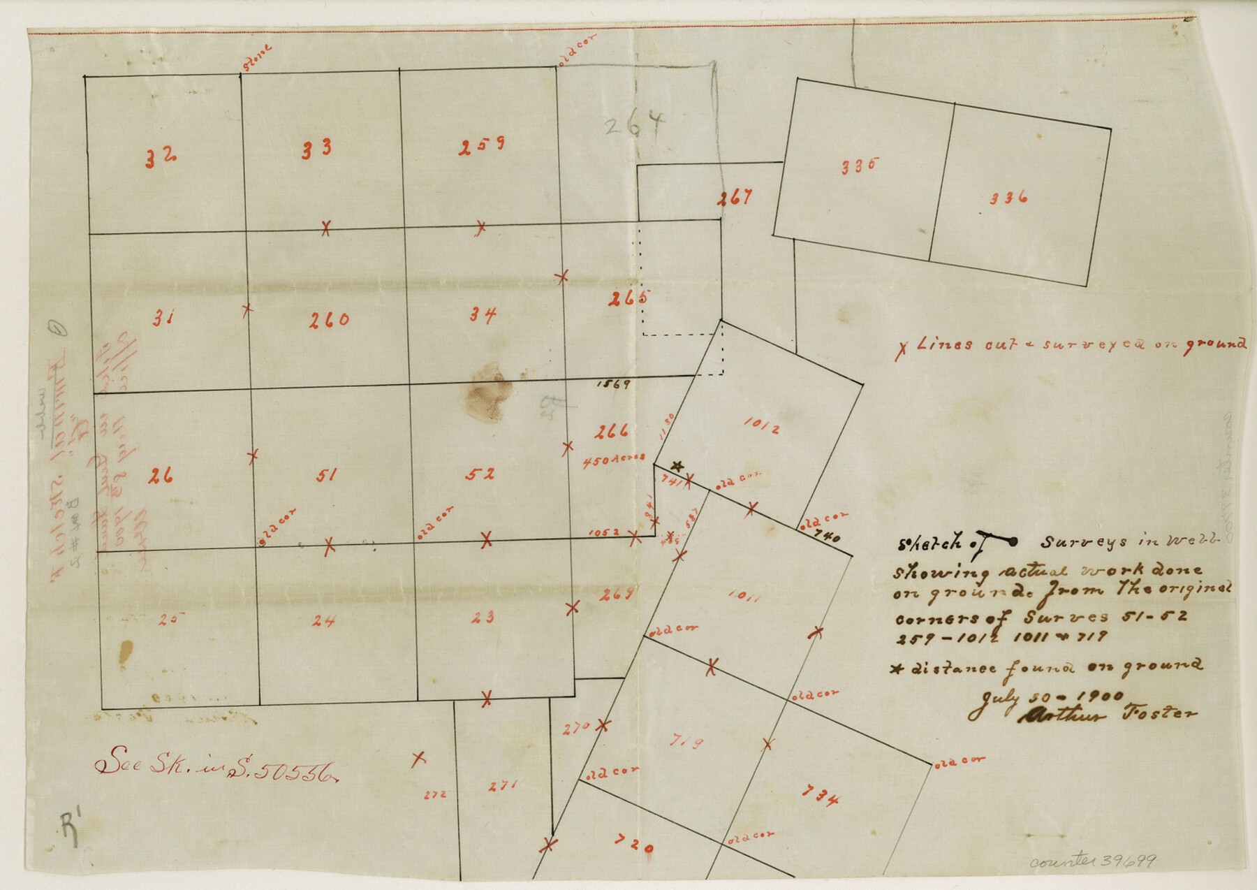
Webb County Sketch File F
Sketch of surveys in Webb showing actual work done on ground from the original corners of surveys 51, 52, 259, 1012, 1011, and 719
-
Map/Doc
39699
-
Collection
General Map Collection
-
Object Dates
7/30/1900 (Creation Date)
8/8/1900 (File Date)
-
People and Organizations
Arthur Foster (Surveyor/Engineer)
-
Counties
Webb
-
Subjects
Surveying Sketch File
-
Height x Width
10.7 x 15.1 inches
27.2 x 38.4 cm
-
Medium
paper, manuscript
Part of: General Map Collection
Webb County Sketch File 9c

Print $20.00
- Digital $50.00
Webb County Sketch File 9c
1930
Size 18.7 x 22.1 inches
Map/Doc 12621
Current Miscellaneous File 103

Print $4.00
- Digital $50.00
Current Miscellaneous File 103
1840
Size 11.2 x 8.8 inches
Map/Doc 74675
[Sketch for Mineral Application 13271- Trinity River]
![65627, [Sketch for Mineral Application 13271- Trinity River], General Map Collection](https://historictexasmaps.com/wmedia_w700/maps/65627.tif.jpg)
Print $40.00
- Digital $50.00
[Sketch for Mineral Application 13271- Trinity River]
1925
Size 63.4 x 25.0 inches
Map/Doc 65627
Fisher County Sketch File 10

Print $20.00
- Digital $50.00
Fisher County Sketch File 10
Size 9.7 x 37.0 inches
Map/Doc 11477
Caldwell County Sketch File 4

Print $8.00
- Digital $50.00
Caldwell County Sketch File 4
Size 8.8 x 6.9 inches
Map/Doc 35831
San Antonio - Downtown - Riverwalk

San Antonio - Downtown - Riverwalk
Size 11.8 x 17.8 inches
Map/Doc 94290
Liberty County Working Sketch 91a

Print $40.00
- Digital $50.00
Liberty County Working Sketch 91a
1919
Size 48.6 x 42.1 inches
Map/Doc 65457
Duval County Rolled Sketch 28

Print $20.00
- Digital $50.00
Duval County Rolled Sketch 28
1947
Size 15.9 x 23.7 inches
Map/Doc 5745
Wichita County

Print $20.00
- Digital $50.00
Wichita County
1971
Size 39.1 x 40.8 inches
Map/Doc 95673
Lampasas County Boundary File 16a

Print $28.00
- Digital $50.00
Lampasas County Boundary File 16a
Size 13.9 x 8.4 inches
Map/Doc 56223
Hemphill County Sketch File 8

Print $9.00
- Digital $50.00
Hemphill County Sketch File 8
Size 14.3 x 8.9 inches
Map/Doc 26308
Crane County Working Sketch 6

Print $40.00
- Digital $50.00
Crane County Working Sketch 6
1928
Size 92.2 x 25.3 inches
Map/Doc 68283
You may also like
Carson County Sketch File 1

Print $20.00
- Digital $50.00
Carson County Sketch File 1
Size 16.8 x 18.5 inches
Map/Doc 11053
Eastland County Sketch File 8

Print $8.00
- Digital $50.00
Eastland County Sketch File 8
1872
Size 12.9 x 8.1 inches
Map/Doc 21576
Copy of Surveyor's Field Book, Morris Browning - In Blocks 7, 5 & 4, I&GNRRCo., Hutchinson and Carson Counties, Texas

Print $2.00
- Digital $50.00
Copy of Surveyor's Field Book, Morris Browning - In Blocks 7, 5 & 4, I&GNRRCo., Hutchinson and Carson Counties, Texas
1888
Size 7.0 x 8.9 inches
Map/Doc 62277
Flight Mission No. DQO-8K, Frame 69, Galveston County

Print $20.00
- Digital $50.00
Flight Mission No. DQO-8K, Frame 69, Galveston County
1952
Size 18.8 x 22.5 inches
Map/Doc 85173
Jackson County Sketch File 4

Print $20.00
- Digital $50.00
Jackson County Sketch File 4
Size 18.2 x 22.7 inches
Map/Doc 11834
Live Oak County Working Sketch 23

Print $40.00
- Digital $50.00
Live Oak County Working Sketch 23
1976
Size 68.2 x 43.5 inches
Map/Doc 70608
Louisiana and Texas Intracoastal Waterway - High Island to Port Bolivar Dredging - Sheet 5

Print $20.00
- Digital $50.00
Louisiana and Texas Intracoastal Waterway - High Island to Port Bolivar Dredging - Sheet 5
1943
Size 31.4 x 41.8 inches
Map/Doc 61824
Wise County Rolled Sketch 4

Print $20.00
- Digital $50.00
Wise County Rolled Sketch 4
1955
Size 20.0 x 13.7 inches
Map/Doc 8278
Flight Mission No. DAG-24K, Frame 127, Matagorda County

Print $20.00
- Digital $50.00
Flight Mission No. DAG-24K, Frame 127, Matagorda County
1953
Size 18.5 x 22.2 inches
Map/Doc 86545

Flight Mission No. CRE-1R, Frame 129, Jackson County

Print $20.00
- Digital $50.00
Flight Mission No. CRE-1R, Frame 129, Jackson County
1956
Size 18.5 x 22.3 inches
Map/Doc 85337
Williamson County Sketch File 29

Print $18.00
- Digital $50.00
Williamson County Sketch File 29
Size 10.2 x 8.2 inches
Map/Doc 40377