Carson County Sketch File 1
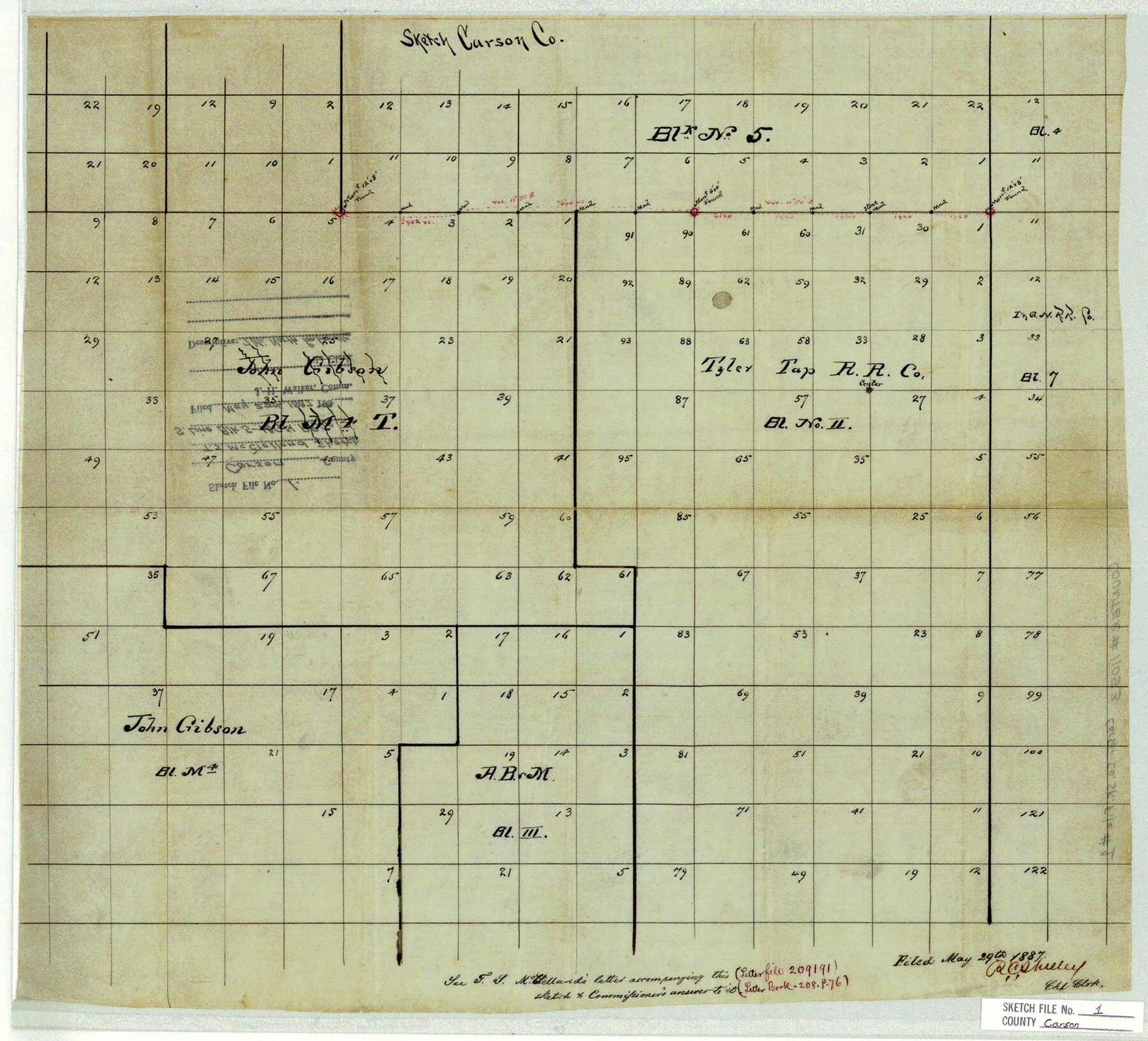
[Sketch of the south line of Block 5, I. & G. N. R.R. Co.]
-
Map/Doc
11053
-
Collection
General Map Collection
-
Object Dates
1887/5/29 (File Date)
-
People and Organizations
T.S. McClelland (Surveyor/Engineer)
-
Counties
Carson
-
Subjects
Surveying Sketch File
-
Height x Width
16.8 x 18.5 inches
42.7 x 47.0 cm
-
Medium
paper, manuscript
Part of: General Map Collection
Flight Mission No. DQO-6K, Frame 33, Galveston County

Print $20.00
- Digital $50.00
Flight Mission No. DQO-6K, Frame 33, Galveston County
1952
Size 18.8 x 22.4 inches
Map/Doc 85099
Comanche County Working Sketch 6

Print $20.00
- Digital $50.00
Comanche County Working Sketch 6
1935
Size 26.4 x 17.8 inches
Map/Doc 68140
Mills County Boundary File 5

Print $8.00
- Digital $50.00
Mills County Boundary File 5
Size 14.2 x 8.7 inches
Map/Doc 57296
Llano County Working Sketch 3

Print $20.00
- Digital $50.00
Llano County Working Sketch 3
1949
Size 23.6 x 24.0 inches
Map/Doc 70621
Hutchinson County Rolled Sketch 9

Print $20.00
- Digital $50.00
Hutchinson County Rolled Sketch 9
Size 25.5 x 27.8 inches
Map/Doc 6280
Pecos County Rolled Sketch 145

Print $20.00
- Digital $50.00
Pecos County Rolled Sketch 145
1957
Size 37.2 x 27.6 inches
Map/Doc 7278
Bandera County Sketch File 24

Print $4.00
- Digital $50.00
Bandera County Sketch File 24
Size 9.3 x 8.3 inches
Map/Doc 14014
Hudspeth County Working Sketch 11

Print $20.00
- Digital $50.00
Hudspeth County Working Sketch 11
1946
Size 32.1 x 36.2 inches
Map/Doc 66292

Trinity River, Balltown Sheet/Pilot Grove Creek

Print $20.00
- Digital $50.00
Trinity River, Balltown Sheet/Pilot Grove Creek
1938
Size 40.1 x 33.7 inches
Map/Doc 65196
Right of Way & Track Map San Antonio & Aransas Pass Railway Co.

Print $40.00
- Digital $50.00
Right of Way & Track Map San Antonio & Aransas Pass Railway Co.
1919
Size 25.3 x 56.5 inches
Map/Doc 64024
Hays County Sketch File 1

Print $2.00
- Digital $50.00
Hays County Sketch File 1
1856
Size 12.6 x 8.3 inches
Map/Doc 26199
You may also like
Webb County Sketch File 4

Print $22.00
- Digital $50.00
Webb County Sketch File 4
1855
Size 8.4 x 14.2 inches
Map/Doc 39716
Andrews County Rolled Sketch 9

Print $20.00
- Digital $50.00
Andrews County Rolled Sketch 9
1930
Size 25.3 x 43.6 inches
Map/Doc 77160
Blanco County Working Sketch 40

Print $20.00
- Digital $50.00
Blanco County Working Sketch 40
1986
Size 28.3 x 24.5 inches
Map/Doc 67400
Presidio County Sketch File 99

Print $8.00
- Digital $50.00
Presidio County Sketch File 99
1955
Size 11.2 x 8.8 inches
Map/Doc 34787
Hudspeth County Rolled Sketch 71

Print $40.00
- Digital $50.00
Hudspeth County Rolled Sketch 71
1992
Size 38.2 x 48.6 inches
Map/Doc 9234
Clay County Sketch File 12

Print $4.00
- Digital $50.00
Clay County Sketch File 12
1873
Size 13.0 x 8.2 inches
Map/Doc 18411
Brewster County Rolled Sketch 72

Print $20.00
- Digital $50.00
Brewster County Rolled Sketch 72
1941
Size 42.0 x 28.4 inches
Map/Doc 5238
English Field Notes of the Spanish Archives - Books DB3 & WR

English Field Notes of the Spanish Archives - Books DB3 & WR
1835
Map/Doc 96548
Brewster County Sketch File FN-31

Print $4.00
- Digital $50.00
Brewster County Sketch File FN-31
1975
Size 11.3 x 8.8 inches
Map/Doc 15852
Crockett County Rolled Sketch 50

Print $20.00
- Digital $50.00
Crockett County Rolled Sketch 50
1940
Size 31.5 x 40.7 inches
Map/Doc 8714
Liberty County Rolled Sketch 15

Print $20.00
- Digital $50.00
Liberty County Rolled Sketch 15
2015
Size 36.1 x 24.3 inches
Map/Doc 94025
Cameron County Sketch File 8

Print $73.00
- Digital $50.00
Cameron County Sketch File 8
1982
Size 11.4 x 8.9 inches
Map/Doc 17124