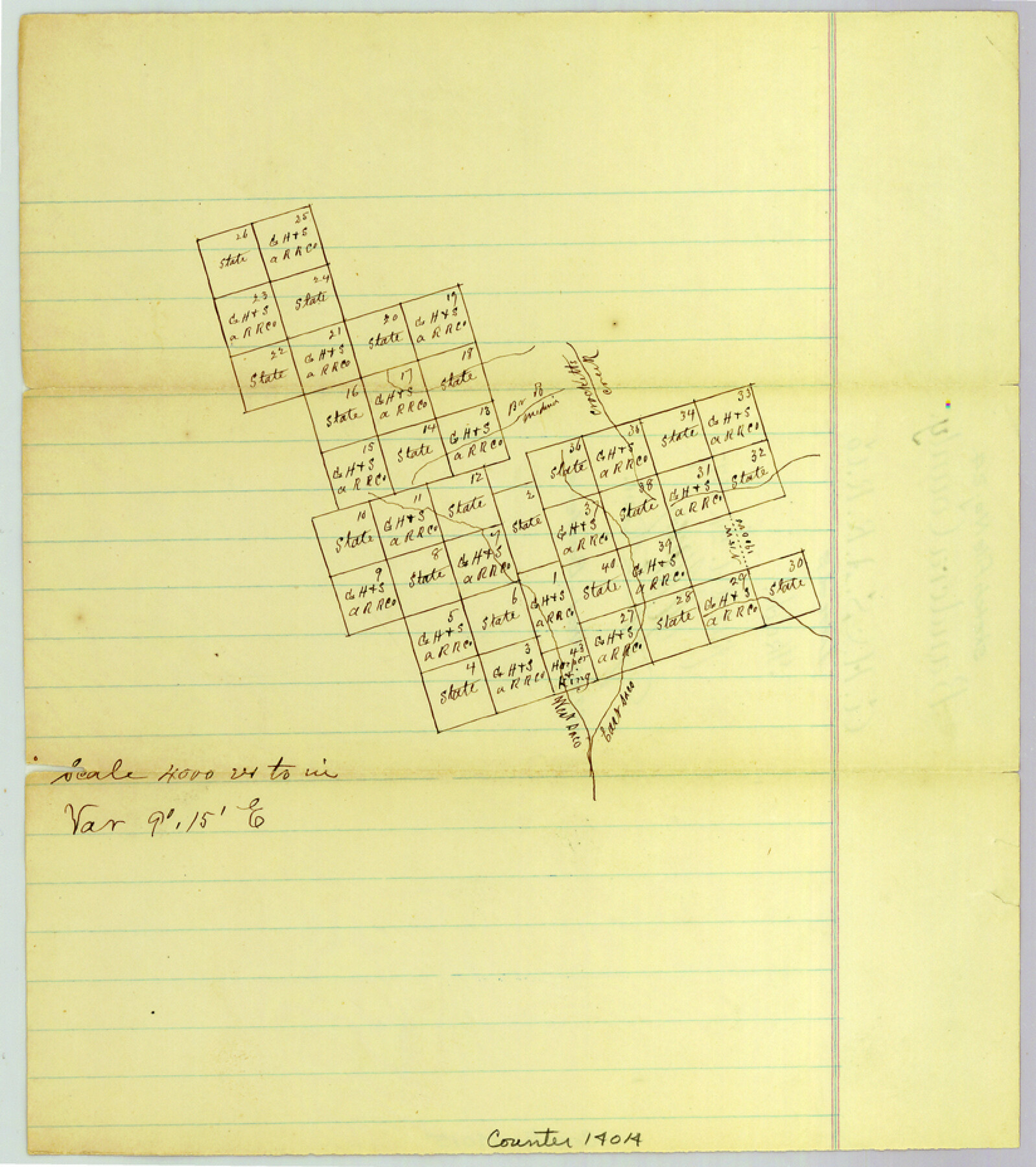
Bandera County Sketch File 24
[Sketch of G. H. & S. A. R.R. Co. lands west of Bandera]
- 
                          Map/Doc14014
- 
                            CollectionGeneral Map Collection
- 
                            Object Dates1877/10/24 (File Date)
- 
                            CountiesBandera
- 
                            SubjectsSurveying Sketch File
- 
                            Height x Width9.3 x 8.3 inches23.6 x 21.1 cm
- 
                            Mediumpaper, manuscript
- 
                            Scale1" = 4000 varas
- 
                            FeaturesCrockett's CreekWest Saco [Creek]East Saco [Creek]
Part of: General Map Collection
            Uvalde County Working Sketch 63


                                            Print $20.00                    
                                             -                         Digital $50.00                                    
                Uvalde County Working Sketch 63
1995
Size 26.8 x 42.0 inches
                                Map/Doc 72133
            
            Live Oak County Sketch File 13


                                            Print $17.00                    
                                             -                         Digital $50.00                                    
                Live Oak County Sketch File 13
1880
Size 10.2 x 13.7 inches
                                Map/Doc 30270
            
            Palo Pinto County Working Sketch 16


                                            Print $20.00                    
                                             -                         Digital $50.00                                    
                Palo Pinto County Working Sketch 16
1974
Size 35.5 x 42.4 inches
                                Map/Doc 71399
            
            Wheeler County Boundary File 1c


                                            Print $4.00                    
                                             -                         Digital $50.00                                    
                Wheeler County Boundary File 1c
Size 11.4 x 8.9 inches
                                Map/Doc 59870
            
            Brazoria County NRC Article 33.136 Sketch 15


                                            Print $44.00                    
                                             -                         Digital $50.00                                    
                Brazoria County NRC Article 33.136 Sketch 15
2014
Size 39.8 x 30.0 inches
                                Map/Doc 94698
            
            Plat of Jasper, Sabine, San Augustine, Shelby, Harrison and South Part of Nacogdoches Counties


                                            Print $2.00                    
                                             -                         Digital $50.00                                    
                Plat of Jasper, Sabine, San Augustine, Shelby, Harrison and South Part of Nacogdoches Counties
1841
Size 13.7 x 9.2 inches
                                Map/Doc 3174
            
            Map of the Fort Worth and Denver City Railway, through Wilbarger County Texas, 1882


                                            Print $40.00                    
                                             -                         Digital $50.00                                    
                Map of the Fort Worth and Denver City Railway, through Wilbarger County Texas, 1882
Size 22.6 x 79.4 inches
                                Map/Doc 64427
            
            Map of subdivision of submerged land in the Gulf of Mexico fronting on Matagorda Island and Peninsula


                                            Print $40.00                    
                                             -                         Digital $50.00                                    
                Map of subdivision of submerged land in the Gulf of Mexico fronting on Matagorda Island and Peninsula
1940
Size 28.3 x 60.5 inches
                                Map/Doc 2928
            
            Potter County Rolled Sketch 8


                                            Print $20.00                    
                                             -                         Digital $50.00                                    
                Potter County Rolled Sketch 8
1920
Size 26.3 x 30.7 inches
                                Map/Doc 7321
            
            Travis County Rolled Sketch 37


                                            Print $20.00                    
                                             -                         Digital $50.00                                    
                Travis County Rolled Sketch 37
1942
Size 33.6 x 32.7 inches
                                Map/Doc 10737
            
            Cochran County Rolled Sketch 5


                                            Print $20.00                    
                                             -                         Digital $50.00                                    
                Cochran County Rolled Sketch 5
1949
Size 21.5 x 22.0 inches
                                Map/Doc 5502
            You may also like
            Denton County Sketch File 5


                                            Print $6.00                    
                                             -                         Digital $50.00                                    
                Denton County Sketch File 5
1855
Size 9.8 x 8.1 inches
                                Map/Doc 20693
            
            [Surveys along the Sabine River made under G.W. Smyth, Commissioner]
            
                                    ![90, [Surveys along the Sabine River made under G.W. Smyth, Commissioner], General Map Collection](https://historictexasmaps.com/wmedia_w700/maps/90.tif.jpg) 


    ![90, [Surveys along the Sabine River made under G.W. Smyth, Commissioner], General Map Collection](https://historictexasmaps.com/wmedia_w700/maps/90.tif.jpg) 
                                
            
                                            Print $20.00                    
                                             -                         Digital $50.00                                    
                [Surveys along the Sabine River made under G.W. Smyth, Commissioner]
1837
Size 13.9 x 17.0 inches
                                Map/Doc 90
            
            Rusk County Rolled Sketch 11


                                            Print $20.00                    
                                             -                         Digital $50.00                                    
                Rusk County Rolled Sketch 11
1956
Size 33.2 x 43.3 inches
                                Map/Doc 9877
            
            Young County Working Sketch 22


                                            Print $20.00                    
                                             -                         Digital $50.00                                    
                Young County Working Sketch 22
1965
Size 26.5 x 32.3 inches
                                Map/Doc 62045
            
            General Highway Map, Martin County, Texas


                                            Print $20.00                    
                                    
                General Highway Map, Martin County, Texas
1961
Size 18.1 x 24.6 inches
                                Map/Doc 79583
            
            Crockett County Rolled Sketch 21


                                            Print $20.00                    
                                             -                         Digital $50.00                                    
                Crockett County Rolled Sketch 21
Size 33.0 x 24.4 inches
                                Map/Doc 5582
            
            The Republic County of Fort Bend. December 29, 1845


                                            Print $20.00                    
                                    
                The Republic County of Fort Bend. December 29, 1845
2020
Size 14.7 x 21.6 inches
                                Map/Doc 96142
            
            Young County Sketch File 10


                                            Print $20.00                    
                                             -                         Digital $50.00                                    
                Young County Sketch File 10
Size 14.1 x 17.7 inches
                                Map/Doc 12711
            
            Guadalupe County


                                            Print $20.00                    
                                             -                         Digital $50.00                                    
                Guadalupe County
1880
Size 24.9 x 22.6 inches
                                Map/Doc 4553
            
            Rusk County Working Sketch 21


                                            Print $20.00                    
                                             -                         Digital $50.00                                    
                Rusk County Working Sketch 21
1953
Size 27.6 x 28.3 inches
                                Map/Doc 63657
            
            Flight Mission No. BRA-6M, Frame 150, Jefferson County


                                            Print $20.00                    
                                             -                         Digital $50.00                                    
                Flight Mission No. BRA-6M, Frame 150, Jefferson County
1953
Size 18.5 x 22.4 inches
                                Map/Doc 85451
             
                             
                                