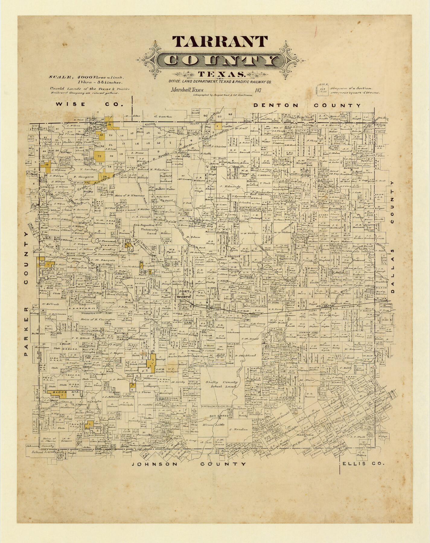
Tarrant County, Texas
- 
                          Map/Doc758
- 
                            CollectionMaddox Collection
- 
                            Object Dates[1870-1879] (Creation Date)
- 
                            People and OrganizationsTexas and Pacific Railway Company (Publisher)August Gast & Co. (Lithographer)
- 
                            CountiesTarrant
- 
                            SubjectsCounty
- 
                            Height x Width24.1 x 19.1 inches61.2 x 48.5 cm
- 
                            Mediumpaper, etching/engraving/lithograph
- 
                            Scale1:4000
- 
                            CommentsAdopted in 2006 by Martha A. Compton, Dallas, Texas and conservation funded in 2007.
- 
                            FeaturesArlingtonWalnut CreekMansfieldOak GroveClear Fork [Creek]Shoal CreekTurkey CreekVillage CreekFish CreekJohnson Sta[tion]Weatherford RoadVillage Creek [Railroad Stop]T&PHenriett CreekTrading House CreekBear CreekDenton RoadWalker's CreekPrairie CreekLittle Fossil CreekBirdsvilleFort WorthWest ForkDecatur RoadDenton ForkElizabeth Creek
Part of: Maddox Collection
            Working Sketch of surveys in Mason, Kimble & Menard Counties


                                            Print $20.00                    
                                             -                         Digital $50.00                                    
                Working Sketch of surveys in Mason, Kimble & Menard Counties
1900
Size 32.1 x 42.4 inches
                                Map/Doc 75805
            
            Map of Rockport Texas, Aransas County


                                            Print $20.00                    
                                             -                         Digital $50.00                                    
                Map of Rockport Texas, Aransas County
1888
Size 29.0 x 20.5 inches
                                Map/Doc 380
            
            Plat of Surveys in Hidalgo Co.


                                            Print $20.00                    
                                             -                         Digital $50.00                                    
                Plat of Surveys in Hidalgo Co.
Size 18.3 x 9.2 inches
                                Map/Doc 75548
            
            [Sketch in Edwards & Sutton Counties, Texas]
            
                                    ![4371, [Sketch in Edwards & Sutton Counties, Texas], Maddox Collection](https://historictexasmaps.com/wmedia_w700/maps/4371.tif.jpg) 


    ![4371, [Sketch in Edwards & Sutton Counties, Texas], Maddox Collection](https://historictexasmaps.com/wmedia_w700/maps/4371.tif.jpg) 
                                
            
                                            Print $20.00                    
                                             -                         Digital $50.00                                    
                [Sketch in Edwards & Sutton Counties, Texas]
Size 16.7 x 30.2 inches
                                Map/Doc 4371
            
            Austin, Texas Congress Ave. Drainage


                                            Print $20.00                    
                                             -                         Digital $50.00                                    
                Austin, Texas Congress Ave. Drainage
1903
Size 15.1 x 15.5 inches
                                Map/Doc 75797
            
            Gillespie County, Texas


                                            Print $20.00                    
                                             -                         Digital $50.00                                    
                Gillespie County, Texas
1879
Size 21.2 x 26.9 inches
                                Map/Doc 547
            
            Map of Cherokee County, Texas


                                            Print $20.00                    
                                             -                         Digital $50.00                                    
                Map of Cherokee County, Texas
1879
Size 30.8 x 24.0 inches
                                Map/Doc 696
            
            Map of the north west portion of Hutchinson County showing the proposed resurvey of Block M24


                                            Print $20.00                    
                                             -                         Digital $50.00                                    
                Map of the north west portion of Hutchinson County showing the proposed resurvey of Block M24
Size 29.1 x 31.9 inches
                                Map/Doc 75814
            
            [Sketch showing surveys in Sutton and Val Verde Counties, Texas]
            
                                    ![10779, [Sketch showing surveys in Sutton and Val Verde Counties, Texas], Maddox Collection](https://historictexasmaps.com/wmedia_w700/maps/10779.tif.jpg) 


    ![10779, [Sketch showing surveys in Sutton and Val Verde Counties, Texas], Maddox Collection](https://historictexasmaps.com/wmedia_w700/maps/10779.tif.jpg) 
                                
            
                                            Print $20.00                    
                                             -                         Digital $50.00                                    
                [Sketch showing surveys in Sutton and Val Verde Counties, Texas]
1880
Size 28.0 x 14.5 inches
                                Map/Doc 10779
            
            [Surveying Sketch of Kendall County School Land, et al in Kerr County, Texas]
            
                                    ![5072, [Surveying Sketch of Kendall County School Land, et al in Kerr County, Texas], Maddox Collection](https://historictexasmaps.com/wmedia_w700/maps/5072-1.tif.jpg) 


    ![5072, [Surveying Sketch of Kendall County School Land, et al in Kerr County, Texas], Maddox Collection](https://historictexasmaps.com/wmedia_w700/maps/5072-1.tif.jpg) 
                                
            
                                            Print $3.00                    
                                             -                         Digital $50.00                                    
                [Surveying Sketch of Kendall County School Land, et al in Kerr County, Texas]
Size 11.9 x 12.9 inches
                                Map/Doc 5072
            
            [East half of Travis County]
            
                                    ![75802, [East half of Travis County], Maddox Collection](https://historictexasmaps.com/wmedia_w700/maps/75802.tif.jpg) 


    ![75802, [East half of Travis County], Maddox Collection](https://historictexasmaps.com/wmedia_w700/maps/75802.tif.jpg) 
                                
            
                                            Print $20.00                    
                                             -                         Digital $50.00                                    
                [East half of Travis County]
Size 42.5 x 29.8 inches
                                Map/Doc 75802
            
            Camp County, Texas


                                            Print $3.00                    
                                             -                         Digital $50.00                                    
                Camp County, Texas
1879
Size 9.6 x 16.8 inches
                                Map/Doc 512
            You may also like
            Crosby County Sketch File 5


                                            Print $10.00                    
                                             -                         Digital $50.00                                    
                Crosby County Sketch File 5
1887
Size 9.2 x 7.8 inches
                                Map/Doc 20002
            
            Stonewall County Working Sketch 18


                                            Print $20.00                    
                                             -                         Digital $50.00                                    
                Stonewall County Working Sketch 18
1956
Size 24.0 x 21.6 inches
                                Map/Doc 62325
            
            Matagorda County NRC Article 33.136 Sketch 3


                                            Print $20.00                    
                                             -                         Digital $50.00                                    
                Matagorda County NRC Article 33.136 Sketch 3
2008
Size 36.0 x 24.0 inches
                                Map/Doc 88834
            
            San Jacinto River and Tributaries, Texas - Survey of 1939


                                            Print $20.00                    
                                             -                         Digital $50.00                                    
                San Jacinto River and Tributaries, Texas - Survey of 1939
1939
Size 27.7 x 40.5 inches
                                Map/Doc 60310
            
            Jeff Davis County Sketch File 31


                                            Print $34.00                    
                                             -                         Digital $50.00                                    
                Jeff Davis County Sketch File 31
Size 10.6 x 8.4 inches
                                Map/Doc 28023
            
            Reeves County Sketch File 21


                                            Print $20.00                    
                                             -                         Digital $50.00                                    
                Reeves County Sketch File 21
Size 21.9 x 21.7 inches
                                Map/Doc 12246
            
            Bowie County Working Sketch 17


                                            Print $20.00                    
                                             -                         Digital $50.00                                    
                Bowie County Working Sketch 17
1962
Size 24.5 x 20.0 inches
                                Map/Doc 67421
            
            Brazos River, Brazos River Sheet 3


                                            Print $20.00                    
                                             -                         Digital $50.00                                    
                Brazos River, Brazos River Sheet 3
1926
Size 21.3 x 36.0 inches
                                Map/Doc 78266
            
            Midland County Working Sketch 18


                                            Print $40.00                    
                                             -                         Digital $50.00                                    
                Midland County Working Sketch 18
1956
Size 26.5 x 49.5 inches
                                Map/Doc 70998
            
            [Surveys in Mills, Hamilton, Coryell and Bell Counties]
            
                                    ![78362, [Surveys in Mills, Hamilton, Coryell and Bell Counties], General Map Collection](https://historictexasmaps.com/wmedia_w700/maps/78362.tif.jpg) 


    ![78362, [Surveys in Mills, Hamilton, Coryell and Bell Counties], General Map Collection](https://historictexasmaps.com/wmedia_w700/maps/78362.tif.jpg) 
                                
            
                                            Print $20.00                    
                                             -                         Digital $50.00                                    
                [Surveys in Mills, Hamilton, Coryell and Bell Counties]
Size 33.9 x 19.5 inches
                                Map/Doc 78362
            
            Polk County Working Sketch 16


                                            Print $20.00                    
                                             -                         Digital $50.00                                    
                Polk County Working Sketch 16
1947
Size 45.7 x 27.3 inches
                                Map/Doc 71631
            
            Hutchinson County Working Sketch 4


                                            Print $20.00                    
                                             -                         Digital $50.00                                    
                Hutchinson County Working Sketch 4
1907
Size 25.0 x 23.4 inches
                                Map/Doc 66362
            