
Kent County, Texas
-
Map/Doc
736
-
Collection
Maddox Collection
-
Object Dates
[1880 ca.] (Creation Date)
-
Counties
Kent
-
Subjects
County
-
Height x Width
23.2 x 19.8 inches
58.9 x 50.3 cm
-
Medium
linen, manuscript
-
Comments
Conservation funded in 2012 by Friends of the Texas General Land Office.
-
Features
Duck Creek
North Prong [of Croton River]
Middle Prong [of Croton River]
Brazos River
Salt Fork [of Brazos River]
Alamo or Yellow Horse River
Alamo River
Yellow Horse River
McElgin [Mountain]
Maylocah Mountain
Polk Peak
Double Mountain Fork [of Alamo or Yellow River]
Part of: Maddox Collection
Jasper County

Print $20.00
- Digital $50.00
Jasper County
1882
Size 17.6 x 14.0 inches
Map/Doc 75779
[Surveying Sketch of Buckman, et al in Unknown County]
![498, [Surveying Sketch of Buckman, et al in Unknown County], Maddox Collection](https://historictexasmaps.com/wmedia_w700/maps/498.tif.jpg)
Print $3.00
- Digital $50.00
[Surveying Sketch of Buckman, et al in Unknown County]
Size 11.7 x 11.9 inches
Map/Doc 498
Hopkins County

Print $20.00
- Digital $50.00
Hopkins County
1888
Size 36.4 x 36.6 inches
Map/Doc 448
Kent County, Texas

Print $20.00
- Digital $50.00
Kent County, Texas
1880
Size 23.2 x 19.8 inches
Map/Doc 736
Mitchell County, Texas

Print $20.00
- Digital $50.00
Mitchell County, Texas
1870
Size 22.7 x 18.0 inches
Map/Doc 741
Map of surveys 191 & 192 T. C. R.R. Co. in Travis County, Texas

Print $20.00
- Digital $50.00
Map of surveys 191 & 192 T. C. R.R. Co. in Travis County, Texas
1915
Size 20.6 x 13.6 inches
Map/Doc 75554
Map of Mason County, Texas

Print $20.00
- Digital $50.00
Map of Mason County, Texas
Size 26.0 x 19.2 inches
Map/Doc 404
Cottle County, Texas

Print $20.00
- Digital $50.00
Cottle County, Texas
1891
Size 23.1 x 17.0 inches
Map/Doc 619
Camp County, Texas

Print $3.00
- Digital $50.00
Camp County, Texas
1879
Size 9.6 x 16.8 inches
Map/Doc 512
[Juan Jose Balli Survey, Kenedy County, Texas]
![[Juan Jose Balli Survey, Kenedy County, Texas]](https://historictexasmaps.com/wmedia_w700/maps/4444 - new.tif.jpg)
Print $3.00
- Digital $50.00
[Juan Jose Balli Survey, Kenedy County, Texas]
Size 9.8 x 13.4 inches
Map/Doc 4444
Plat Town of Swearingen, Cottle Co., Texas

Print $20.00
- Digital $50.00
Plat Town of Swearingen, Cottle Co., Texas
1918
Size 39.8 x 30.6 inches
Map/Doc 513
Map of Briscoe County, Texas

Print $20.00
- Digital $50.00
Map of Briscoe County, Texas
1879
Size 22.6 x 18.0 inches
Map/Doc 614
You may also like
Runnels County Sketch File 12

Print $20.00
Runnels County Sketch File 12
1883
Size 32.9 x 30.9 inches
Map/Doc 10592
Harris County Texas

Print $20.00
- Digital $50.00
Harris County Texas
1908
Size 19.7 x 24.7 inches
Map/Doc 11652
Milam County Boundary File 6c

Print $2.00
- Digital $50.00
Milam County Boundary File 6c
Size 11.2 x 8.5 inches
Map/Doc 57250
Wise County Sketch File 34

Print $6.00
- Digital $50.00
Wise County Sketch File 34
1856
Size 6.3 x 9.6 inches
Map/Doc 40592
Flight Mission No. DCL-5C, Frame 65, Kenedy County

Print $20.00
- Digital $50.00
Flight Mission No. DCL-5C, Frame 65, Kenedy County
1943
Size 17.9 x 22.4 inches
Map/Doc 85848
Terrell County Sketch File 20

Print $6.00
- Digital $50.00
Terrell County Sketch File 20
1910
Size 10.9 x 12.6 inches
Map/Doc 37946

Right of Way & Track Map Houston & Brazos Valley Ry. operated by Houston & Brazos Valley Ry. Co., Hoskins Mound Branch

Print $40.00
- Digital $50.00
Right of Way & Track Map Houston & Brazos Valley Ry. operated by Houston & Brazos Valley Ry. Co., Hoskins Mound Branch
1924
Size 25.0 x 56.7 inches
Map/Doc 66713
Culberson County Working Sketch 46
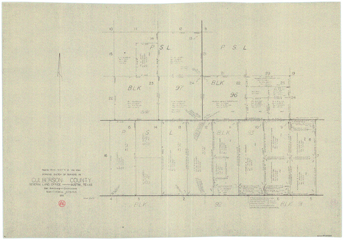
Print $20.00
- Digital $50.00
Culberson County Working Sketch 46
1971
Size 25.9 x 37.4 inches
Map/Doc 68500
[H. & G. N. Block 1]
![90940, [H. & G. N. Block 1], Twichell Survey Records](https://historictexasmaps.com/wmedia_w700/maps/90940-1.tif.jpg)
Print $20.00
- Digital $50.00
[H. & G. N. Block 1]
1873
Size 17.3 x 14.2 inches
Map/Doc 90940
[Right of Way & Track Map, The Texas & Pacific Ry. Co. Main Line]
![64669, [Right of Way & Track Map, The Texas & Pacific Ry. Co. Main Line], General Map Collection](https://historictexasmaps.com/wmedia_w700/maps/64669.tif.jpg)
Print $20.00
- Digital $50.00
[Right of Way & Track Map, The Texas & Pacific Ry. Co. Main Line]
Size 11.0 x 18.5 inches
Map/Doc 64669
[Surveys in the Bexar District along the Medina River west of the San Antonio River]
![57, [Surveys in the Bexar District along the Medina River west of the San Antonio River], General Map Collection](https://historictexasmaps.com/wmedia_w700/maps/57.tif.jpg)
Print $2.00
- Digital $50.00
[Surveys in the Bexar District along the Medina River west of the San Antonio River]
1842
Size 8.0 x 15.2 inches
Map/Doc 57