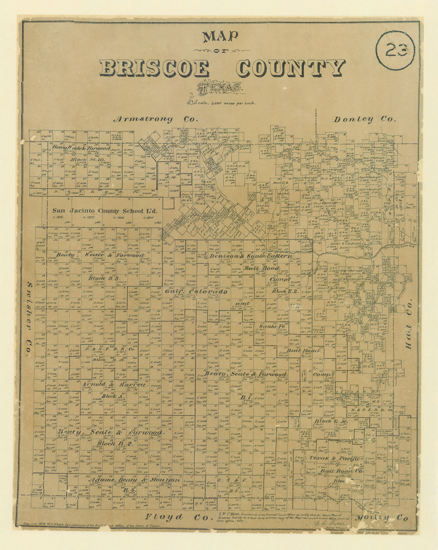
Map of Briscoe County, Texas
-
Map/Doc
614
-
Collection
Maddox Collection
-
Object Dates
1879 (Creation Date)
-
People and Organizations
General Land Office (Publisher)
August Gast & Co. (Lithographer)
-
Counties
Briscoe
-
Subjects
County
-
Height x Width
22.6 x 18.0 inches
57.4 x 45.7 cm
-
Medium
paper, etching/engraving/lithograph
-
Scale
1:4000
-
Comments
Conservation funded in 2008 by Friends of the Texas General Land Office.
-
Features
Turkey Creek
Campbell Creek
Pilgrim Branch [of Prairie Dog Town Fork]
Battle Creek
Byrne's Fork [of Prairie Dog Town Fork]
Hackberry Creek
Troublesome Creek
Tulo Creek
Prairie Dog Town Fork
Cherokee Creek
Bartoll Creek
Mexican Creek
Antalope Creek
Little Red Creek
Pease River
Part of: Maddox Collection
Lands of Gunter & Munson and Maddox Bros. & Anderson, Tom Green Co. Tex.

Print $20.00
- Digital $50.00
Lands of Gunter & Munson and Maddox Bros. & Anderson, Tom Green Co. Tex.
Size 20.4 x 30.7 inches
Map/Doc 75787
Sketch compiled from records of Collin County in General Land Office

Print $3.00
- Digital $50.00
Sketch compiled from records of Collin County in General Land Office
1878
Size 11.5 x 13.5 inches
Map/Doc 504
Littlefield and White's London Property

Print $20.00
- Digital $50.00
Littlefield and White's London Property
1916
Size 18.5 x 13.0 inches
Map/Doc 75796
Sketch showing connections made in survey of the Jerry Barton preemption

Print $20.00
- Digital $50.00
Sketch showing connections made in survey of the Jerry Barton preemption
1892
Size 18.7 x 23.6 inches
Map/Doc 75557
[Surveying Sketch of Francisco Guerra, Antonio Ramirez, Diego Ynojosa, et al on Rio Grande, Starr County]
![5073, [Surveying Sketch of Francisco Guerra, Antonio Ramirez, Diego Ynojosa, et al on Rio Grande, Starr County], Maddox Collection](https://historictexasmaps.com/wmedia_w700/maps/5073-1.tif.jpg)
Print $20.00
- Digital $50.00
[Surveying Sketch of Francisco Guerra, Antonio Ramirez, Diego Ynojosa, et al on Rio Grande, Starr County]
1914
Size 21.7 x 13.0 inches
Map/Doc 5073
Coryell County, Texas

Print $20.00
- Digital $50.00
Coryell County, Texas
1879
Size 23.5 x 29.1 inches
Map/Doc 704
Gonzales County, Texas

Print $20.00
- Digital $50.00
Gonzales County, Texas
1880
Size 27.3 x 24.7 inches
Map/Doc 447
Map of Galveston County, Texas

Print $20.00
- Digital $50.00
Map of Galveston County, Texas
1879
Size 18.3 x 26.6 inches
Map/Doc 546
Angelina County, Texas

Print $20.00
- Digital $50.00
Angelina County, Texas
1879
Size 21.8 x 28.0 inches
Map/Doc 687
Map of South Brady Ranch, Concho County, Texas

Print $3.00
- Digital $50.00
Map of South Brady Ranch, Concho County, Texas
1880
Size 12.9 x 10.5 inches
Map/Doc 424
McCulloch County, Texas

Print $20.00
- Digital $50.00
McCulloch County, Texas
1879
Size 24.6 x 18.0 inches
Map/Doc 573
[Sketch of surveys in Val Verde County]
![5048, [Sketch of surveys in Val Verde County], Maddox Collection](https://historictexasmaps.com/wmedia_w700/maps/5048.tif.jpg)
Print $20.00
- Digital $50.00
[Sketch of surveys in Val Verde County]
Size 17.3 x 17.1 inches
Map/Doc 5048
You may also like
Nueces County Rolled Sketch 114

Print $20.00
- Digital $50.00
Nueces County Rolled Sketch 114
1992
Size 18.1 x 24.6 inches
Map/Doc 7125
Map of Clay County, Texas

Print $20.00
- Digital $50.00
Map of Clay County, Texas
1880
Size 33.0 x 23.2 inches
Map/Doc 699
Dawson County

Print $20.00
- Digital $50.00
Dawson County
1892
Size 27.1 x 23.3 inches
Map/Doc 66797
Hardeman County Sketch File 5

Print $6.00
- Digital $50.00
Hardeman County Sketch File 5
Size 12.9 x 4.4 inches
Map/Doc 24994
Flight Mission No. DQN-1K, Frame 134, Calhoun County

Print $20.00
- Digital $50.00
Flight Mission No. DQN-1K, Frame 134, Calhoun County
1953
Size 18.5 x 22.2 inches
Map/Doc 84197
Sutton County Rolled Sketch 42

Print $20.00
- Digital $50.00
Sutton County Rolled Sketch 42
Size 16.2 x 20.1 inches
Map/Doc 7884
Kimble County Working Sketch 30

Print $20.00
- Digital $50.00
Kimble County Working Sketch 30
1942
Size 24.5 x 21.6 inches
Map/Doc 70098
Lynn County Boundary File 2

Print $6.00
- Digital $50.00
Lynn County Boundary File 2
Size 11.1 x 8.7 inches
Map/Doc 56620
Brewster County Rolled Sketch 114

Print $20.00
- Digital $50.00
Brewster County Rolled Sketch 114
1964
Size 23.8 x 18.9 inches
Map/Doc 5268
Flight Mission No. DQO-2K, Frame 83, Galveston County

Print $20.00
- Digital $50.00
Flight Mission No. DQO-2K, Frame 83, Galveston County
1952
Size 18.8 x 22.5 inches
Map/Doc 85010

Brazoria County NRC Article 33.136 Sketch 11

Print $24.00
- Digital $50.00
Brazoria County NRC Article 33.136 Sketch 11
2012
Size 24.0 x 18.0 inches
Map/Doc 94777