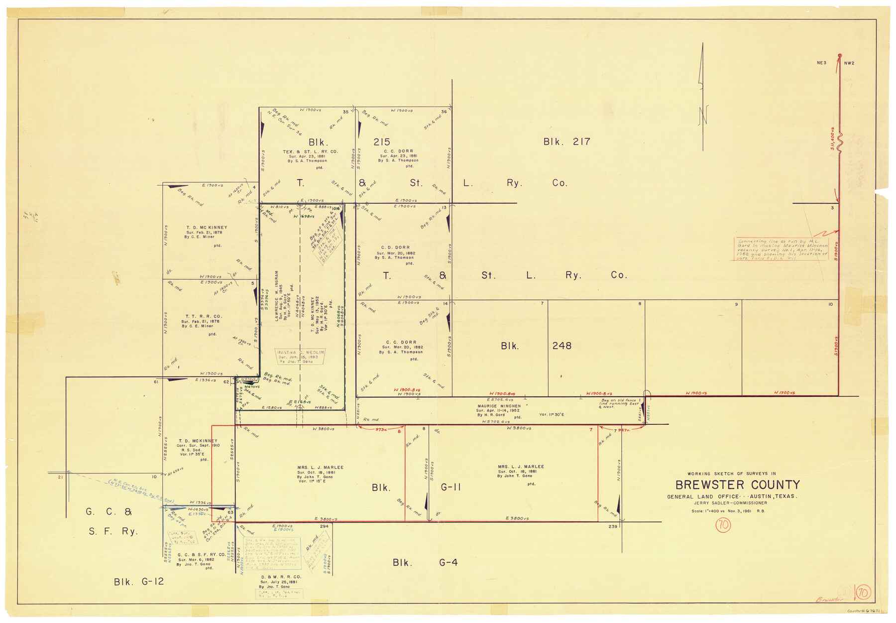
Brewster County Working Sketch 70
-
Map/Doc
67671
-
Collection
General Map Collection
-
Object Dates
11/3/1961 (Creation Date)
-
People and Organizations
Roy Buckholts (Draftsman)
-
Counties
Brewster
-
Subjects
Surveying Working Sketch
-
Height x Width
30.5 x 44.0 inches
77.5 x 111.8 cm
-
Scale
1" = 400 varas
Part of: General Map Collection
Pecos County Rolled Sketch 125

Print $20.00
- Digital $50.00
Pecos County Rolled Sketch 125
1948
Size 32.0 x 41.6 inches
Map/Doc 7266
Gulf Intracoastal Waterway - Aransas Bay to Corpus Christi Bay, Modified Route of Main Channel Location of Spoil Disposal Areas

Print $20.00
- Digital $50.00
Gulf Intracoastal Waterway - Aransas Bay to Corpus Christi Bay, Modified Route of Main Channel Location of Spoil Disposal Areas
1961
Size 31.4 x 42.1 inches
Map/Doc 61829
Hemphill County Sketch File 9

Print $26.00
- Digital $50.00
Hemphill County Sketch File 9
1955
Size 11.0 x 8.8 inches
Map/Doc 26312
Tyler County Working Sketch 18

Print $20.00
- Digital $50.00
Tyler County Working Sketch 18
1965
Size 31.4 x 27.3 inches
Map/Doc 69488
Kaufman County Sketch File 19

Print $30.00
- Digital $50.00
Kaufman County Sketch File 19
1922
Size 11.2 x 8.7 inches
Map/Doc 28666
Austin County Sketch File 11

Print $8.00
- Digital $50.00
Austin County Sketch File 11
1895
Size 11.1 x 8.6 inches
Map/Doc 13877
Kimble County Working Sketch 63

Print $20.00
- Digital $50.00
Kimble County Working Sketch 63
1964
Size 31.2 x 34.2 inches
Map/Doc 70131
Bell County Sketch File 4

Print $40.00
- Digital $50.00
Bell County Sketch File 4
1848
Size 15.9 x 12.6 inches
Map/Doc 14369
North America

Print $20.00
- Digital $50.00
North America
1843
Size 16.7 x 13.7 inches
Map/Doc 95366
Brazoria County Rolled Sketch 48
Print $20.00
- Digital $50.00
Brazoria County Rolled Sketch 48
1952
Size 28.6 x 41.3 inches
Map/Doc 5181
Jones County Working Sketch 4

Print $20.00
- Digital $50.00
Jones County Working Sketch 4
1946
Size 35.5 x 20.6 inches
Map/Doc 66642
Flight Mission No. DAG-28K, Frame 22, Matagorda County

Print $20.00
- Digital $50.00
Flight Mission No. DAG-28K, Frame 22, Matagorda County
1953
Size 18.4 x 22.3 inches
Map/Doc 86590
You may also like
City of Littlefield Lamb County Texas Located on Texas State Capitol League 664

Print $20.00
- Digital $50.00
City of Littlefield Lamb County Texas Located on Texas State Capitol League 664
Size 41.0 x 37.1 inches
Map/Doc 89911
Johnson County Rolled Sketch 1

Print $20.00
- Digital $50.00
Johnson County Rolled Sketch 1
1941
Size 19.4 x 33.4 inches
Map/Doc 6446
Aransas County Working Sketch 3

Print $20.00
- Digital $50.00
Aransas County Working Sketch 3
1928
Size 20.6 x 32.9 inches
Map/Doc 67170
Cooke County Sketch File 42

Print $8.00
- Digital $50.00
Cooke County Sketch File 42
1940
Size 14.3 x 8.8 inches
Map/Doc 19316
Navigation Maps of Gulf Intracoastal Waterway, Port Arthur to Brownsville, Texas

Print $4.00
- Digital $50.00
Navigation Maps of Gulf Intracoastal Waterway, Port Arthur to Brownsville, Texas
1951
Size 16.8 x 21.6 inches
Map/Doc 65419
McMullen County Sketch File 2

Print $22.00
- Digital $50.00
McMullen County Sketch File 2
1849
Size 8.3 x 12.4 inches
Map/Doc 31337
Trinity River, Barnett Crossing Sheet/Brushy and Kings Creek

Print $20.00
- Digital $50.00
Trinity River, Barnett Crossing Sheet/Brushy and Kings Creek
1927
Size 41.3 x 30.2 inches
Map/Doc 65221
[Northwest Garza County around John Walker and Thomas Hughes surveys]
![90906, [Northwest Garza County around John Walker and Thomas Hughes surveys], Twichell Survey Records](https://historictexasmaps.com/wmedia_w700/maps/90906-1.tif.jpg)
Print $20.00
- Digital $50.00
[Northwest Garza County around John Walker and Thomas Hughes surveys]
1913
Size 28.3 x 14.5 inches
Map/Doc 90906
Sabine and Neches Rivers

Print $20.00
- Digital $50.00
Sabine and Neches Rivers
1987
Size 19.6 x 44.7 inches
Map/Doc 69820
Map of Dalhart

Print $20.00
- Digital $50.00
Map of Dalhart
1905
Size 23.5 x 32.0 inches
Map/Doc 92146
Houston and Great Northern Railroad Company [North of the 80 mile T. & P. Reserve]
![90895, Houston and Great Northern Railroad Company [North of the 80 mile T. & P. Reserve], Twichell Survey Records](https://historictexasmaps.com/wmedia_w700/maps/90895-1.tif.jpg)
Print $20.00
- Digital $50.00
Houston and Great Northern Railroad Company [North of the 80 mile T. & P. Reserve]
1900
Size 15.6 x 15.8 inches
Map/Doc 90895
Moore County Working Sketch 12

Print $20.00
- Digital $50.00
Moore County Working Sketch 12
1952
Size 33.1 x 28.4 inches
Map/Doc 71194