Brazoria County Rolled Sketch 48
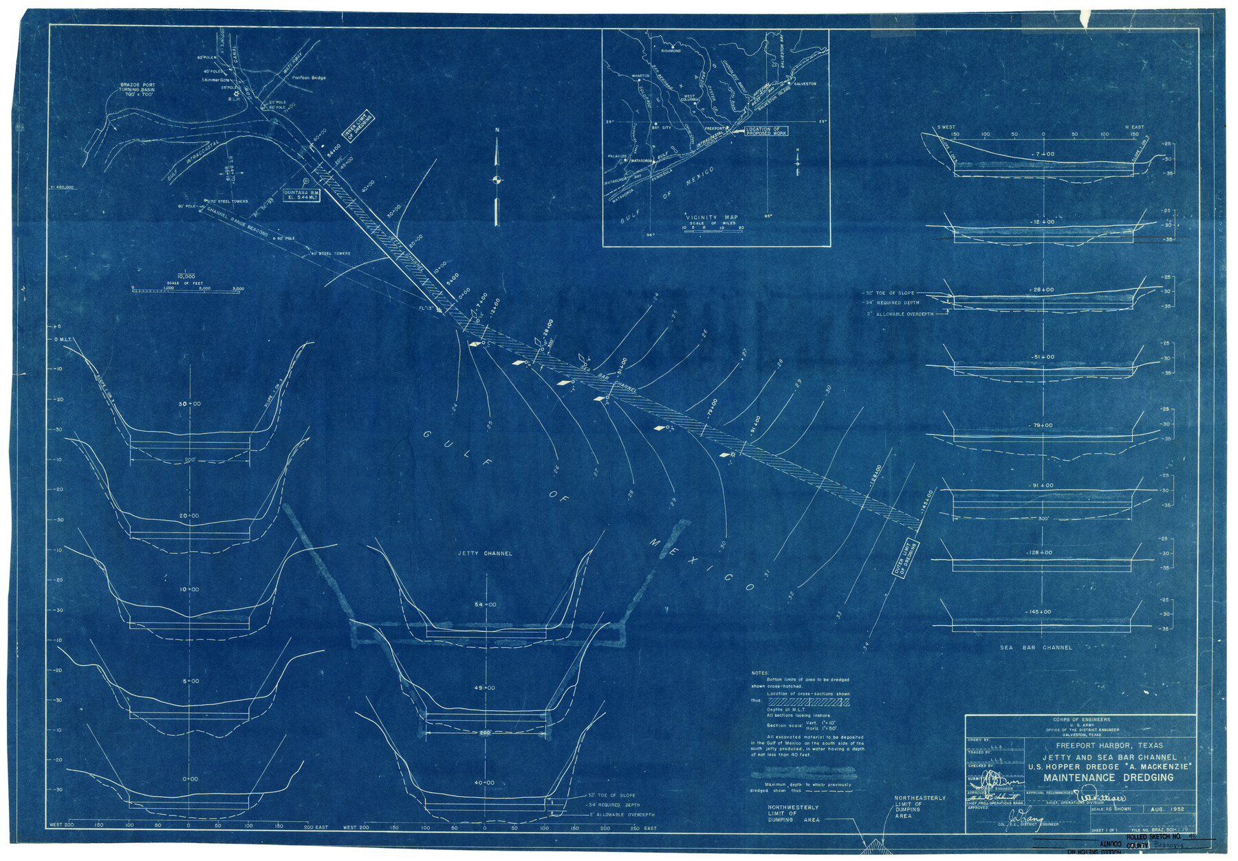
Freeport Harbor, Texas - Jetty & Sea Bar Channel - U.S. Hopper Dredge "A. Mackenzie" - Maintenance Dredging
-
Map/Doc
5181
-
Collection
General Map Collection
-
Object Dates
8/1952 (Creation Date)
2/10/1976 (File Date)
-
People and Organizations
Corps of Engineers (Publisher)
J.D. Lang (Surveyor/Engineer)
-
Counties
Brazoria
-
Subjects
Surveying Rolled Sketch
-
Height x Width
28.6 x 41.3 inches
72.6 x 104.9 cm
-
Medium
blueprint/diazo
Part of: General Map Collection
Callahan County Rolled Sketch 5

Print $40.00
- Digital $50.00
Callahan County Rolled Sketch 5
Size 52.0 x 44.1 inches
Map/Doc 5382
Reeves County Rolled Sketch 37

Print $20.00
- Digital $50.00
Reeves County Rolled Sketch 37
2017
Size 22.9 x 17.1 inches
Map/Doc 95203
University Lands, Blocks 34 to 37, Terrell County

Print $20.00
- Digital $50.00
University Lands, Blocks 34 to 37, Terrell County
1938
Size 32.5 x 40.0 inches
Map/Doc 2417
Eastland County Rolled Sketch 25

Print $20.00
- Digital $50.00
Eastland County Rolled Sketch 25
1990
Size 36.9 x 47.7 inches
Map/Doc 8831
Hudspeth County Working Sketch 48

Print $20.00
- Digital $50.00
Hudspeth County Working Sketch 48
1984
Size 36.6 x 46.3 inches
Map/Doc 66333
Motley County Sketch File 38 (N)

Print $106.00
- Digital $50.00
Motley County Sketch File 38 (N)
1910
Size 14.4 x 8.8 inches
Map/Doc 32086
Hamilton County Rolled Sketch 7

Print $20.00
- Digital $50.00
Hamilton County Rolled Sketch 7
1927
Size 32.2 x 38.4 inches
Map/Doc 6057
Hays County Rolled Sketch 19

Print $20.00
- Digital $50.00
Hays County Rolled Sketch 19
1887
Size 26.7 x 22.3 inches
Map/Doc 6175
Val Verde County Working Sketch 7

Print $20.00
- Digital $50.00
Val Verde County Working Sketch 7
1915
Size 21.9 x 19.5 inches
Map/Doc 72142
Wharton County Working Sketch 11

Print $20.00
- Digital $50.00
Wharton County Working Sketch 11
1976
Size 42.2 x 40.8 inches
Map/Doc 72475
Gonzales County Working Sketch 4a

Print $20.00
- Digital $50.00
Gonzales County Working Sketch 4a
1979
Size 30.9 x 32.2 inches
Map/Doc 63219

You may also like
Current Miscellaneous File 62

Print $64.00
- Digital $50.00
Current Miscellaneous File 62
Size 10.1 x 6.9 inches
Map/Doc 74068
Jim Wells County Working Sketch 2

Print $20.00
- Digital $50.00
Jim Wells County Working Sketch 2
1931
Size 17.0 x 18.0 inches
Map/Doc 66600
Concho County Sketch File 51

Print $24.00
- Digital $50.00
Concho County Sketch File 51
1971
Size 11.1 x 8.6 inches
Map/Doc 19218
McMullen County Working Sketch 14

Print $20.00
- Digital $50.00
McMullen County Working Sketch 14
1938
Size 28.6 x 37.1 inches
Map/Doc 70715
Burleson County Working Sketch 34

Print $20.00
- Digital $50.00
Burleson County Working Sketch 34
1981
Size 20.0 x 12.2 inches
Map/Doc 67753
Mitchell County Boundary File 1a

Print $32.00
- Digital $50.00
Mitchell County Boundary File 1a
Size 13.4 x 8.6 inches
Map/Doc 57344
Comanche County Sketch File 23

Print $4.00
- Digital $50.00
Comanche County Sketch File 23
Size 8.3 x 7.5 inches
Map/Doc 19111
Wichita County Sketch File 20

Print $20.00
- Digital $50.00
Wichita County Sketch File 20
Size 12.0 x 22.5 inches
Map/Doc 12683
Angelina County Working Sketch 24

Print $20.00
- Digital $50.00
Angelina County Working Sketch 24
1954
Size 27.0 x 23.0 inches
Map/Doc 67106
Fort Bend County Working Sketch 15

Print $20.00
- Digital $50.00
Fort Bend County Working Sketch 15
1950
Size 22.5 x 14.7 inches
Map/Doc 69221

