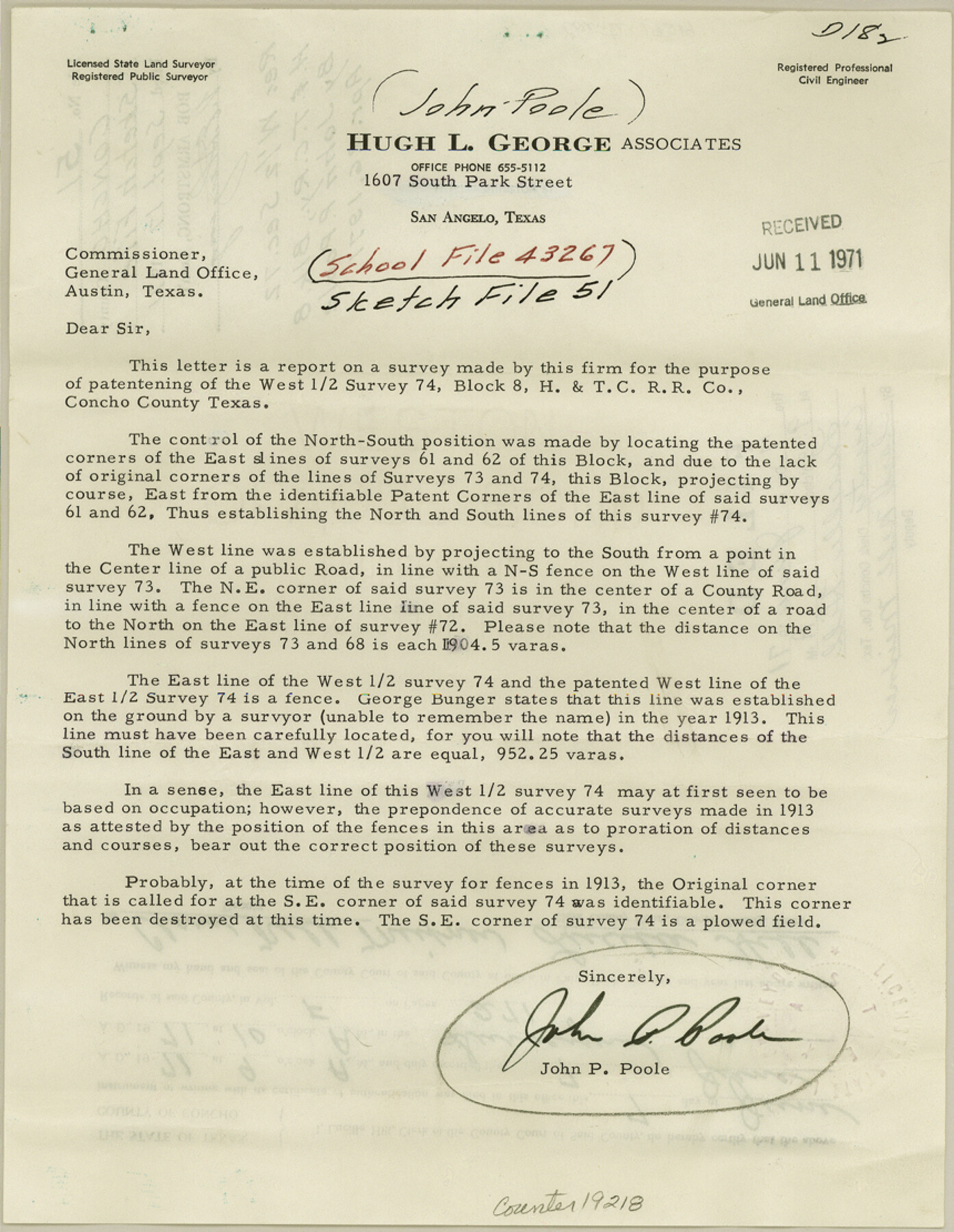
Concho County Sketch File 51
[Report regarding west half of section 72, H. & T. C. RR. Co. Block 8]
-
Map/Doc
19218
-
Collection
General Map Collection
-
Object Dates
1971/4/26 (Creation Date)
1971/9/17 (File Date)
1971/4/20 (Survey Date)
-
People and Organizations
John P. Poole (Surveyor/Engineer)
-
Counties
Concho
-
Subjects
Surveying Sketch File
-
Height x Width
11.1 x 8.6 inches
28.2 x 21.8 cm
-
Medium
paper, photocopy
-
Scale
1:500
-
Features
[Road to] Fort McKavett
[Road to] Eden
Part of: General Map Collection
Van Zandt County Sketch File 40a

Print $4.00
- Digital $50.00
Van Zandt County Sketch File 40a
1872
Size 8.2 x 13.0 inches
Map/Doc 39488
Harris County Working Sketch 100

Print $20.00
- Digital $50.00
Harris County Working Sketch 100
1979
Size 29.9 x 31.3 inches
Map/Doc 65992
Flight Mission No. BRA-7M, Frame 141, Jefferson County

Print $20.00
- Digital $50.00
Flight Mission No. BRA-7M, Frame 141, Jefferson County
1953
Size 18.6 x 22.4 inches
Map/Doc 85535
Pecos County Rolled Sketch 62

Print $20.00
- Digital $50.00
Pecos County Rolled Sketch 62
1927
Size 44.2 x 39.4 inches
Map/Doc 9698
Fractional Township No. 8 South Range No. 22 East of the Indian Meridian, Indian Territory

Print $20.00
- Digital $50.00
Fractional Township No. 8 South Range No. 22 East of the Indian Meridian, Indian Territory
1897
Size 19.2 x 24.2 inches
Map/Doc 75239
Controlled Mosaic by Jack Amman Photogrammetric Engineers, Inc - Sheet 43

Print $20.00
- Digital $50.00
Controlled Mosaic by Jack Amman Photogrammetric Engineers, Inc - Sheet 43
1954
Size 20.0 x 24.0 inches
Map/Doc 83502
Shelby County Rolled Sketch 20

Print $20.00
- Digital $50.00
Shelby County Rolled Sketch 20
1983
Size 24.7 x 37.2 inches
Map/Doc 7785
Flight Mission No. DQN-1K, Frame 141, Calhoun County

Print $20.00
- Digital $50.00
Flight Mission No. DQN-1K, Frame 141, Calhoun County
1953
Size 18.5 x 22.1 inches
Map/Doc 84204
Subdivision Plat of Blue Ridge State Farm Showing 18 Tracts

Print $20.00
- Digital $50.00
Subdivision Plat of Blue Ridge State Farm Showing 18 Tracts
Size 27.0 x 27.4 inches
Map/Doc 62978
Jones County Sketch File 3

Print $4.00
- Digital $50.00
Jones County Sketch File 3
1854
Size 13.3 x 8.0 inches
Map/Doc 28488
Falls County Sketch File 11a

Print $8.00
- Digital $50.00
Falls County Sketch File 11a
1871
Size 12.9 x 8.2 inches
Map/Doc 22358
Newton County Rolled Sketch 25

Print $20.00
- Digital $50.00
Newton County Rolled Sketch 25
1893
Size 22.3 x 18.6 inches
Map/Doc 6852
You may also like
Missouri, Kansas, and Texas Railway

Print $20.00
Missouri, Kansas, and Texas Railway
1878
Size 16.5 x 12.2 inches
Map/Doc 76188
Live Oak County Working Sketch 39

Print $40.00
- Digital $50.00
Live Oak County Working Sketch 39
2006
Size 36.4 x 48.6 inches
Map/Doc 94156
Plat in Pecos County, Texas

Print $40.00
- Digital $50.00
Plat in Pecos County, Texas
1927
Size 58.3 x 37.9 inches
Map/Doc 89877
Topographic Map of Texas and Oklahoma Boundary, Fort Augur Area

Print $20.00
Topographic Map of Texas and Oklahoma Boundary, Fort Augur Area
1924
Size 22.1 x 38.3 inches
Map/Doc 79752
Bowie County Working Sketch 12

Print $20.00
- Digital $50.00
Bowie County Working Sketch 12
1959
Size 31.3 x 23.3 inches
Map/Doc 67416
Limestone County Working Sketch 27

Print $20.00
- Digital $50.00
Limestone County Working Sketch 27
2008
Size 34.4 x 35.6 inches
Map/Doc 88767
A Map of the Internal Provinces of New Spain

Print $20.00
A Map of the Internal Provinces of New Spain
1807
Size 18.9 x 19.5 inches
Map/Doc 76234
Right of Way and Track Map, The Missouri, Kansas and Texas Ry. of Texas operated by the Missouri, Kansas and Texas Ry. of Texas, Henrietta Division

Print $40.00
- Digital $50.00
Right of Way and Track Map, The Missouri, Kansas and Texas Ry. of Texas operated by the Missouri, Kansas and Texas Ry. of Texas, Henrietta Division
1918
Size 25.5 x 56.6 inches
Map/Doc 64070
Sutton County Rolled Sketch 55
Print $40.00
- Digital $50.00
Sutton County Rolled Sketch 55
1954
Size 37.5 x 59.0 inches
Map/Doc 9976

Map of Cameron, Hidalgo and half of Starr County of Texas

Print $20.00
- Digital $50.00
Map of Cameron, Hidalgo and half of Starr County of Texas
1942
Size 42.1 x 29.6 inches
Map/Doc 60401
Flight Mission No. DQO-1K, Frame 153, Galveston County

Print $20.00
- Digital $50.00
Flight Mission No. DQO-1K, Frame 153, Galveston County
1952
Size 18.8 x 22.5 inches
Map/Doc 85006