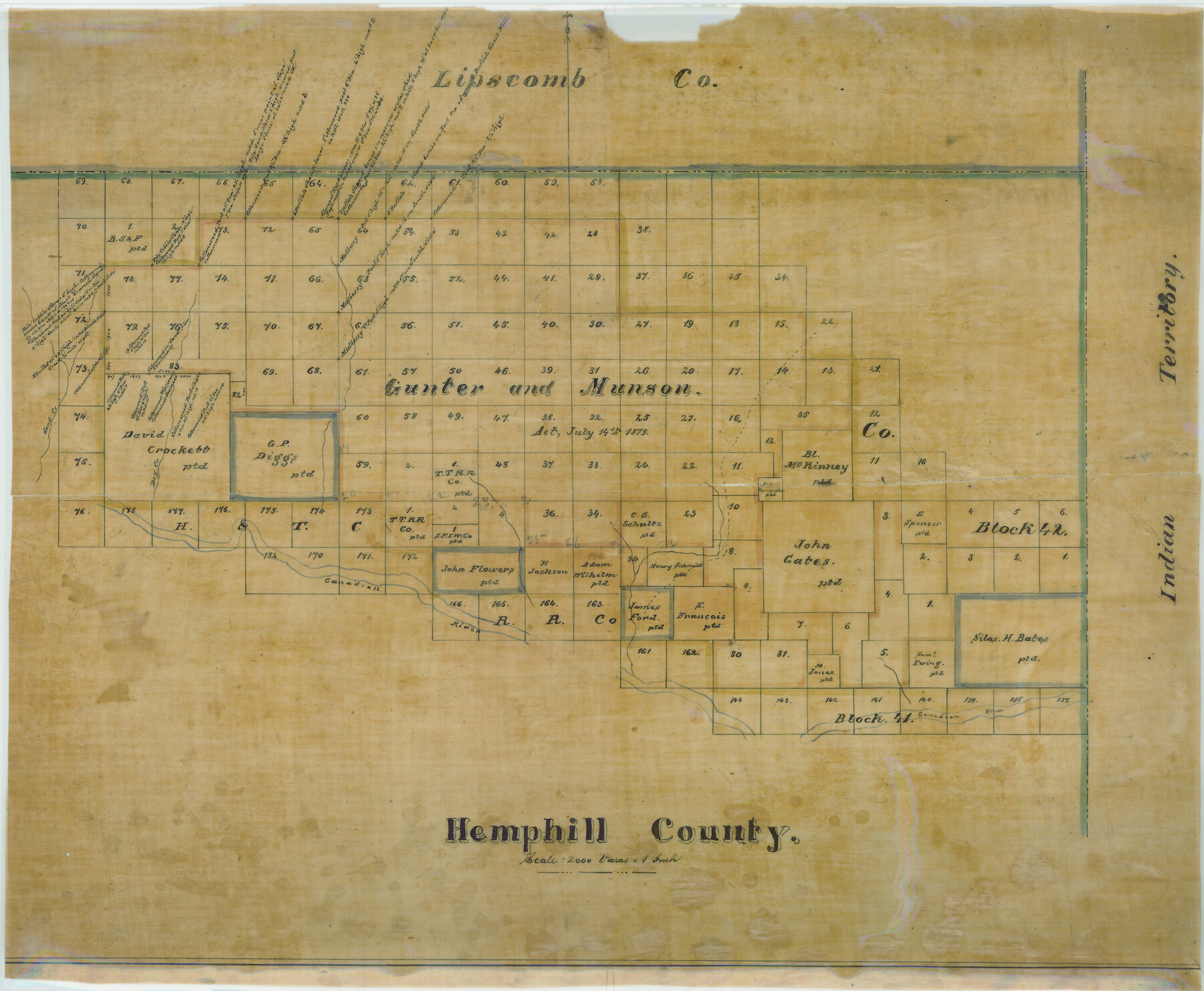
Hemphill County
-
Map/Doc
4389
-
Collection
Maddox Collection
-
Counties
Hemphill Lipscomb
-
Height x Width
20.1 x 24.4 inches
51.1 x 62.0 cm
-
Medium
paper, manuscript
-
Scale
2000 varas = 1 inch
-
Features
Canadian River
Dry Creek
Sand Creek
Part of: Maddox Collection
Red River County, Texas

Print $20.00
- Digital $50.00
Red River County, Texas
1879
Size 29.3 x 21.9 inches
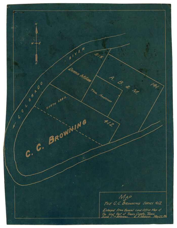
Map/Doc 598
Map of the C.C. Browning survey 412 enlarged from General Land Office map of the west part of Travis County, Texas
Print $3.00
- Digital $50.00
Map of the C.C. Browning survey 412 enlarged from General Land Office map of the west part of Travis County, Texas
1920
Size 11.3 x 9.1 inches
Map/Doc 10752
Swearingen Township situated in Cottle County, Texas

Print $20.00
- Digital $50.00
Swearingen Township situated in Cottle County, Texas
Size 26.4 x 15.7 inches
Map/Doc 4437
Map of Live Oak County, Texas

Print $20.00
- Digital $50.00
Map of Live Oak County, Texas
1911
Size 28.0 x 20.4 inches
Map/Doc 567
Dimmit County, Texas

Print $20.00
- Digital $50.00
Dimmit County, Texas
1879
Size 22.6 x 28.6 inches
Map/Doc 5031
Map of Part of the YL Ranch

Print $20.00
- Digital $50.00
Map of Part of the YL Ranch
1917
Size 29.1 x 27.3 inches
Map/Doc 4442
Map showing surveys in Blocks 45, 3, R & 5T

Print $20.00
- Digital $50.00
Map showing surveys in Blocks 45, 3, R & 5T
1913
Size 30.2 x 37.5 inches
Map/Doc 496
Callahan County, Texas

Print $20.00
- Digital $50.00
Callahan County, Texas
1880
Size 24.1 x 18.5 inches
Map/Doc 89276
Aransas County, Texas

Print $20.00
- Digital $50.00
Aransas County, Texas
1880
Size 19.3 x 20.2 inches
Map/Doc 665
Part of Tom Green County, Texas (No. 3)

Print $20.00
- Digital $50.00
Part of Tom Green County, Texas (No. 3)
1870
Size 22.9 x 17.7 inches
Map/Doc 5047
Sketch in Hardeman Co.

Print $3.00
- Digital $50.00
Sketch in Hardeman Co.
1890
Size 12.4 x 11.0 inches
Map/Doc 75925
Terlingua Special Map, The University of Texas Mineral Survey, Brewster County, Texas

Print $20.00
- Digital $50.00
Terlingua Special Map, The University of Texas Mineral Survey, Brewster County, Texas
1902
Size 20.4 x 22.6 inches
Map/Doc 482
You may also like
Montgomery County Working Sketch 65

Print $20.00
- Digital $50.00
Montgomery County Working Sketch 65
1965
Size 21.5 x 16.7 inches
Map/Doc 71172
Presidio County Rolled Sketch 106

Print $20.00
- Digital $50.00
Presidio County Rolled Sketch 106
1955
Size 23.0 x 36.4 inches
Map/Doc 7387
Flight Mission No. DIX-10P, Frame 151, Aransas County

Print $20.00
- Digital $50.00
Flight Mission No. DIX-10P, Frame 151, Aransas County
1956
Size 18.7 x 22.3 inches
Map/Doc 83953
Hutchinson County Rolled Sketch 40

Print $20.00
- Digital $50.00
Hutchinson County Rolled Sketch 40
1981
Size 25.7 x 37.3 inches
Map/Doc 6304
Culberson County Sketch File 2

Print $20.00
- Digital $50.00
Culberson County Sketch File 2
1882
Size 28.9 x 36.4 inches
Map/Doc 11261
Floyd County Working Sketch Graphic Index

Print $20.00
- Digital $50.00
Floyd County Working Sketch Graphic Index
1933
Size 44.9 x 38.4 inches
Map/Doc 76543
Geological Survey of Texas, First Annual Report, Plate II, Figures 6, 7, 8, 9

Print $20.00
- Digital $50.00
Geological Survey of Texas, First Annual Report, Plate II, Figures 6, 7, 8, 9
Size 17.1 x 18.1 inches
Map/Doc 75114
Stephens County, Texas

Print $20.00
- Digital $50.00
Stephens County, Texas
1870
Size 21.0 x 17.7 inches
Map/Doc 756

Crockett County Rolled Sketch 95

Print $20.00
- Digital $50.00
Crockett County Rolled Sketch 95
1985
Size 24.6 x 28.8 inches
Map/Doc 5634
Americae Sive Novi Orbis, Nova Descriptio

Print $20.00
- Digital $50.00
Americae Sive Novi Orbis, Nova Descriptio
1573
Size 15.6 x 22.3 inches
Map/Doc 95834
Moore County Sketch File 3

Print $20.00
- Digital $50.00
Moore County Sketch File 3
Size 17.2 x 19.3 inches
Map/Doc 42126