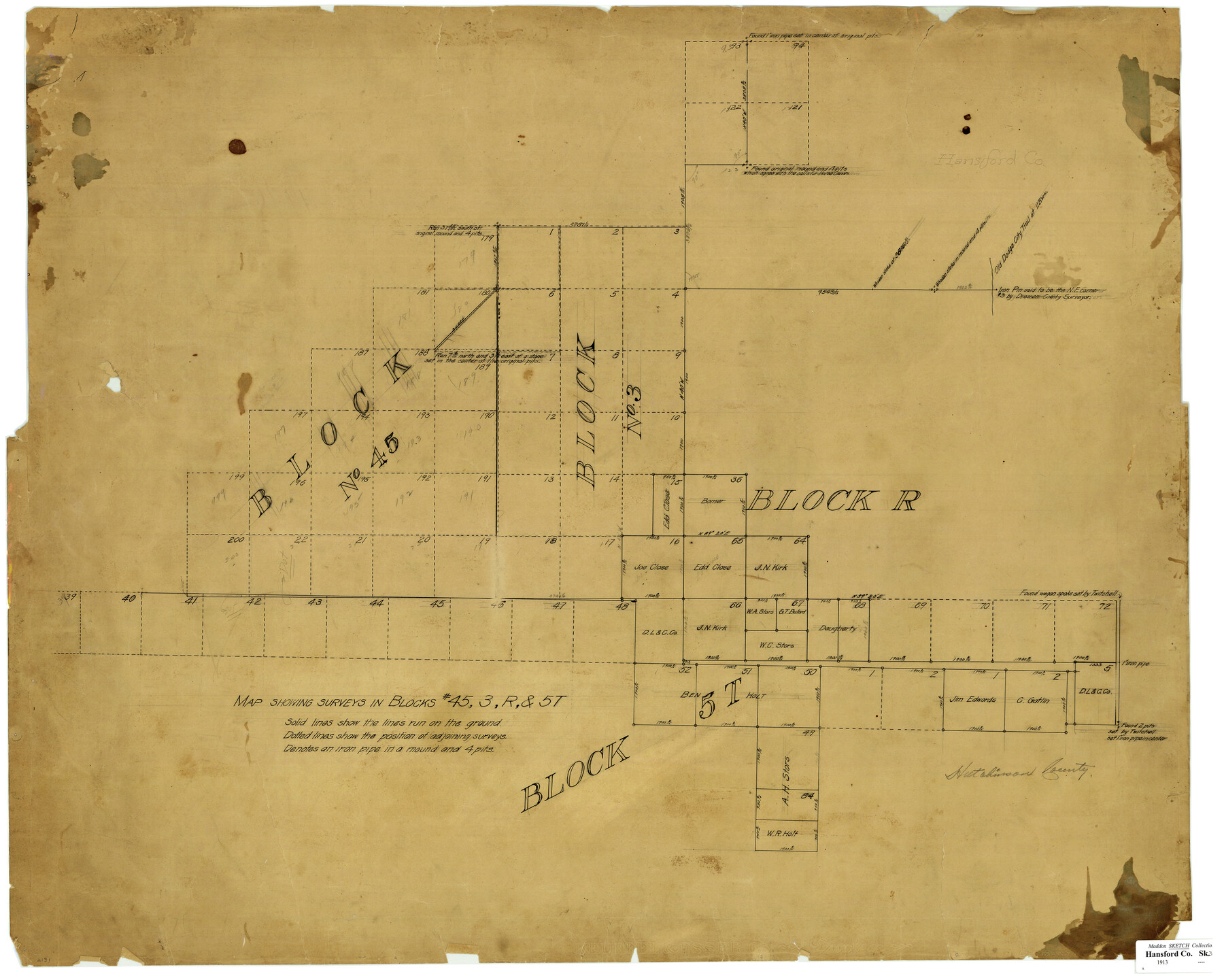
Map showing surveys in Blocks 45, 3, R & 5T
-
Map/Doc
496
-
Collection
Maddox Collection
-
Object Dates
8/1913 (Creation Date)
-
People and Organizations
Joe Close (Surveyor/Engineer)
-
Counties
Hansford Hutchinson
-
Height x Width
30.2 x 37.5 inches
76.7 x 95.3 cm
-
Medium
paper, manuscript
-
Comments
Written note on the back provides the apparent date and surveyor name.
-
Features
Old Dodge City Trail
Part of: Maddox Collection
King County, Texas

Print $20.00
- Digital $50.00
King County, Texas
1880
Size 20.0 x 19.4 inches
Map/Doc 737
Midland County, Texas

Print $20.00
- Digital $50.00
Midland County, Texas
1888
Size 22.4 x 17.5 inches
Map/Doc 653
Graham's Addition Being a Subdivision of a Portion of Lot No. 1 of Spear League

Print $20.00
- Digital $50.00
Graham's Addition Being a Subdivision of a Portion of Lot No. 1 of Spear League
1914
Size 13.6 x 33.0 inches
Map/Doc 542
Map of Tyler County, Texas

Print $20.00
- Digital $50.00
Map of Tyler County, Texas
1879
Size 28.6 x 22.8 inches
Map/Doc 720
Austin and Surrounding Properties
.tif.jpg)
Print $20.00
- Digital $50.00
Austin and Surrounding Properties
1891
Size 42.9 x 32.1 inches
Map/Doc 421
Map of Bandera County, Texas

Print $20.00
- Digital $50.00
Map of Bandera County, Texas
1879
Size 19.6 x 32.6 inches
Map/Doc 691
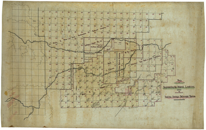
Map Representing the Original Locations of Various Surveys Deliniated Thereon
Print $40.00
- Digital $50.00
Map Representing the Original Locations of Various Surveys Deliniated Thereon
1890
Size 40.8 x 62.0 inches
Map/Doc 469
Motley County, Texas

Print $20.00
- Digital $50.00
Motley County, Texas
1883
Size 23.6 x 20.7 inches
Map/Doc 743
Revised Sectional Map No. 3 showing land surveys in counties of Loving, Reeves and Culberson and portions of Winkler, Ward, Pecos and Jeff Davis, Texas

Print $20.00
- Digital $50.00
Revised Sectional Map No. 3 showing land surveys in counties of Loving, Reeves and Culberson and portions of Winkler, Ward, Pecos and Jeff Davis, Texas
Size 19.0 x 24.7 inches
Map/Doc 4478
Map of SW portion of Hale Co., Texas

Print $3.00
- Digital $50.00
Map of SW portion of Hale Co., Texas
Size 12.7 x 10.8 inches
Map/Doc 518
Map of part of Waller County

Print $20.00
- Digital $50.00
Map of part of Waller County
Size 16.3 x 13.5 inches
Map/Doc 685
Hansford County, Texas

Print $20.00
- Digital $50.00
Hansford County, Texas
1888
Size 22.6 x 18.6 inches
Map/Doc 5033
You may also like
Andrews County Sketch File 14

Print $48.00
- Digital $50.00
Andrews County Sketch File 14
1887
Size 8.0 x 8.4 inches
Map/Doc 12872
Jim Wells County Sketch File 2

Print $6.00
- Digital $50.00
Jim Wells County Sketch File 2
1931
Size 11.1 x 8.7 inches
Map/Doc 28424
[Sketch showing T. &P. R. R. Co. Blks. 32, 33, 34 Township 4N, and J. Poitevent Block I]
![89629, [Sketch showing T. &P. R. R. Co. Blks. 32, 33, 34 Township 4N, and J. Poitevent Block I], Twichell Survey Records](https://historictexasmaps.com/wmedia_w700/maps/89629-1.tif.jpg)
Print $40.00
- Digital $50.00
[Sketch showing T. &P. R. R. Co. Blks. 32, 33, 34 Township 4N, and J. Poitevent Block I]
Size 19.2 x 49.8 inches
Map/Doc 89629
McMullen County Working Sketch 49

Print $20.00
- Digital $50.00
McMullen County Working Sketch 49
1983
Size 12.8 x 14.6 inches
Map/Doc 70750
Val Verde County Sketch File Z23

Print $6.00
- Digital $50.00
Val Verde County Sketch File Z23
1919
Size 7.3 x 8.8 inches
Map/Doc 39166
Map of Llano County, Texas

Print $20.00
Map of Llano County, Texas
1879
Size 23.1 x 21.2 inches
Map/Doc 88970
Orange County Rolled Sketch CR

Print $20.00
- Digital $50.00
Orange County Rolled Sketch CR
Size 39.4 x 31.5 inches
Map/Doc 9653
Map of the chief part of the Southern States and part of the Western engraved to illustrate Mitchell's school and family geography

Print $20.00
- Digital $50.00
Map of the chief part of the Southern States and part of the Western engraved to illustrate Mitchell's school and family geography
1839
Size 11.8 x 17.5 inches
Map/Doc 93497
Coryell County Sketch File 22

Print $20.00
- Digital $50.00
Coryell County Sketch File 22
1943
Size 24.8 x 18.2 inches
Map/Doc 11186
Wise County Sketch File 45

Print $4.00
- Digital $50.00
Wise County Sketch File 45
Size 8.6 x 14.2 inches
Map/Doc 40605
Pecos County Rolled Sketch 173

Print $20.00
- Digital $50.00
Pecos County Rolled Sketch 173
Size 32.2 x 35.6 inches
Map/Doc 9751
Chambers County NRC Article 33.136 Sketch 9

Print $24.00
- Digital $50.00
Chambers County NRC Article 33.136 Sketch 9
2014
Size 17.7 x 24.0 inches
Map/Doc 94747