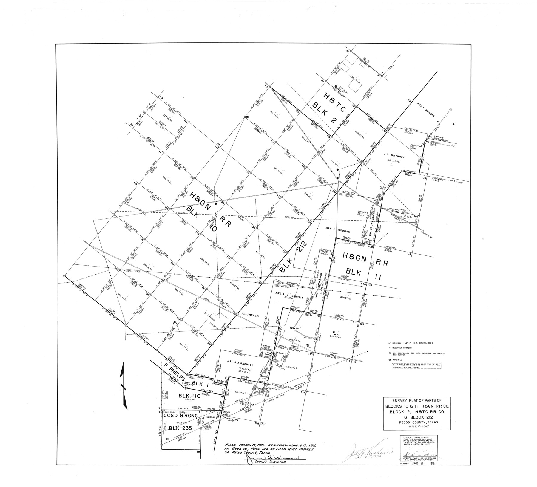
Pecos County Rolled Sketch 173
Survey plat of parts of Blocks 10 & 11, H. & G. N. R.R. Co., Block 2, H. & T. C. R.R. Co. & Block 212, Pecos County, Texas
-
Map/Doc
9751
-
Collection
General Map Collection
-
Object Dates
1972/9/21 (Revision Date)
1976/4/14 (File Date)
-
People and Organizations
Jos. W. Luchini (Surveyor/Engineer)
-
Counties
Pecos
-
Subjects
Surveying Rolled Sketch
-
Height x Width
32.2 x 35.6 inches
81.8 x 90.4 cm
-
Scale
1" = 2000 feet
Part of: General Map Collection
Flight Mission No. CRK-3P, Frame 70, Refugio County

Print $20.00
- Digital $50.00
Flight Mission No. CRK-3P, Frame 70, Refugio County
1956
Size 18.6 x 22.5 inches
Map/Doc 86912
Kimble County Rolled Sketch 32

Print $20.00
- Digital $50.00
Kimble County Rolled Sketch 32
1973
Size 23.1 x 19.6 inches
Map/Doc 6522
Kerr County Working Sketch 30

Print $20.00
- Digital $50.00
Kerr County Working Sketch 30
1973
Size 29.8 x 28.9 inches
Map/Doc 70061
Jeff Davis County Rolled Sketch 10

Print $6.00
- Digital $50.00
Jeff Davis County Rolled Sketch 10
1906
Size 29.6 x 30.1 inches
Map/Doc 6363
Duval County Rolled Sketch 15

Print $20.00
- Digital $50.00
Duval County Rolled Sketch 15
1940
Size 38.7 x 27.1 inches
Map/Doc 5737
Bosque County Sketch File 2

Print $4.00
- Digital $50.00
Bosque County Sketch File 2
1847
Size 7.8 x 12.4 inches
Map/Doc 14740
Liberty County Rolled Sketch JLW

Print $40.00
- Digital $50.00
Liberty County Rolled Sketch JLW
1935
Size 28.0 x 85.5 inches
Map/Doc 9665
Jeff Davis County Working Sketch 13

Print $20.00
- Digital $50.00
Jeff Davis County Working Sketch 13
1949
Size 24.5 x 32.7 inches
Map/Doc 66508
Bee County Working Sketch 29a

Print $20.00
- Digital $50.00
Bee County Working Sketch 29a
1988
Size 36.3 x 43.1 inches
Map/Doc 67279
San Patricio County Sketch File 4

Print $40.00
- Digital $50.00
San Patricio County Sketch File 4
Size 16.9 x 30.5 inches
Map/Doc 12283
Flight Mission No. CUG-3P, Frame 134, Kleberg County

Print $20.00
- Digital $50.00
Flight Mission No. CUG-3P, Frame 134, Kleberg County
1956
Size 18.5 x 22.3 inches
Map/Doc 86269
Maverick County Sketch File 15

Print $8.00
- Digital $50.00
Maverick County Sketch File 15
Size 14.2 x 8.6 inches
Map/Doc 31113
You may also like
Sutton County Sketch File 5

Print $40.00
- Digital $50.00
Sutton County Sketch File 5
Size 14.0 x 17.3 inches
Map/Doc 37356
Brown County Sketch File 10

Print $40.00
- Digital $50.00
Brown County Sketch File 10
1868
Size 17.4 x 22.3 inches
Map/Doc 11019
Fractional Township No. 1N and Township No. 2N R. No. 2E, Deaf Smith and Parmer Counties comprising Capitol Leagues 439 and 452 and parts of Capitol Leagues 431, 432, 433, 438, 440, 451, 453, 458, 459, and 460

Print $20.00
- Digital $50.00
Fractional Township No. 1N and Township No. 2N R. No. 2E, Deaf Smith and Parmer Counties comprising Capitol Leagues 439 and 452 and parts of Capitol Leagues 431, 432, 433, 438, 440, 451, 453, 458, 459, and 460
1906
Size 27.1 x 22.4 inches
Map/Doc 93966
Flight Mission No. BRA-6M, Frame 73, Jefferson County

Print $20.00
- Digital $50.00
Flight Mission No. BRA-6M, Frame 73, Jefferson County
1953
Size 18.6 x 22.3 inches
Map/Doc 85417
Culberson County Sketch File 40

Print $6.00
- Digital $50.00
Culberson County Sketch File 40
Size 24.8 x 35.2 inches
Map/Doc 11275

Matagorda County Sketch File 42b

Print $12.00
- Digital $50.00
Matagorda County Sketch File 42b
1913
Size 11.2 x 8.7 inches
Map/Doc 30862
Map of Tom Green County

Print $20.00
- Digital $50.00
Map of Tom Green County
1892
Size 42.9 x 46.2 inches
Map/Doc 78390
Reagan County Sketch File 31

Print $20.00
- Digital $50.00
Reagan County Sketch File 31
1951
Size 24.9 x 20.5 inches
Map/Doc 12227
Comal County State Real Property Sketch 1

Print $134.00
- Digital $50.00
Comal County State Real Property Sketch 1
2006
Size 23.8 x 35.4 inches
Map/Doc 88635
Phelps and Watson's Historical and Military Map of the Border and Southern States

Print $20.00
Phelps and Watson's Historical and Military Map of the Border and Southern States
1863
Size 25.5 x 36.3 inches
Map/Doc 76202
Map of Cherokee County

Print $20.00
- Digital $50.00
Map of Cherokee County
1851
Size 24.6 x 18.3 inches
Map/Doc 3386