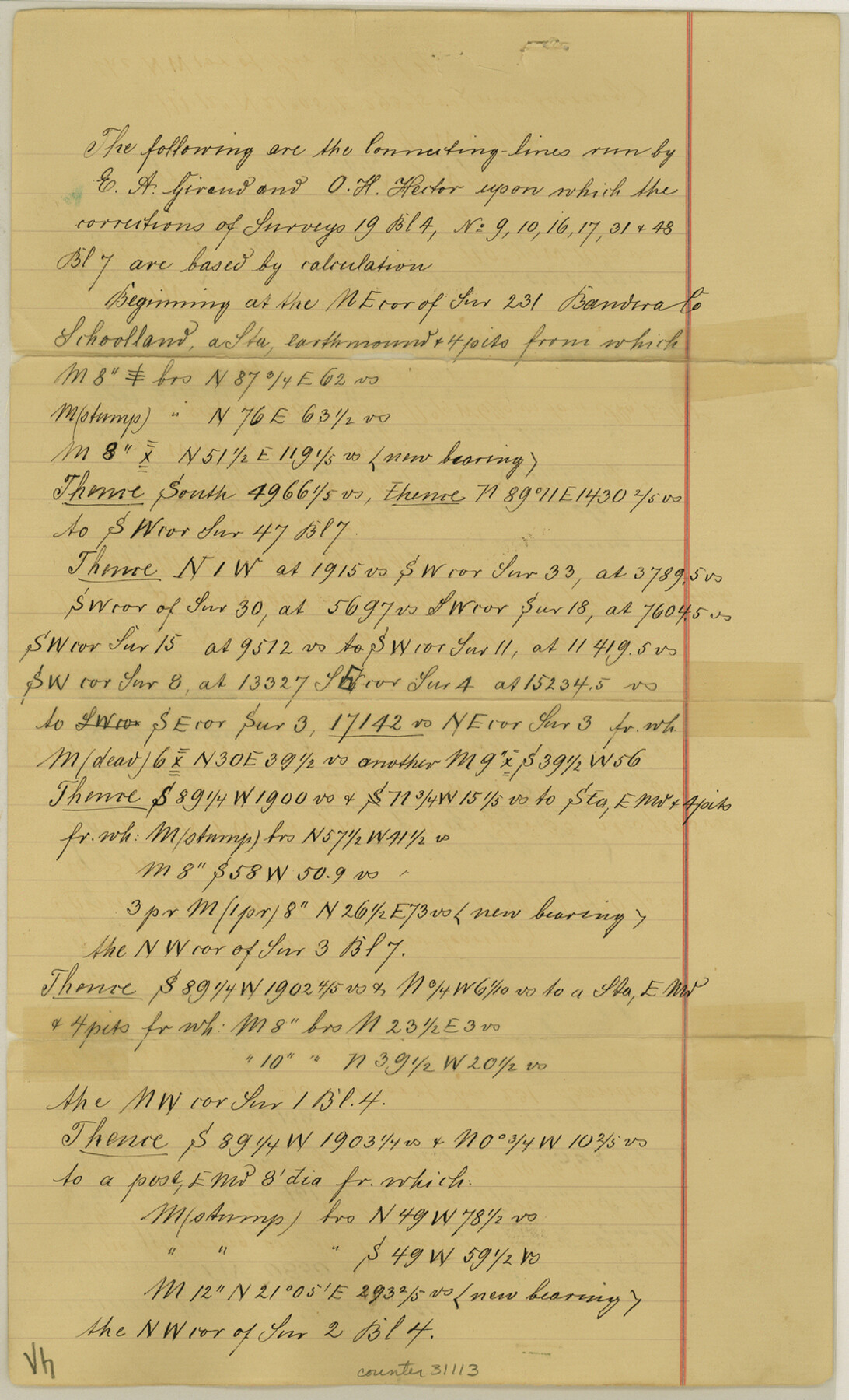
Maverick County Sketch File 15
[Connecting line from northeast corner of survey 231, Bandera County School Land]
- 
                          Map/Doc31113
- 
                            CollectionGeneral Map Collection
- 
                            Object Dates3/16/1887 (File Date)
- 
                            People and OrganizationsE.A. Giraud (Surveyor/Engineer)O.H. Hector (Surveyor/Engineer)
- 
                            CountiesMaverick
- 
                            SubjectsSurveying Sketch File
- 
                            Height x Width14.2 x 8.6 inches36.1 x 21.8 cm
- 
                            Mediumpaper, manuscript
Part of: General Map Collection
            Potter County Boundary File 3b


                                            Print $12.00                    
                                             -                         Digital $50.00                                    
                Potter County Boundary File 3b
Size 9.8 x 6.4 inches
                                Map/Doc 57979
            
            Right-of-Way and Track Map, Houston and Brazos Valley Ry. Co. operated by the Houston and Brazos Valley Ry. Co.


                                            Print $40.00                    
                                             -                         Digital $50.00                                    
                Right-of-Way and Track Map, Houston and Brazos Valley Ry. Co. operated by the Houston and Brazos Valley Ry. Co.
1918
Size 24.9 x 56.6 inches
                                Map/Doc 64606
            
            Panola County Sketch File 1a


                                            Print $4.00                    
                                             -                         Digital $50.00                                    
                Panola County Sketch File 1a
1855
Size 12.7 x 7.9 inches
                                Map/Doc 33445
            
            Webb County Boundary File 3b


                                            Print $82.00                    
                                             -                         Digital $50.00                                    
                Webb County Boundary File 3b
Size 20.3 x 50.8 inches
                                Map/Doc 59758
            
            United States - Gulf Coast - From Latitude 26° 33' to the Rio Grande Texas


                                            Print $20.00                    
                                             -                         Digital $50.00                                    
                United States - Gulf Coast - From Latitude 26° 33' to the Rio Grande Texas
1913
Size 18.5 x 27.6 inches
                                Map/Doc 72841
            
            Navigation Maps of Gulf Intracoastal Waterway, Port Arthur to Brownsville, Texas


                                            Print $4.00                    
                                             -                         Digital $50.00                                    
                Navigation Maps of Gulf Intracoastal Waterway, Port Arthur to Brownsville, Texas
1951
Size 16.7 x 21.5 inches
                                Map/Doc 65441
            
            Anderson County Rolled Sketch 12


                                            Print $20.00                    
                                             -                         Digital $50.00                                    
                Anderson County Rolled Sketch 12
1954
Size 24.6 x 21.3 inches
                                Map/Doc 77157
            
            PSL Field Notes for Block CS in Hartley County


            PSL Field Notes for Block CS in Hartley County
Map/Doc 81656
            
            Flight Mission No. BQY-4M, Frame 33, Harris County


                                            Print $20.00                    
                                             -                         Digital $50.00                                    
                Flight Mission No. BQY-4M, Frame 33, Harris County
1953
Size 18.7 x 22.4 inches
                                Map/Doc 85248
            
            Hutchinson County Sketch File 1


                                            Print $22.00                    
                                             -                         Digital $50.00                                    
                Hutchinson County Sketch File 1
Size 8.9 x 7.8 inches
                                Map/Doc 27172
            
            Donley County Sketch File 6


                                            Print $16.00                    
                                             -                         Digital $50.00                                    
                Donley County Sketch File 6
1881
Size 12.9 x 8.5 inches
                                Map/Doc 21230
            You may also like
            Pecos County Working Sketch 94


                                            Print $20.00                    
                                             -                         Digital $50.00                                    
                Pecos County Working Sketch 94
1968
Size 37.8 x 38.7 inches
                                Map/Doc 71567
            
            Val Verde County Sketch File XXX6


                                            Print $6.00                    
                                             -                         Digital $50.00                                    
                Val Verde County Sketch File XXX6
Size 17.0 x 9.9 inches
                                Map/Doc 39102
            
            Bowie County Working Sketch 29


                                            Print $20.00                    
                                             -                         Digital $50.00                                    
                Bowie County Working Sketch 29
1991
Size 36.9 x 47.7 inches
                                Map/Doc 67433
            
            San Patricio County Sketch File 16


                                            Print $4.00                    
                                    
                San Patricio County Sketch File 16
1880
Size 12.9 x 8.0 inches
                                Map/Doc 36064
            
            Baylor County Sketch File 11C


                                            Print $20.00                    
                                             -                         Digital $50.00                                    
                Baylor County Sketch File 11C
1892
Map/Doc 88491
            
            Atascosa County Working Sketch 26


                                            Print $20.00                    
                                             -                         Digital $50.00                                    
                Atascosa County Working Sketch 26
1960
Size 46.9 x 43.7 inches
                                Map/Doc 67222
            
            Taylor County


                                            Print $20.00                    
                                             -                         Digital $50.00                                    
                Taylor County
1934
Size 42.0 x 36.6 inches
                                Map/Doc 77432
            
            Brewster County Working Sketch 35


                                            Print $20.00                    
                                             -                         Digital $50.00                                    
                Brewster County Working Sketch 35
1943
Size 21.0 x 19.4 inches
                                Map/Doc 67569
            
            Edwards County Working Sketch 25


                                            Print $20.00                    
                                             -                         Digital $50.00                                    
                Edwards County Working Sketch 25
1942
Size 22.6 x 20.8 inches
                                Map/Doc 68901
            
            Right of Way and Track Map, Galveston, Harrisburg & San Antonio Ry. operated by the T. & N. O. R.R. Co., Victoria Division, Rosenberg to Beeville


                                            Print $40.00                    
                                             -                         Digital $50.00                                    
                Right of Way and Track Map, Galveston, Harrisburg & San Antonio Ry. operated by the T. & N. O. R.R. Co., Victoria Division, Rosenberg to Beeville
1918
Size 25.1 x 57.9 inches
                                Map/Doc 76157
            
            Wichita County Sketch File 22


                                            Print $10.00                    
                                             -                         Digital $50.00                                    
                Wichita County Sketch File 22
1911
Size 11.3 x 8.6 inches
                                Map/Doc 40104
            
            Madison County Working Sketch 4


                                            Print $20.00                    
                                             -                         Digital $50.00                                    
                Madison County Working Sketch 4
1973
Size 12.7 x 12.9 inches
                                Map/Doc 70766
             
                            