Duval County Sketch File 64
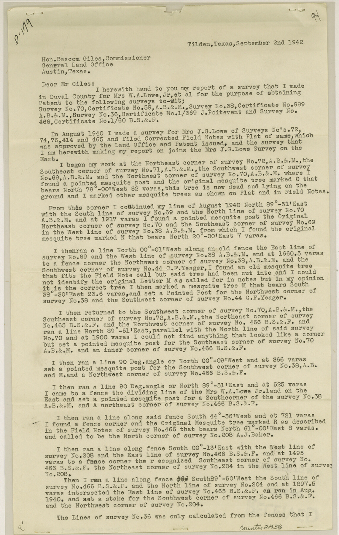
[Report of survey made for the purpose of obtaining a patent for survey 70, A. B. & M., survey 38, A. B. & M., survey 36, J. Poitevent and survey 466, B. S. & F.]
-
Map/Doc
21438
-
Collection
General Map Collection
-
Object Dates
1942/9/2 (Creation Date)
1942/10/1 (File Date)
-
People and Organizations
W.S. Goff (Surveyor/Engineer)
-
Counties
Duval McMullen
-
Subjects
Surveying Sketch File
-
Height x Width
14.2 x 9.0 inches
36.1 x 22.9 cm
-
Medium
paper, print
-
Comments
See Duval County Rolled Sketch 22 (5741) for sketch.
Related maps
Duval County Rolled Sketch 22

Print $20.00
- Digital $50.00
Duval County Rolled Sketch 22
1942
Size 19.5 x 30.0 inches
Map/Doc 5741
Part of: General Map Collection
Ward County Working Sketch 49

Print $40.00
- Digital $50.00
Ward County Working Sketch 49
1974
Size 54.8 x 37.1 inches
Map/Doc 72355
Midland County Working Sketch 3

Print $20.00
- Digital $50.00
Midland County Working Sketch 3
Size 19.5 x 35.2 inches
Map/Doc 70983
Lee County State Real Property Sketch 1

Print $20.00
- Digital $50.00
Lee County State Real Property Sketch 1
2010
Size 24.3 x 35.9 inches
Map/Doc 89286
Kimble County Working Sketch 92

Print $20.00
- Digital $50.00
Kimble County Working Sketch 92
1979
Size 24.0 x 30.6 inches
Map/Doc 70160
Coleman County Sketch File 28

Print $6.00
- Digital $50.00
Coleman County Sketch File 28
1873
Size 10.2 x 15.8 inches
Map/Doc 18716
Neches River, City of Lufkin

Print $20.00
- Digital $50.00
Neches River, City of Lufkin
1940
Size 37.5 x 29.7 inches
Map/Doc 65081
Webb County Working Sketch 54

Print $20.00
- Digital $50.00
Webb County Working Sketch 54
1954
Size 43.1 x 33.6 inches
Map/Doc 72420
Culberson County Working Sketch 71

Print $40.00
- Digital $50.00
Culberson County Working Sketch 71
1975
Size 48.4 x 32.9 inches
Map/Doc 68525
Kimble County Rolled Sketch 17

Print $20.00
- Digital $50.00
Kimble County Rolled Sketch 17
Size 19.7 x 20.5 inches
Map/Doc 6509
Sutton County Working Sketch 47

Print $20.00
- Digital $50.00
Sutton County Working Sketch 47
1954
Size 34.3 x 21.3 inches
Map/Doc 62390
Llano County Sketch File 16

Print $12.00
- Digital $50.00
Llano County Sketch File 16
1905
Size 12.3 x 11.3 inches
Map/Doc 30392
Flight Mission No. DQO-8K, Frame 63, Galveston County

Print $20.00
- Digital $50.00
Flight Mission No. DQO-8K, Frame 63, Galveston County
1952
Size 18.6 x 22.3 inches
Map/Doc 85167
You may also like
Andrews County Rolled Sketch 42

Print $20.00
- Digital $50.00
Andrews County Rolled Sketch 42
Size 27.3 x 36.0 inches
Map/Doc 77182
[Surveys in Austin's Colony along the east bank of the Navidad River]
![78488, [Surveys in Austin's Colony along the east bank of the Navidad River], General Map Collection](https://historictexasmaps.com/wmedia_w700/maps/78488.tif.jpg)
Print $20.00
- Digital $50.00
[Surveys in Austin's Colony along the east bank of the Navidad River]
1827
Size 20.3 x 16.1 inches
Map/Doc 78488
Blanco County Rolled Sketch 15

Print $20.00
- Digital $50.00
Blanco County Rolled Sketch 15
Size 12.9 x 13.7 inches
Map/Doc 5151
Kleberg County Rolled Sketch 10-5

Print $20.00
- Digital $50.00
Kleberg County Rolled Sketch 10-5
1951
Size 37.6 x 35.6 inches
Map/Doc 9394
Johnson County

Print $20.00
- Digital $50.00
Johnson County
1943
Size 42.4 x 39.0 inches
Map/Doc 1868
Menard County Working Sketch 8

Print $20.00
- Digital $50.00
Menard County Working Sketch 8
1928
Size 19.2 x 15.7 inches
Map/Doc 70955
Hudspeth County Working Sketch 40

Print $20.00
- Digital $50.00
Hudspeth County Working Sketch 40
1981
Size 35.6 x 43.8 inches
Map/Doc 66325
El Paso County Boundary File 4

Print $12.00
- Digital $50.00
El Paso County Boundary File 4
Size 13.5 x 8.6 inches
Map/Doc 53038
[Sketches on Lagoona (sic) Creek, Attascosa (sic) and Laredo Road]
![126, [Sketches on Lagoona (sic) Creek, Attascosa (sic) and Laredo Road], General Map Collection](https://historictexasmaps.com/wmedia_w700/maps/126.tif.jpg)
Print $20.00
- Digital $50.00
[Sketches on Lagoona (sic) Creek, Attascosa (sic) and Laredo Road]
1841
Size 18.0 x 13.5 inches
Map/Doc 126
Henderson County Working Sketch 15

Print $20.00
- Digital $50.00
Henderson County Working Sketch 15
1935
Size 18.3 x 18.1 inches
Map/Doc 66148
Galveston County NRC Article 33.136 Sketch 33

Print $20.00
- Digital $50.00
Galveston County NRC Article 33.136 Sketch 33
2003
Size 42.5 x 30.9 inches
Map/Doc 83285
Throckmorton Co.

Print $20.00
- Digital $50.00
Throckmorton Co.
1898
Size 41.7 x 36.7 inches
Map/Doc 63064