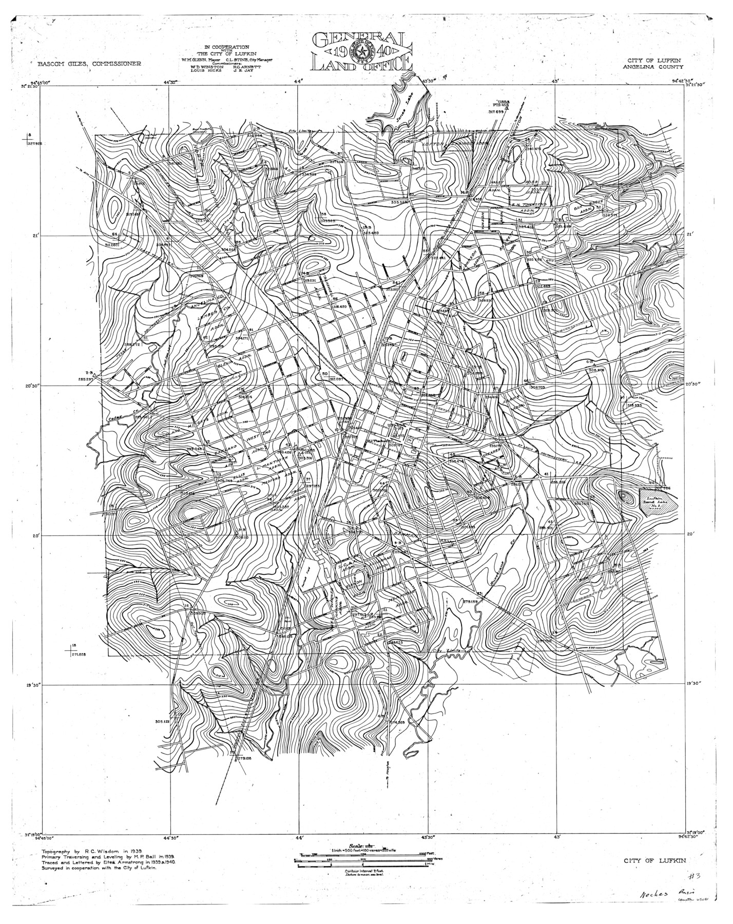
Neches River, City of Lufkin
-
Map/Doc
65081
-
Collection
General Map Collection
-
Object Dates
1940 (Creation Date)
-
People and Organizations
Texas General Land Office (Publisher)
Eltea Armstrong (Draftsman)
Bascom Giles (GLO Commissioner)
Eltea Armstrong (Compiler)
M.P. Ball (Surveyor/Engineer)
R.C. Wisdom (Surveyor/Engineer)
-
Counties
Angelina
-
Subjects
City River Surveys
-
Height x Width
37.5 x 29.7 inches
95.3 x 75.4 cm
Part of: General Map Collection
Shaw Farm, State Prison Farm, Bowie County

Print $20.00
- Digital $50.00
Shaw Farm, State Prison Farm, Bowie County
Size 16.1 x 17.9 inches
Map/Doc 73559
Hardeman County Sketch File 17

Print $2.00
- Digital $50.00
Hardeman County Sketch File 17
Size 7.8 x 6.7 inches
Map/Doc 25025
Palo Pinto County

Print $20.00
- Digital $50.00
Palo Pinto County
1941
Size 44.9 x 35.9 inches
Map/Doc 77389
Flight Mission No. BRE-2P, Frame 103, Nueces County

Print $20.00
- Digital $50.00
Flight Mission No. BRE-2P, Frame 103, Nueces County
1956
Size 18.5 x 22.2 inches
Map/Doc 86788
Denton County Boundary File 4 and 4a and 4b and 4c

Print $2.00
- Digital $50.00
Denton County Boundary File 4 and 4a and 4b and 4c
Size 11.0 x 8.7 inches
Map/Doc 52470
Field Notes of Mercer's Colony, Robertson, Nac[a]gdoches, Fannin, & Lamar Counties.
![1953, Field Notes of Mercer's Colony, Robertson, Nac[a]gdoches, Fannin, & Lamar Counties., General Map Collection](https://historictexasmaps.com/wmedia_w700/pdf_converted_jpg/qi_pdf_thumbnail_897.jpg)
Print $30.00
- Digital $50.00
Field Notes of Mercer's Colony, Robertson, Nac[a]gdoches, Fannin, & Lamar Counties.
1845
Size 9.5 x 14.8 inches
Map/Doc 1953
Controlled Mosaic by Jack Amman Photogrammetric Engineers, Inc - Sheet 40

Print $20.00
- Digital $50.00
Controlled Mosaic by Jack Amman Photogrammetric Engineers, Inc - Sheet 40
1954
Size 20.0 x 24.0 inches
Map/Doc 83495
[Surveys in Austin's Colony along the Colorado River]
![171, [Surveys in Austin's Colony along the Colorado River], General Map Collection](https://historictexasmaps.com/wmedia_w700/maps/171.tif.jpg)
Print $20.00
- Digital $50.00
[Surveys in Austin's Colony along the Colorado River]
1830
Size 30.5 x 12.7 inches
Map/Doc 171
Flight Mission No. CRK-3P, Frame 130, Refugio County

Print $20.00
- Digital $50.00
Flight Mission No. CRK-3P, Frame 130, Refugio County
1956
Size 18.6 x 22.3 inches
Map/Doc 86918
Austin County Boundary File 6

Print $16.00
- Digital $50.00
Austin County Boundary File 6
Size 11.1 x 8.4 inches
Map/Doc 50255
Freestone County Working Sketch 13

Print $40.00
- Digital $50.00
Freestone County Working Sketch 13
1980
Size 42.8 x 59.7 inches
Map/Doc 69255
Harris County State Real Property Sketch 4

Print $20.00
- Digital $50.00
Harris County State Real Property Sketch 4
2004
Size 24.4 x 36.0 inches
Map/Doc 82445
You may also like
Refugio County Boundary File 74

Print $172.00
- Digital $50.00
Refugio County Boundary File 74
Size 9.3 x 4.4 inches
Map/Doc 58272
Current Miscellaneous File 16

Print $20.00
- Digital $50.00
Current Miscellaneous File 16
1951
Size 10.7 x 8.2 inches
Map/Doc 73830
Swisher County Sketch File 1

Print $28.00
- Digital $50.00
Swisher County Sketch File 1
1884
Size 13.0 x 8.2 inches
Map/Doc 37566
Culberson County Sketch File 15

Print $20.00
- Digital $50.00
Culberson County Sketch File 15
1933
Size 30.4 x 24.4 inches
Map/Doc 11267
The Republic County of Bexar. December 31, 1838

Print $20.00
The Republic County of Bexar. December 31, 1838
2020
Size 24.6 x 21.6 inches
Map/Doc 96096
Uvalde County Sketch File 26-1

Print $6.00
- Digital $50.00
Uvalde County Sketch File 26-1
1930
Size 11.5 x 8.9 inches
Map/Doc 39013
Nueces County Sketch File 12c

Print $11.00
- Digital $50.00
Nueces County Sketch File 12c
1889
Size 12.6 x 8.2 inches
Map/Doc 32534
Flight Mission No. CUG-3P, Frame 131, Kleberg County

Print $20.00
- Digital $50.00
Flight Mission No. CUG-3P, Frame 131, Kleberg County
1956
Size 18.7 x 22.4 inches
Map/Doc 86266
Sketch of surveys in Houston Co. on Pine Bayou

Print $2.00
- Digital $50.00
Sketch of surveys in Houston Co. on Pine Bayou
Size 7.7 x 7.6 inches
Map/Doc 69742
Cooke County Working Sketch 30

Print $20.00
- Digital $50.00
Cooke County Working Sketch 30
1979
Size 26.6 x 28.4 inches
Map/Doc 68267
Flight Mission No. DQN-3K, Frame 12, Calhoun County

Print $20.00
- Digital $50.00
Flight Mission No. DQN-3K, Frame 12, Calhoun County
1953
Size 18.8 x 22.4 inches
Map/Doc 84344
Plat Showing Parts of Blocks X, Y, and Z, W.D. and F. W. Johnson Subdivision

Print $20.00
- Digital $50.00
Plat Showing Parts of Blocks X, Y, and Z, W.D. and F. W. Johnson Subdivision
1955
Size 25.7 x 16.5 inches
Map/Doc 92501