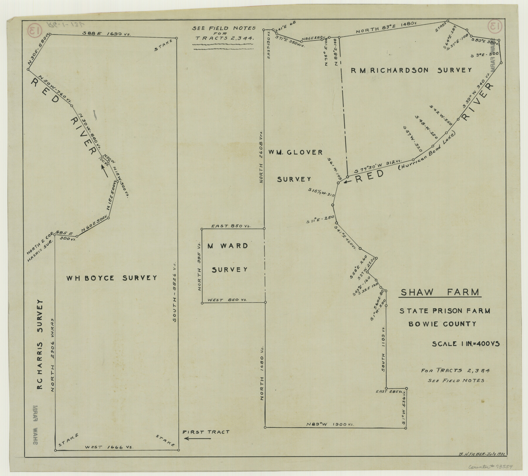
Shaw Farm, State Prison Farm, Bowie County
RG-1-13b
-
Map/Doc
73559
-
Collection
General Map Collection
-
Counties
Bowie
-
Height x Width
16.1 x 17.9 inches
40.9 x 45.5 cm
Part of: General Map Collection
Motley County Sketch File B3 (N)

Print $10.00
- Digital $50.00
Motley County Sketch File B3 (N)
1900
Size 6.5 x 11.9 inches
Map/Doc 31974
Reeves County Sketch File 1a

Print $34.00
- Digital $50.00
Reeves County Sketch File 1a
Size 8.7 x 7.3 inches
Map/Doc 35181
Nueces County Rolled Sketch 96

Print $44.00
Nueces County Rolled Sketch 96
1983
Size 24.2 x 36.5 inches
Map/Doc 7053
Grimes County Working Sketch 12

Print $20.00
- Digital $50.00
Grimes County Working Sketch 12
1982
Size 18.3 x 21.6 inches
Map/Doc 63303
Duval County Working Sketch 50

Print $20.00
- Digital $50.00
Duval County Working Sketch 50
1984
Size 38.0 x 32.0 inches
Map/Doc 68774
Aransas County Rolled Sketch 34

Print $42.00
- Digital $50.00
Aransas County Rolled Sketch 34
2004
Size 24.5 x 36.5 inches
Map/Doc 83637
Flight Mission No. BQR-5K, Frame 71, Brazoria County

Print $20.00
- Digital $50.00
Flight Mission No. BQR-5K, Frame 71, Brazoria County
1952
Size 18.8 x 22.4 inches
Map/Doc 84016
San Augustine County Sketch File 13a

Print $4.00
San Augustine County Sketch File 13a
1879
Size 8.9 x 14.5 inches
Map/Doc 35660
Clay County Working Sketch 4

Print $20.00
- Digital $50.00
Clay County Working Sketch 4
1923
Size 14.7 x 21.9 inches
Map/Doc 68027
Map of Clemens State Farm, Brazoria County, Texas

Print $20.00
- Digital $50.00
Map of Clemens State Farm, Brazoria County, Texas
1934
Size 31.2 x 36.1 inches
Map/Doc 62984
Refugio County Rolled Sketch 4

Print $40.00
- Digital $50.00
Refugio County Rolled Sketch 4
1941
Size 55.7 x 46.4 inches
Map/Doc 9958
Flight Mission No. CUG-2P, Frame 9, Kleberg County

Print $20.00
- Digital $50.00
Flight Mission No. CUG-2P, Frame 9, Kleberg County
1956
Size 18.6 x 22.2 inches
Map/Doc 86181
You may also like
Map of Deaf Smith County, Texas

Print $2.00
- Digital $50.00
Map of Deaf Smith County, Texas
Size 11.6 x 8.9 inches
Map/Doc 90509
Scrivener's North-west Sub-division, Wichita County, Texas

Print $20.00
- Digital $50.00
Scrivener's North-west Sub-division, Wichita County, Texas
Size 20.0 x 26.0 inches
Map/Doc 91994
[Surveys in the Bexar District along the Frio River and Commanche [sic] Creek]
![228, [Surveys in the Bexar District along the Frio River and Commanche [sic] Creek], General Map Collection](https://historictexasmaps.com/wmedia_w700/maps/228.tif.jpg)
Print $20.00
- Digital $50.00
[Surveys in the Bexar District along the Frio River and Commanche [sic] Creek]
1846
Size 23.8 x 18.9 inches
Map/Doc 228
Gillespie County Working Sketch Graphic Index

Print $20.00
- Digital $50.00
Gillespie County Working Sketch Graphic Index
1945
Size 38.0 x 47.4 inches
Map/Doc 76553
Working Sketch Compiled from Original Field Showing Surveys in Irion County Located by J. A. McDonald in 1856 and 1858

Print $20.00
- Digital $50.00
Working Sketch Compiled from Original Field Showing Surveys in Irion County Located by J. A. McDonald in 1856 and 1858
Size 13.1 x 13.8 inches
Map/Doc 92191
Rains County Working Sketch 7

Print $20.00
- Digital $50.00
Rains County Working Sketch 7
1964
Size 32.6 x 38.6 inches
Map/Doc 71833
Kenedy County Rolled Sketch 4

Print $40.00
- Digital $50.00
Kenedy County Rolled Sketch 4
1904
Size 39.4 x 57.6 inches
Map/Doc 10654
Carson County

Print $20.00
- Digital $50.00
Carson County
1932
Size 42.0 x 38.5 inches
Map/Doc 73100
Aransas County Sketch File 38

Print $244.00
- Digital $50.00
Aransas County Sketch File 38
1996
Size 11.1 x 8.7 inches
Map/Doc 13465
Crockett County Rolled Sketch 32

Print $20.00
- Digital $50.00
Crockett County Rolled Sketch 32
1930
Size 44.8 x 34.5 inches
Map/Doc 8697
Jasper County Boundary File 3

Print $54.00
- Digital $50.00
Jasper County Boundary File 3
Size 9.3 x 31.0 inches
Map/Doc 55480
Matagorda County Rolled Sketch 12

Print $20.00
- Digital $50.00
Matagorda County Rolled Sketch 12
Size 30.0 x 28.0 inches
Map/Doc 6681