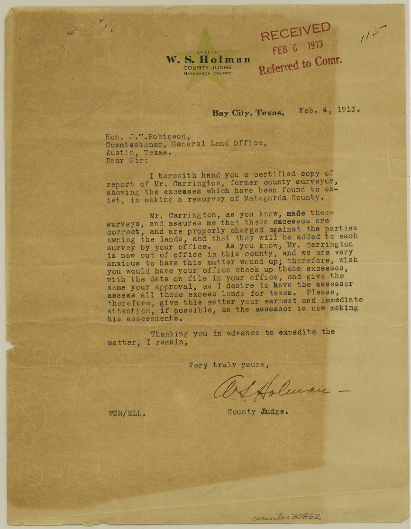
Matagorda County Sketch File 42b
[Surveyors report of list of corrected surveys and excess/short acreage]
-
Map/Doc
30862
-
Collection
General Map Collection
-
Object Dates
2/4/1913 (Creation Date)
11/30/1984 (File Date)
2/4/1913 (Correspondence Date)
11/25/1912 (Correspondence Date)
-
People and Organizations
J.C. Carrington (Surveyor/Engineer)
-
Counties
Matagorda
-
Subjects
Surveying Sketch File
-
Height x Width
11.2 x 8.7 inches
28.4 x 22.1 cm
-
Medium
paper, print
Part of: General Map Collection
Bee County Working Sketch 1

Print $20.00
- Digital $50.00
Bee County Working Sketch 1
Size 23.2 x 40.4 inches
Map/Doc 67251
Runnels County Rolled Sketch 45

Print $20.00
- Digital $50.00
Runnels County Rolled Sketch 45
1954
Size 32.1 x 41.0 inches
Map/Doc 7532


Dallas County Boundary File 1

Print $62.00
- Digital $50.00
Dallas County Boundary File 1
Size 4.1 x 3.7 inches
Map/Doc 52084
Harris County Sketch File 25

Print $8.00
- Digital $50.00
Harris County Sketch File 25
Size 9.0 x 11.8 inches
Map/Doc 25389
Statement of Facts - State of Texas vs. F. B. Olcott, Cause 17090, 12/18/1902

Print $2.00
- Digital $50.00
Statement of Facts - State of Texas vs. F. B. Olcott, Cause 17090, 12/18/1902
1902
Size 14.3 x 8.9 inches
Map/Doc 65724
Goliad County Working Sketch 5

Print $20.00
- Digital $50.00
Goliad County Working Sketch 5
1925
Size 39.9 x 36.5 inches
Map/Doc 63195
Bastrop County Sketch File 14

Print $6.00
- Digital $50.00
Bastrop County Sketch File 14
2018
Size 11.0 x 8.5 inches
Map/Doc 95248
Terrell County Working Sketch 19

Print $20.00
- Digital $50.00
Terrell County Working Sketch 19
1932
Size 18.6 x 25.6 inches
Map/Doc 69801
Young County Rolled Sketch 6

Print $20.00
- Digital $50.00
Young County Rolled Sketch 6
Size 43.4 x 30.8 inches
Map/Doc 8294
Cameron County Rolled Sketch 23

Print $17.00
- Digital $50.00
Cameron County Rolled Sketch 23
Size 10.0 x 15.2 inches
Map/Doc 43931
You may also like
Gray County Boundary File 9

Print $6.00
- Digital $50.00
Gray County Boundary File 9
Size 11.6 x 9.1 inches
Map/Doc 53902
Schleicher County Sketch File 41

Print $6.00
- Digital $50.00
Schleicher County Sketch File 41
1963
Size 16.2 x 9.9 inches
Map/Doc 36544
La Salle County Sketch File 38

Print $40.00
- Digital $50.00
La Salle County Sketch File 38
Size 13.7 x 14.5 inches
Map/Doc 29590
Reagan County Sketch File 21

Print $20.00
- Digital $50.00
Reagan County Sketch File 21
1939
Size 31.1 x 31.3 inches
Map/Doc 10585
Flight Mission No. BRE-1P, Frame 125, Nueces County

Print $20.00
- Digital $50.00
Flight Mission No. BRE-1P, Frame 125, Nueces County
1956
Size 18.6 x 22.7 inches
Map/Doc 86691
Willacy County Sketch File 3

Print $2.00
- Digital $50.00
Willacy County Sketch File 3
Size 8.5 x 11.0 inches
Map/Doc 90000
[Blocks K11, K6, K5, M19, H1, and Leagues North of Block S]
![91409, [Blocks K11, K6, K5, M19, H1, and Leagues North of Block S], Twichell Survey Records](https://historictexasmaps.com/wmedia_w700/maps/91409-1.tif.jpg)
Print $20.00
- Digital $50.00
[Blocks K11, K6, K5, M19, H1, and Leagues North of Block S]
1902
Size 33.3 x 25.3 inches
Map/Doc 91409
Gregg County Boundary File 1

Print $6.00
- Digital $50.00
Gregg County Boundary File 1
Size 10.0 x 7.9 inches
Map/Doc 53981
East Part of Brewster Co.

Print $40.00
- Digital $50.00
East Part of Brewster Co.
1952
Size 48.8 x 31.9 inches
Map/Doc 1785
Dimmit County Working Sketch 55

Print $20.00
- Digital $50.00
Dimmit County Working Sketch 55
1996
Size 33.7 x 34.3 inches
Map/Doc 68716
Galveston, Trinity, and Turtle Bays and Portions of San Jacinto and East Bays in Chambers and Galveston Counties, showing Subdivision for Mineral Development

Print $20.00
- Digital $50.00
Galveston, Trinity, and Turtle Bays and Portions of San Jacinto and East Bays in Chambers and Galveston Counties, showing Subdivision for Mineral Development
1978
Size 46.0 x 43.9 inches
Map/Doc 1905
Duval County Sketch File 7

Print $4.00
- Digital $50.00
Duval County Sketch File 7
1875
Size 10.9 x 8.6 inches
Map/Doc 21294