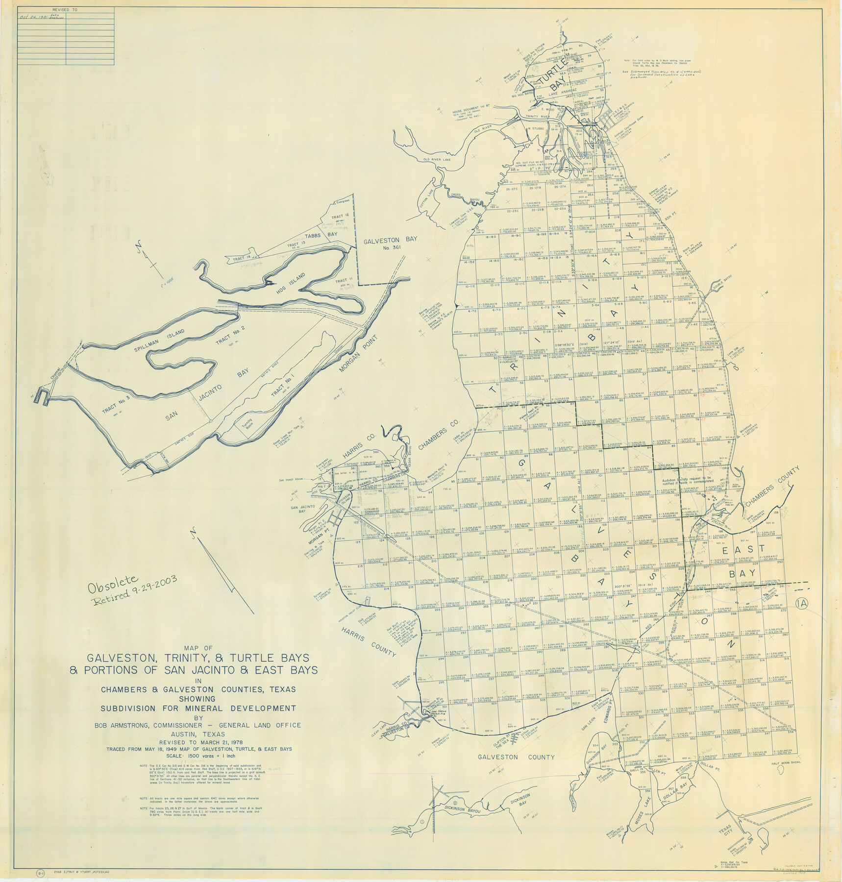
Galveston, Trinity, and Turtle Bays and Portions of San Jacinto and East Bays in Chambers and Galveston Counties, showing Subdivision for Mineral Development
-
Map/Doc
1905
-
Collection
General Map Collection
-
Object Dates
1978 (Creation Date)
-
People and Organizations
General Land Office (Publisher)
-
Counties
Chambers Galveston
-
Subjects
Energy Offshore Submerged Area
-
Height x Width
46.0 x 43.9 inches
116.8 x 111.5 cm
-
Medium
blueline cloth
-
Scale
1500 varas
-
Comments
Gulf coast and submerged state lands. Traced from map of May 18, 1949.
Part of: General Map Collection
Hood County Sketch File 9

Print $26.00
- Digital $50.00
Hood County Sketch File 9
1859
Size 9.6 x 4.5 inches
Map/Doc 26586
Henderson County

Print $40.00
- Digital $50.00
Henderson County
1988
Size 30.8 x 63.0 inches
Map/Doc 77310
A Map of the Republic of Texas and the adjacent territories, indicating the grants of land conceded under the empresario system of Mexico

Print $20.00
- Digital $50.00
A Map of the Republic of Texas and the adjacent territories, indicating the grants of land conceded under the empresario system of Mexico
1841
Size 13.8 x 16.6 inches
Map/Doc 93752
Flight Mission No. CUG-2P, Frame 77, Kleberg County

Print $20.00
- Digital $50.00
Flight Mission No. CUG-2P, Frame 77, Kleberg County
1956
Size 18.6 x 22.3 inches
Map/Doc 86209
Brazoria County Working Sketch 44

Print $20.00
- Digital $50.00
Brazoria County Working Sketch 44
1988
Size 26.6 x 24.9 inches
Map/Doc 67529
DeWitt County Working Sketch 7

Print $20.00
- Digital $50.00
DeWitt County Working Sketch 7
1977
Size 19.0 x 21.2 inches
Map/Doc 68597
San Augustine County Sketch File 16

Print $8.00
San Augustine County Sketch File 16
1946
Size 11.3 x 8.6 inches
Map/Doc 35664
Panola County Working Sketch 40

Print $20.00
- Digital $50.00
Panola County Working Sketch 40
1995
Map/Doc 71449
Runnels County Sketch File 4

Print $6.00
Runnels County Sketch File 4
1871
Size 12.9 x 8.1 inches
Map/Doc 35434
Schleicher County Sketch File 22

Print $9.00
- Digital $50.00
Schleicher County Sketch File 22
1927
Size 12.8 x 11.7 inches
Map/Doc 36512
Coke County Working Sketch 1

Print $20.00
- Digital $50.00
Coke County Working Sketch 1
Size 16.3 x 36.2 inches
Map/Doc 68038
Liberty County Sketch File 60

Print $12.00
- Digital $50.00
Liberty County Sketch File 60
1943
Size 14.2 x 8.6 inches
Map/Doc 30071
You may also like
Young County Sketch File 4

Print $6.00
- Digital $50.00
Young County Sketch File 4
1852
Size 5.3 x 4.3 inches
Map/Doc 40849
Harris County Rolled Sketch 88

Print $20.00
- Digital $50.00
Harris County Rolled Sketch 88
1937
Size 34.9 x 22.7 inches
Map/Doc 6126
Mitchell County Rolled Sketch 4

Print $20.00
- Digital $50.00
Mitchell County Rolled Sketch 4
Size 32.6 x 41.4 inches
Map/Doc 6785
Edwards County Working Sketch 95

Print $20.00
- Digital $50.00
Edwards County Working Sketch 95
1968
Size 26.0 x 24.9 inches
Map/Doc 68971
The south west and N.E. lines of Mary Thomas and A. Morrallis surveys

Print $2.00
- Digital $50.00
The south west and N.E. lines of Mary Thomas and A. Morrallis surveys
1847
Size 9.4 x 8.1 inches
Map/Doc 336
Galveston County Sketch File 47

Print $14.00
- Digital $50.00
Galveston County Sketch File 47
1976
Size 11.3 x 8.9 inches
Map/Doc 23454
Culberson County Rolled Sketch 54

Print $40.00
- Digital $50.00
Culberson County Rolled Sketch 54
1968
Size 59.0 x 29.4 inches
Map/Doc 10300
Kleberg County Rolled Sketch 10-6

Print $20.00
- Digital $50.00
Kleberg County Rolled Sketch 10-6
1951
Size 38.0 x 39.1 inches
Map/Doc 9399
[J. Poitevent Block 2, T. T. RR. Block 2, C. C. Slaughter Block 1]
![90619, [J. Poitevent Block 2, T. T. RR. Block 2, C. C. Slaughter Block 1], Twichell Survey Records](https://historictexasmaps.com/wmedia_w700/maps/90619-1.tif.jpg)
Print $2.00
- Digital $50.00
[J. Poitevent Block 2, T. T. RR. Block 2, C. C. Slaughter Block 1]
Size 9.1 x 11.7 inches
Map/Doc 90619
Wise County Sketch File F

Print $20.00
- Digital $50.00
Wise County Sketch File F
1857
Size 16.2 x 29.2 inches
Map/Doc 12704
Wilbarger County Sketch File 4

Print $4.00
- Digital $50.00
Wilbarger County Sketch File 4
1883
Size 12.7 x 8.2 inches
Map/Doc 40168
Val Verde County Working Sketch 82

Print $20.00
- Digital $50.00
Val Verde County Working Sketch 82
1973
Size 42.1 x 33.1 inches
Map/Doc 72217