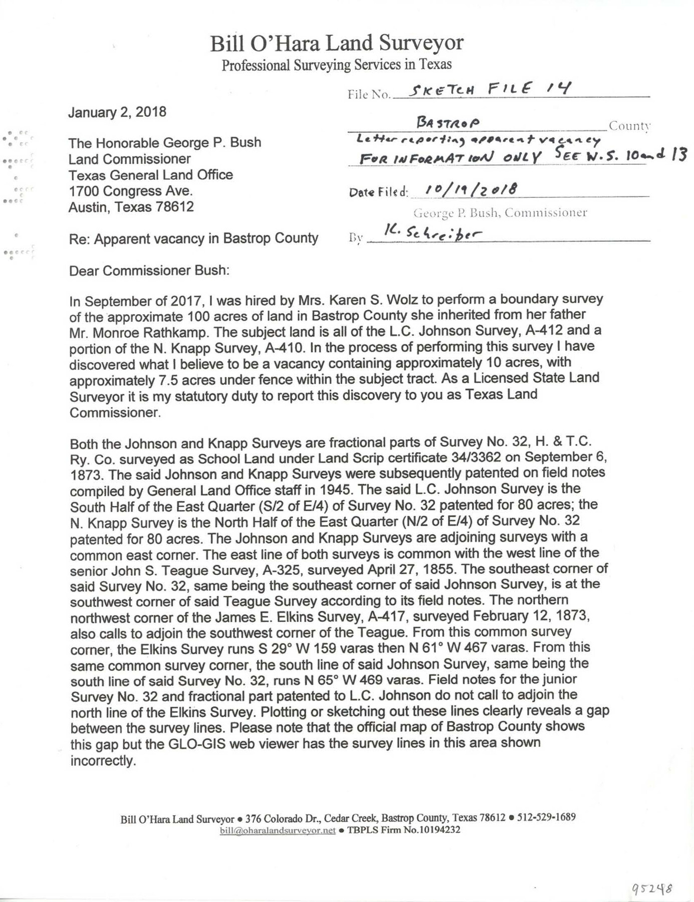
Bastrop County Sketch File 14
Letter reporting apparent vacancy
-
Map/Doc
95248
-
Collection
General Map Collection
-
Object Dates
1/2/2018 (Creation Date)
10/19/2018 (File Date)
-
People and Organizations
Bill O'Hara (Surveyor/Engineer)
-
Counties
Bastrop
-
Subjects
Surveying Sketch File
-
Height x Width
11.0 x 8.5 inches
27.9 x 21.6 cm
-
Medium
multi-page, multi-format
-
Comments
Filed for information only. See Bastrop County Working Sketch 10 (67310) and Bastrop County Working Sketch 13 (67313)
Related maps
Bastrop County Working Sketch 10

Print $20.00
- Digital $50.00
Bastrop County Working Sketch 10
1968
Size 31.9 x 37.7 inches
Map/Doc 67310
Bastrop County Working Sketch 13

Print $20.00
- Digital $50.00
Bastrop County Working Sketch 13
1979
Size 23.6 x 30.0 inches
Map/Doc 67313
Part of: General Map Collection
[Surveys along the Trinity River and below]
![101, [Surveys along the Trinity River and below], General Map Collection](https://historictexasmaps.com/wmedia_w700/maps/101.tif.jpg)
Print $20.00
- Digital $50.00
[Surveys along the Trinity River and below]
1840
Size 22.6 x 17.6 inches
Map/Doc 101
Zavala County Sketch File 10

Print $20.00
- Digital $50.00
Zavala County Sketch File 10
Size 17.6 x 25.7 inches
Map/Doc 12728
Jones County Sketch File 6

Print $2.00
- Digital $50.00
Jones County Sketch File 6
1873
Size 8.3 x 11.8 inches
Map/Doc 28494
Val Verde County Working Sketch Graphic Index, Sheet 2 (Sketches 26 to 88)

Print $20.00
- Digital $50.00
Val Verde County Working Sketch Graphic Index, Sheet 2 (Sketches 26 to 88)
1944
Size 40.3 x 36.4 inches
Map/Doc 76725
Flight Mission No. BRE-4P, Frame 166, Nueces County

Print $20.00
- Digital $50.00
Flight Mission No. BRE-4P, Frame 166, Nueces County
1956
Size 18.5 x 22.4 inches
Map/Doc 86829
Kimble County Working Sketch 35

Print $20.00
- Digital $50.00
Kimble County Working Sketch 35
1946
Size 24.7 x 32.0 inches
Map/Doc 70103
Uvalde County Rolled Sketch 14

Print $20.00
- Digital $50.00
Uvalde County Rolled Sketch 14
1977
Size 22.0 x 25.9 inches
Map/Doc 8098
Jasper County Working Sketch 25

Print $20.00
- Digital $50.00
Jasper County Working Sketch 25
1951
Size 21.6 x 32.3 inches
Map/Doc 66487
Falls County Sketch File 10

Print $14.00
- Digital $50.00
Falls County Sketch File 10
Size 12.9 x 8.4 inches
Map/Doc 22345
Callahan County Sketch File 16

Print $4.00
- Digital $50.00
Callahan County Sketch File 16
Size 14.6 x 8.7 inches
Map/Doc 35895
[Affadavit regarding boundary lines between the several coastal counties from coastline to Continental Shelf]
![2089, [Affadavit regarding boundary lines between the several coastal counties from coastline to Continental Shelf], General Map Collection](https://historictexasmaps.com/wmedia_w700/maps/2089-1.tif.jpg)
Print $20.00
- Digital $50.00
[Affadavit regarding boundary lines between the several coastal counties from coastline to Continental Shelf]
1947
Size 18.1 x 12.7 inches
Map/Doc 2089
Childress County Sketch File 3

Print $30.00
- Digital $50.00
Childress County Sketch File 3
1885
Size 14.1 x 8.6 inches
Map/Doc 18245
You may also like
[Sketch showing G. & M. Block 5]
![91704, [Sketch showing G. & M. Block 5], Twichell Survey Records](https://historictexasmaps.com/wmedia_w700/maps/91704-1.tif.jpg)
Print $2.00
- Digital $50.00
[Sketch showing G. & M. Block 5]
Size 7.5 x 5.8 inches
Map/Doc 91704
Pecos County Working Sketch 135

Print $20.00
- Digital $50.00
Pecos County Working Sketch 135
1979
Size 46.4 x 37.3 inches
Map/Doc 71609
La Salle County Working Sketch 53

Print $20.00
- Digital $50.00
La Salle County Working Sketch 53
Size 14.3 x 15.9 inches
Map/Doc 67362
Ector County Working Sketch 8

Print $20.00
- Digital $50.00
Ector County Working Sketch 8
1944
Size 40.5 x 26.5 inches
Map/Doc 68851
Brazoria County Sketch File 11

Print $4.00
- Digital $50.00
Brazoria County Sketch File 11
Size 10.5 x 8.5 inches
Map/Doc 14965
[Section 70, Block 8, Dawson and Lynn Counties, Texas]
![92562, [Section 70, Block 8, Dawson and Lynn Counties, Texas], Twichell Survey Records](https://historictexasmaps.com/wmedia_w700/maps/92562-1.tif.jpg)
Print $20.00
- Digital $50.00
[Section 70, Block 8, Dawson and Lynn Counties, Texas]
Size 23.9 x 19.6 inches
Map/Doc 92562
Map showing Alamo-Donna Farms, Irrigated Section in Hidalgo County, Texas

Print $20.00
- Digital $50.00
Map showing Alamo-Donna Farms, Irrigated Section in Hidalgo County, Texas
1920
Size 27.5 x 13.3 inches
Map/Doc 95803
Garza County Rolled Sketch 13

Print $26.00
- Digital $50.00
Garza County Rolled Sketch 13
1935
Size 45.5 x 36.7 inches
Map/Doc 9047
Partial View of Austin, Texas

Print $20.00
Partial View of Austin, Texas
1895
Size 28.4 x 41.8 inches
Map/Doc 76205
Karte des Staates, Texas

Print $20.00
- Digital $50.00
Karte des Staates, Texas
1851
Size 25.5 x 30.8 inches
Map/Doc 2123
Kinney County Working Sketch 56

Print $40.00
- Digital $50.00
Kinney County Working Sketch 56
1987
Size 40.5 x 62.8 inches
Map/Doc 70238
La Salle County Sketch File 34

Print $6.00
- Digital $50.00
La Salle County Sketch File 34
Size 15.8 x 9.5 inches
Map/Doc 29585