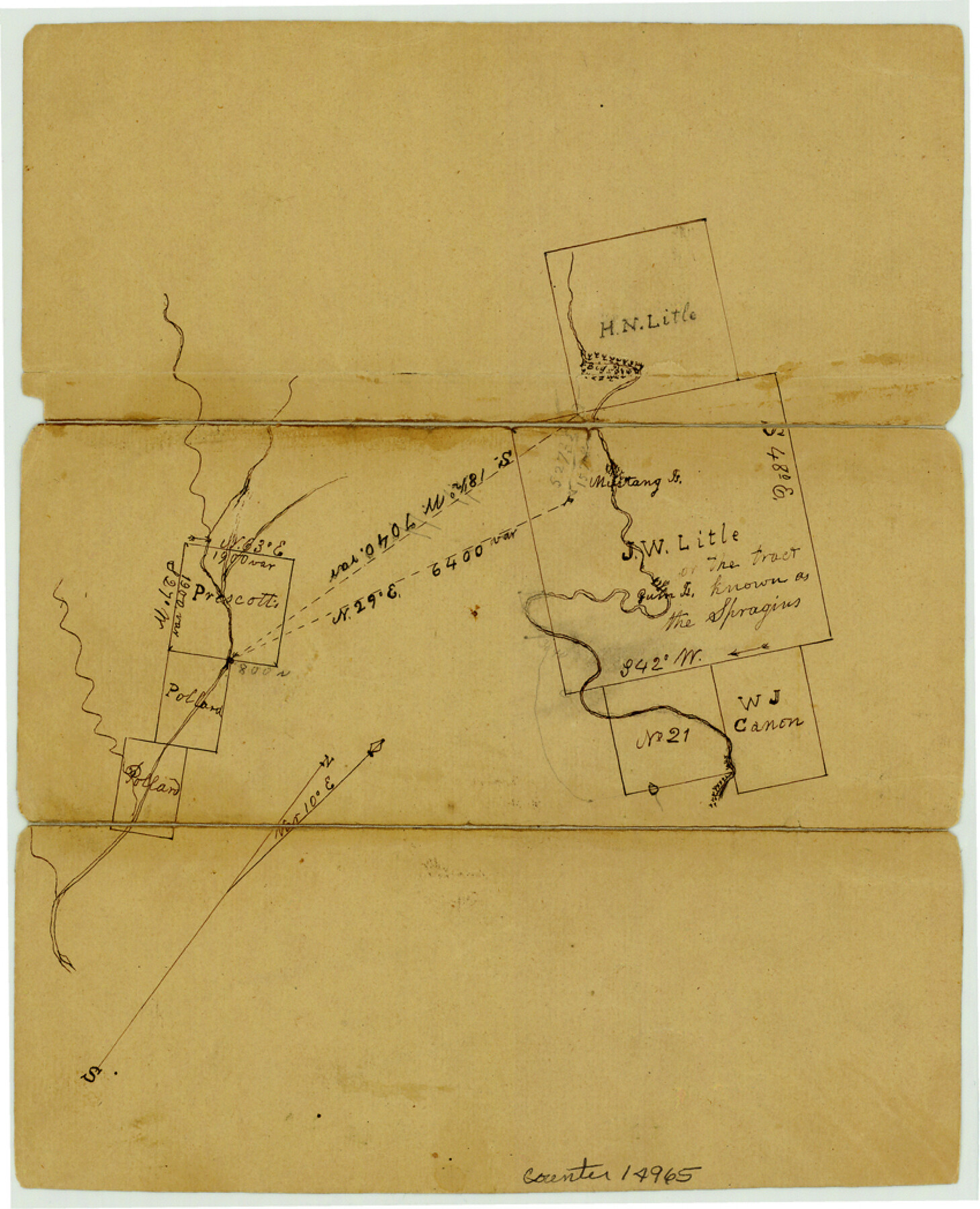
Brazoria County Sketch File 11
[Sketch of connections from Chocolate Bayou to the Thomas Spragins survey and Mustang Bayou]
-
Map/Doc
14965
-
Collection
General Map Collection
-
Object Dates
1876/2/23 (File Date)
-
Counties
Brazoria
-
Subjects
Surveying Sketch File
-
Height x Width
10.5 x 8.5 inches
26.7 x 21.6 cm
-
Medium
paper, manuscript
-
Features
Big Spring
Mustang Island
Part of: General Map Collection
Fort Bend County Sketch File 34

Print $20.00
- Digital $50.00
Fort Bend County Sketch File 34
Size 22.3 x 18.0 inches
Map/Doc 11514
Hardeman County Boundary File 3

Print $18.00
- Digital $50.00
Hardeman County Boundary File 3
Size 14.1 x 8.8 inches
Map/Doc 54375
Flight Mission No. BQR-13K, Frame 24, Brazoria County

Print $20.00
- Digital $50.00
Flight Mission No. BQR-13K, Frame 24, Brazoria County
1952
Size 18.9 x 22.4 inches
Map/Doc 84072
Midland County Boundary File 4b

Print $18.00
- Digital $50.00
Midland County Boundary File 4b
Size 13.6 x 9.0 inches
Map/Doc 57186
Polk County Working Sketch 2

Print $20.00
- Digital $50.00
Polk County Working Sketch 2
1909
Size 27.7 x 20.1 inches
Map/Doc 71617
Mitchell County

Print $20.00
- Digital $50.00
Mitchell County
1971
Size 39.9 x 33.3 inches
Map/Doc 77375
Foard County Sketch File 16

Print $6.00
- Digital $50.00
Foard County Sketch File 16
1885
Size 14.2 x 8.7 inches
Map/Doc 22825
Flight Mission No. CUG-2P, Frame 10, Kleberg County

Print $20.00
- Digital $50.00
Flight Mission No. CUG-2P, Frame 10, Kleberg County
1956
Size 18.7 x 22.3 inches
Map/Doc 86182
Guadalupe County Sketch File 12

Print $8.00
- Digital $50.00
Guadalupe County Sketch File 12
1869
Size 12.9 x 8.2 inches
Map/Doc 24683
Rockwall County Sketch File 8

Print $4.00
Rockwall County Sketch File 8
Size 7.1 x 10.6 inches
Map/Doc 35429
Maps of Gulf Intracoastal Waterway, Texas - Sabine River to the Rio Grande and connecting waterways including ship channels

Print $20.00
- Digital $50.00
Maps of Gulf Intracoastal Waterway, Texas - Sabine River to the Rio Grande and connecting waterways including ship channels
1966
Size 14.5 x 22.4 inches
Map/Doc 61918
Dickens County

Print $20.00
- Digital $50.00
Dickens County
1880
Size 20.8 x 19.1 inches
Map/Doc 3485
You may also like
Flight Mission No. DQN-2K, Frame 115, Calhoun County

Print $20.00
- Digital $50.00
Flight Mission No. DQN-2K, Frame 115, Calhoun County
1953
Size 18.6 x 22.3 inches
Map/Doc 84291
Borden County Sketch File 3a

Print $4.00
- Digital $50.00
Borden County Sketch File 3a
1902
Size 12.5 x 8.6 inches
Map/Doc 14705
Sketch Showing Lands Southeast of Creek Outside of H. C. Sisco's Area, Exhibit H

Print $20.00
- Digital $50.00
Sketch Showing Lands Southeast of Creek Outside of H. C. Sisco's Area, Exhibit H
Size 20.0 x 24.5 inches
Map/Doc 91373
[Texas Gulf Coast from Rio Grande to Sabine Lake]
![72686, [Texas Gulf Coast from Rio Grande to Sabine Lake], General Map Collection](https://historictexasmaps.com/wmedia_w700/maps/72686.tif.jpg)
Print $20.00
- Digital $50.00
[Texas Gulf Coast from Rio Grande to Sabine Lake]
Size 28.0 x 18.3 inches
Map/Doc 72686
Flight Mission No. BQR-22K, Frame 47, Brazoria County

Print $20.00
- Digital $50.00
Flight Mission No. BQR-22K, Frame 47, Brazoria County
1953
Size 18.8 x 22.4 inches
Map/Doc 84131
[Location, Chicago & Rock Island Railroad Through Tarrant County]
![64343, [Location, Chicago & Rock Island Railroad Through Tarrant County], General Map Collection](https://historictexasmaps.com/wmedia_w700/maps/64343.tif.jpg)
Print $40.00
- Digital $50.00
[Location, Chicago & Rock Island Railroad Through Tarrant County]
Size 25.9 x 115.5 inches
Map/Doc 64343
Kinney County Working Sketch 13

Print $20.00
- Digital $50.00
Kinney County Working Sketch 13
1941
Size 20.3 x 23.9 inches
Map/Doc 70195
Upton County Working Sketch 25

Print $20.00
- Digital $50.00
Upton County Working Sketch 25
1953
Size 38.2 x 31.2 inches
Map/Doc 69521
Donley County Sketch File 28

Print $40.00
- Digital $50.00
Donley County Sketch File 28
Size 25.7 x 9.1 inches
Map/Doc 21266
Map of Upshur County Texas

Print $20.00
- Digital $50.00
Map of Upshur County Texas
1873
Size 20.4 x 15.2 inches
Map/Doc 4635
Culberson County Working Sketch 14

Print $20.00
- Digital $50.00
Culberson County Working Sketch 14
1923
Size 17.9 x 19.2 inches
Map/Doc 68466
Sketch of surveys in Houston Co. on Pine Bayou

Print $2.00
- Digital $50.00
Sketch of surveys in Houston Co. on Pine Bayou
Size 7.7 x 7.6 inches
Map/Doc 69742