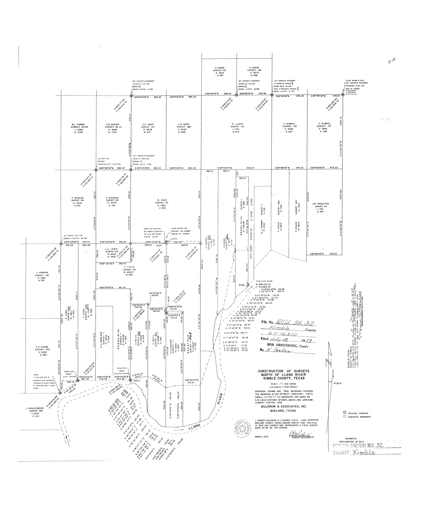
Kimble County Rolled Sketch 32
Construction of surveys north of Llano River, Kimble County, Texas
-
Map/Doc
6522
-
Collection
General Map Collection
-
Object Dates
1973 (Creation Date)
1973/7/18 (File Date)
-
People and Organizations
Robert Muldrow IV (Surveyor/Engineer)
-
Counties
Kimble
-
Subjects
Surveying Rolled Sketch
-
Height x Width
23.1 x 19.6 inches
58.7 x 49.8 cm
-
Scale
1" = 300 varas
Part of: General Map Collection
Flight Mission No. CLL-1N, Frame 38, Willacy County

Print $20.00
- Digital $50.00
Flight Mission No. CLL-1N, Frame 38, Willacy County
1954
Size 18.4 x 22.1 inches
Map/Doc 87019
Gregg County Rolled Sketch 25

Print $40.00
- Digital $50.00
Gregg County Rolled Sketch 25
1933
Size 27.3 x 51.7 inches
Map/Doc 9076
Brazoria County Working Sketch 21

Print $20.00
- Digital $50.00
Brazoria County Working Sketch 21
1954
Size 41.5 x 41.8 inches
Map/Doc 67506
Railroad Track Map, H&TCRRCo., Falls County, Texas

Print $4.00
- Digital $50.00
Railroad Track Map, H&TCRRCo., Falls County, Texas
1918
Size 11.6 x 18.3 inches
Map/Doc 62855
Bosque County Boundary File 1

Print $34.00
- Digital $50.00
Bosque County Boundary File 1
Size 10.7 x 8.2 inches
Map/Doc 50672
Map of Brassos [sic] & Bosque Surveys
![146, Map of Brassos [sic] & Bosque Surveys, General Map Collection](https://historictexasmaps.com/wmedia_w700/maps/146.tif.jpg)
Print $20.00
- Digital $50.00
Map of Brassos [sic] & Bosque Surveys
1841
Size 27.7 x 18.9 inches
Map/Doc 146
Intracoastal Waterway - Galveston Bay to West Bay including Galveston Bay Entrance

Print $20.00
- Digital $50.00
Intracoastal Waterway - Galveston Bay to West Bay including Galveston Bay Entrance
1957
Size 27.2 x 38.6 inches
Map/Doc 69933
Garza County Working Sketch 1

Print $20.00
- Digital $50.00
Garza County Working Sketch 1
1902
Size 39.3 x 25.6 inches
Map/Doc 63148
Archer County

Print $20.00
- Digital $50.00
Archer County
1926
Size 43.7 x 37.9 inches
Map/Doc 95419
Wichita County Sketch File A

Print $4.00
- Digital $50.00
Wichita County Sketch File A
1861
Size 7.8 x 10.3 inches
Map/Doc 40036
Map Showing Resurvey of Capitol Leagues, Deaf Smith Co.

Print $20.00
- Digital $50.00
Map Showing Resurvey of Capitol Leagues, Deaf Smith Co.
1918
Size 42.5 x 31.9 inches
Map/Doc 1756
Panola County Working Sketch 5

Print $20.00
- Digital $50.00
Panola County Working Sketch 5
1940
Map/Doc 71414
You may also like
Duval County Working Sketch 11

Print $20.00
- Digital $50.00
Duval County Working Sketch 11
1937
Size 24.3 x 19.4 inches
Map/Doc 68724
Anderson County Sketch File 2

Print $4.00
- Digital $50.00
Anderson County Sketch File 2
1847
Size 12.6 x 8.2 inches
Map/Doc 12739
Hoffman & Walker's Pictorial, Historical Map of Texas

Hoffman & Walker's Pictorial, Historical Map of Texas
1960
Size 44.0 x 45.5 inches
Map/Doc 2122
The Republic County of Harrison. December 29, 1845

Print $20.00
The Republic County of Harrison. December 29, 1845
2020
Size 18.6 x 21.7 inches
Map/Doc 96177
Cherokee County Sketch File 2

Print $6.00
- Digital $50.00
Cherokee County Sketch File 2
1857
Size 8.2 x 7.9 inches
Map/Doc 18112
Amistad International Reservoir on Rio Grande 86

Print $20.00
- Digital $50.00
Amistad International Reservoir on Rio Grande 86
1949
Size 28.3 x 40.1 inches
Map/Doc 75515
Gonzales County Working Sketch 9

Print $20.00
- Digital $50.00
Gonzales County Working Sketch 9
1981
Size 18.8 x 18.2 inches
Map/Doc 63225
Runnels County Rolled Sketch 31

Print $20.00
- Digital $50.00
Runnels County Rolled Sketch 31
Size 32.4 x 24.1 inches
Map/Doc 7519
Outer Continental Shelf Leasing Maps (Louisiana Offshore Operations)

Print $20.00
- Digital $50.00
Outer Continental Shelf Leasing Maps (Louisiana Offshore Operations)
1959
Size 18.0 x 14.0 inches
Map/Doc 76118
Flight Mission No. BRE-2P, Frame 26, Nueces County

Print $20.00
- Digital $50.00
Flight Mission No. BRE-2P, Frame 26, Nueces County
1956
Size 18.6 x 22.7 inches
Map/Doc 86735
Sherman County

Print $20.00
- Digital $50.00
Sherman County
1932
Size 39.6 x 36.4 inches
Map/Doc 77422
La Salle County Working Sketch 32

Print $20.00
- Digital $50.00
La Salle County Working Sketch 32
1955
Size 35.8 x 27.1 inches
Map/Doc 70333