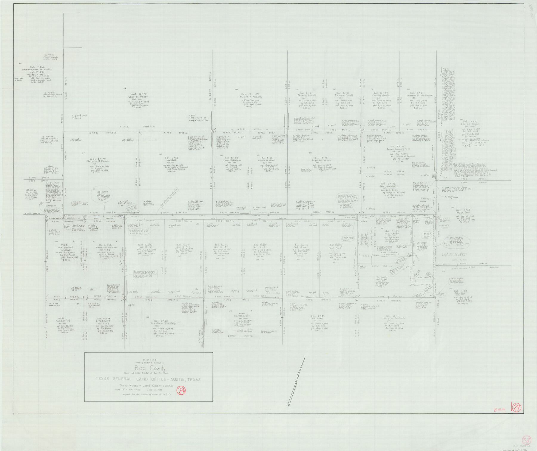
Bee County Working Sketch 29a
-
Map/Doc
67279
-
Collection
General Map Collection
-
Object Dates
6/2/1988 (Creation Date)
-
People and Organizations
Bill O'Hara (Draftsman)
Garry Mauro (GLO Commissioner)
-
Counties
Bee
-
Subjects
Surveying Working Sketch
-
Height x Width
36.3 x 43.1 inches
92.2 x 109.5 cm
-
Scale
1" = 300 varas
-
Comments
Sheet 1 of 2
Surveys located about 16 1/2 miles North 30 degrees West of Beeville, Texas.
Related maps
Bee County Working Sketch 29b

Print $20.00
- Digital $50.00
Bee County Working Sketch 29b
1988
Size 34.4 x 36.3 inches
Map/Doc 67280
Part of: General Map Collection
Val Verde County Sketch File XXX4

Print $4.00
- Digital $50.00
Val Verde County Sketch File XXX4
Size 12.8 x 8.4 inches
Map/Doc 39098
Yoakum County Working Sketch 1

Print $20.00
- Digital $50.00
Yoakum County Working Sketch 1
1949
Size 18.5 x 19.1 inches
Map/Doc 62023
Coke County Sketch File 4

Print $46.00
- Digital $50.00
Coke County Sketch File 4
1884
Size 9.2 x 7.7 inches
Map/Doc 18566
Reagan County Rolled Sketch 19

Print $20.00
- Digital $50.00
Reagan County Rolled Sketch 19
1939
Size 24.0 x 20.5 inches
Map/Doc 7445
Preliminary survey of the entrance to the Rio Grande, Texas

Print $20.00
- Digital $50.00
Preliminary survey of the entrance to the Rio Grande, Texas
1854
Size 18.3 x 24.5 inches
Map/Doc 73005
Culberson County Sketch File 18

Print $8.00
- Digital $50.00
Culberson County Sketch File 18
Size 14.3 x 8.8 inches
Map/Doc 20185
Grimes County Working Sketch 18

Print $20.00
- Digital $50.00
Grimes County Working Sketch 18
1990
Size 33.1 x 42.5 inches
Map/Doc 63309
Concho County Rolled Sketch 4

Print $20.00
- Digital $50.00
Concho County Rolled Sketch 4
1948
Size 47.3 x 43.6 inches
Map/Doc 8649

Ferguson State Farm

Print $20.00
- Digital $50.00
Ferguson State Farm
Size 19.2 x 20.4 inches
Map/Doc 62990
Victoria County

Print $20.00
- Digital $50.00
Victoria County
1858
Size 26.5 x 29.2 inches
Map/Doc 4115
Erath County Working Sketch 42

Print $20.00
- Digital $50.00
Erath County Working Sketch 42
1981
Size 23.0 x 23.6 inches
Map/Doc 69123
You may also like
Map showing the environs of Brazos Island, Texas

Print $20.00
- Digital $50.00
Map showing the environs of Brazos Island, Texas
Size 18.2 x 25.0 inches
Map/Doc 72925
Map and Field Notes of D. & N. T. RR. Through E. L. Ellwood's Pasture

Print $20.00
- Digital $50.00
Map and Field Notes of D. & N. T. RR. Through E. L. Ellwood's Pasture
1912
Size 39.5 x 12.1 inches
Map/Doc 91003
Map of the United States

Print $20.00
- Digital $50.00
Map of the United States
1851
Size 24.7 x 26.0 inches
Map/Doc 96632
Flight Mission No. DAG-21K, Frame 123, Matagorda County

Print $20.00
- Digital $50.00
Flight Mission No. DAG-21K, Frame 123, Matagorda County
1952
Size 18.5 x 22.4 inches
Map/Doc 86449
Orange County Working Sketch 21

Print $20.00
- Digital $50.00
Orange County Working Sketch 21
1933
Size 27.0 x 28.1 inches
Map/Doc 71353
Waller County Sketch File 7

Print $4.00
- Digital $50.00
Waller County Sketch File 7
1873
Size 9.4 x 8.2 inches
Map/Doc 39608

Calhoun County Rolled Sketch 28B

Print $7.00
- Digital $50.00
Calhoun County Rolled Sketch 28B
1834
Size 10.5 x 15.4 inches
Map/Doc 43684
Live Oak County Working Sketch 2

Print $20.00
- Digital $50.00
Live Oak County Working Sketch 2
1891
Size 17.9 x 18.2 inches
Map/Doc 70587
The Republic County of Colorado. 1841

Print $20.00
The Republic County of Colorado. 1841
2020
Size 18.4 x 21.7 inches
Map/Doc 96123
Harris County Working Sketch 53

Print $20.00
- Digital $50.00
Harris County Working Sketch 53
1948
Size 28.0 x 26.9 inches
Map/Doc 65945
Trinity County Sketch File 43

Print $40.00
- Digital $50.00
Trinity County Sketch File 43
1854
Size 19.2 x 23.6 inches
Map/Doc 12495