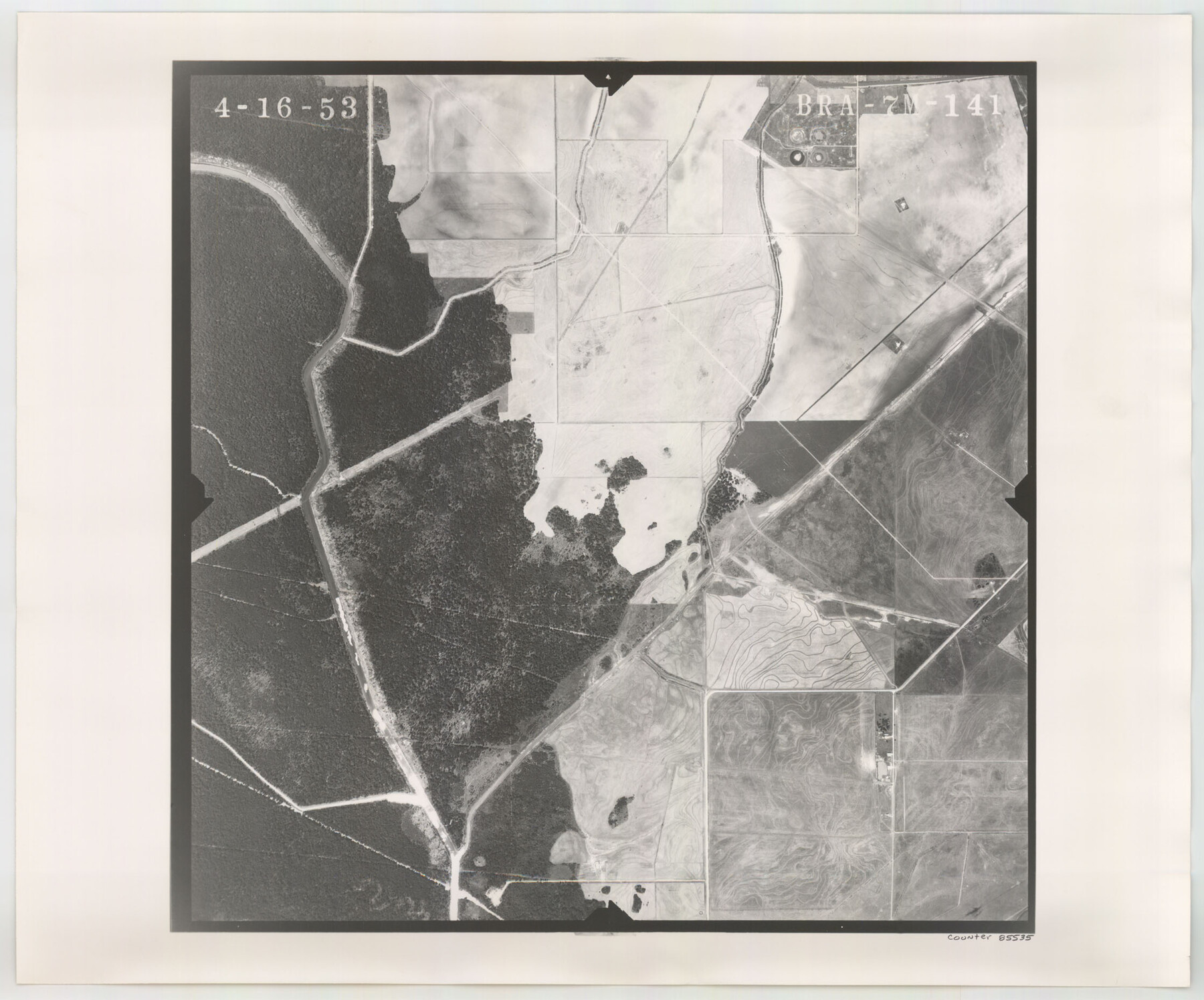
Flight Mission No. BRA-7M, Frame 141, Jefferson County
BRA-7M-141
-
Map/Doc
85535
-
Collection
General Map Collection
-
Object Dates
1953/4/16 (Creation Date)
-
People and Organizations
U. S. Department of Agriculture (Publisher)
-
Counties
Jefferson
-
Subjects
Aerial Photograph
-
Height x Width
18.6 x 22.4 inches
47.2 x 56.9 cm
-
Comments
Flown by Jack Ammann Photogrammetric Engineers of San Antonio, Texas.
Part of: General Map Collection

Stephens County Working Sketch 41

Print $40.00
- Digital $50.00
Stephens County Working Sketch 41
2008
Size 34.1 x 48.0 inches
Map/Doc 88737
Haskell County Rolled Sketch 12
Print $40.00
- Digital $50.00
Haskell County Rolled Sketch 12
Size 56.7 x 36.1 inches
Map/Doc 9147
Hall County Sketch File 31

Print $8.00
- Digital $50.00
Hall County Sketch File 31
1951
Size 14.3 x 8.9 inches
Map/Doc 24835
Palo Pinto County Boundary File 3

Print $58.00
- Digital $50.00
Palo Pinto County Boundary File 3
Size 14.3 x 8.7 inches
Map/Doc 57800
Flight Mission No. BQR-22K, Frame 41, Brazoria County

Print $20.00
- Digital $50.00
Flight Mission No. BQR-22K, Frame 41, Brazoria County
1953
Size 18.8 x 22.5 inches
Map/Doc 84125
Johnson County Working Sketch 17

Print $40.00
- Digital $50.00
Johnson County Working Sketch 17
1985
Size 48.3 x 44.4 inches
Map/Doc 66630
Flight Mission No. CUG-3P, Frame 16, Kleberg County

Print $20.00
- Digital $50.00
Flight Mission No. CUG-3P, Frame 16, Kleberg County
1956
Size 18.3 x 22.2 inches
Map/Doc 86226
Kerr County Rolled Sketch 4

Print $20.00
- Digital $50.00
Kerr County Rolled Sketch 4
Size 21.8 x 23.1 inches
Map/Doc 6493
Flight Mission No. DQN-2K, Frame 118, Calhoun County

Print $20.00
- Digital $50.00
Flight Mission No. DQN-2K, Frame 118, Calhoun County
1953
Size 18.5 x 22.2 inches
Map/Doc 84294
Fannin County Sketch File 11

Print $6.00
- Digital $50.00
Fannin County Sketch File 11
1860
Size 9.9 x 7.4 inches
Map/Doc 22457
Duval County Working Sketch 22

Print $20.00
- Digital $50.00
Duval County Working Sketch 22
1942
Size 21.9 x 26.0 inches
Map/Doc 68746
You may also like

Coleman County Sketch File 45a

Print $4.00
- Digital $50.00
Coleman County Sketch File 45a
1897
Size 9.8 x 6.2 inches
Map/Doc 18791
Panola County Working Sketch 8

Print $20.00
- Digital $50.00
Panola County Working Sketch 8
1943
Map/Doc 71417
Outer Continental Shelf Leasing Maps (Louisiana Offshore Operations)

Print $20.00
- Digital $50.00
Outer Continental Shelf Leasing Maps (Louisiana Offshore Operations)
1954
Size 21.2 x 16.3 inches
Map/Doc 76103
Flight Mission No. BQR-5K, Frame 69, Brazoria County

Print $20.00
- Digital $50.00
Flight Mission No. BQR-5K, Frame 69, Brazoria County
1952
Size 18.8 x 22.4 inches
Map/Doc 84014
Working Sketch from Crosby and Garza Cos.

Print $20.00
- Digital $50.00
Working Sketch from Crosby and Garza Cos.
1902
Size 28.7 x 38.7 inches
Map/Doc 90794
Gonzales County

Print $20.00
- Digital $50.00
Gonzales County
1853
Size 23.4 x 22.4 inches
Map/Doc 3591
Dallam County Boundary File 4

Print $80.00
- Digital $50.00
Dallam County Boundary File 4
Size 9.4 x 49.8 inches
Map/Doc 52082
Brazoria County Sketch File 16

Print $16.00
- Digital $50.00
Brazoria County Sketch File 16
1893
Size 9.4 x 4.3 inches
Map/Doc 14981
Flight Mission No. DCL-6C, Frame 78, Kenedy County

Print $20.00
- Digital $50.00
Flight Mission No. DCL-6C, Frame 78, Kenedy County
1943
Size 17.5 x 20.7 inches
Map/Doc 85920
Tom Green County Sketch File 68

Print $20.00
- Digital $50.00
Tom Green County Sketch File 68
1913
Size 30.8 x 41.5 inches
Map/Doc 10406
St. Louis Southwestern Railway of Texas

Print $20.00
- Digital $50.00
St. Louis Southwestern Railway of Texas
1906
Size 21.7 x 30.0 inches
Map/Doc 64452