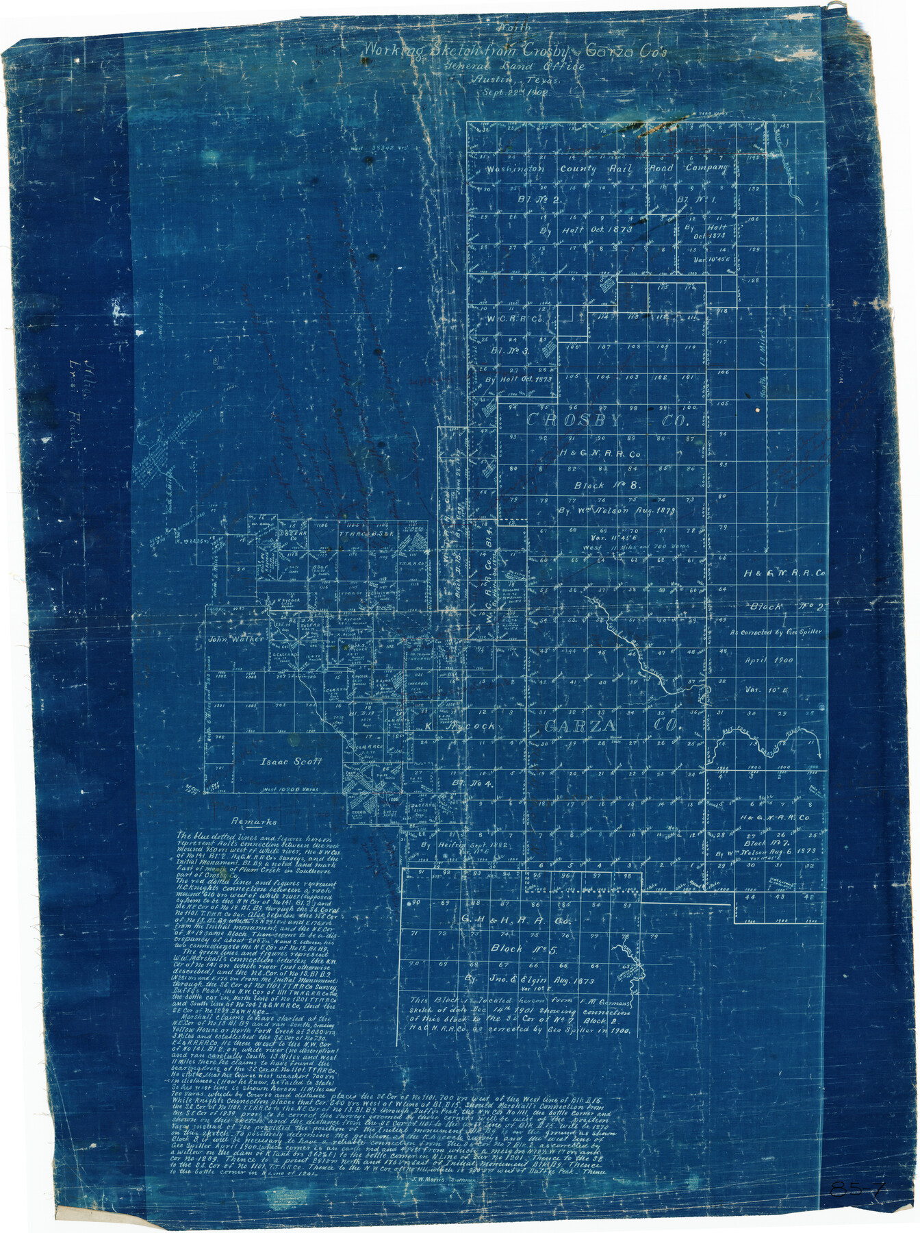
Working Sketch from Crosby and Garza Cos.
85-7
-
Map/Doc
90794
-
Collection
Twichell Survey Records
-
Object Dates
1902/9/22 (Creation Date)
-
People and Organizations
J.W. Morris (Draftsman)
-
Counties
Garza Crosby
-
Height x Width
28.7 x 38.7 inches
72.9 x 98.3 cm
Part of: Twichell Survey Records
Sylvan Sanders Survey Section 3, Block E

Print $20.00
- Digital $50.00
Sylvan Sanders Survey Section 3, Block E
1952
Size 37.4 x 24.2 inches
Map/Doc 92741
Ownership Map NE 1/4 Lubbock County [and attached letter]
![93025, Ownership Map NE 1/4 Lubbock County [and attached letter], Twichell Survey Records](https://historictexasmaps.com/wmedia_w700/maps/93025-1.tif.jpg)
Print $20.00
- Digital $50.00
Ownership Map NE 1/4 Lubbock County [and attached letter]
Size 36.3 x 39.3 inches
Map/Doc 93025
[T. C. & S. F. Block K11, Capitol Leagues 367, 373, 374, and Blocks D and B]
![90536, [T. C. & S. F. Block K11, Capitol Leagues 367, 373, 374, and Blocks D and B], Twichell Survey Records](https://historictexasmaps.com/wmedia_w700/maps/90536-1.tif.jpg)
Print $3.00
- Digital $50.00
[T. C. & S. F. Block K11, Capitol Leagues 367, 373, 374, and Blocks D and B]
1903
Size 9.5 x 13.7 inches
Map/Doc 90536
[E. T. RR. Block 1]
![93186, [E. T. RR. Block 1], Twichell Survey Records](https://historictexasmaps.com/wmedia_w700/maps/93186-1.tif.jpg)
Print $40.00
- Digital $50.00
[E. T. RR. Block 1]
Size 69.6 x 52.7 inches
Map/Doc 93186
[Sketch showing Blocks B-11, O-18, P and Mc in case of Laneer vs. Bivens]
![91727, [Sketch showing Blocks B-11, O-18, P and Mc in case of Laneer vs. Bivens], Twichell Survey Records](https://historictexasmaps.com/wmedia_w700/maps/91727-1.tif.jpg)
Print $20.00
- Digital $50.00
[Sketch showing Blocks B-11, O-18, P and Mc in case of Laneer vs. Bivens]
Size 20.9 x 18.9 inches
Map/Doc 91727
Hutchinson County, 1922

Print $20.00
- Digital $50.00
Hutchinson County, 1922
1922
Size 36.4 x 43.7 inches
Map/Doc 89700

Sketch File C, Lamb County

Print $20.00
- Digital $50.00
Sketch File C, Lamb County
1904
Size 21.6 x 26.0 inches
Map/Doc 91069
Map of Garza County, Texas

Print $20.00
- Digital $50.00
Map of Garza County, Texas
1936
Size 28.8 x 36.5 inches
Map/Doc 92650
Section 50, H. & G. N. Block 1

Print $20.00
- Digital $50.00
Section 50, H. & G. N. Block 1
Size 18.8 x 24.9 inches
Map/Doc 90816
Working Sketch Cochran and Yoakum Co's.

Print $40.00
- Digital $50.00
Working Sketch Cochran and Yoakum Co's.
1919
Size 54.2 x 14.5 inches
Map/Doc 89678
[Capitol Leagues 217-239]
![90668, [Capitol Leagues 217-239], Twichell Survey Records](https://historictexasmaps.com/wmedia_w700/maps/90668-1.tif.jpg)
Print $20.00
- Digital $50.00
[Capitol Leagues 217-239]
Size 26.9 x 26.6 inches
Map/Doc 90668
You may also like
Culberson County Rolled Sketch 54

Print $40.00
- Digital $50.00
Culberson County Rolled Sketch 54
1968
Size 59.0 x 29.4 inches
Map/Doc 10300

No. 3 Chart of Channel connecting Corpus Christi Bay with Aransas Bay, Texas

Print $20.00
- Digital $50.00
No. 3 Chart of Channel connecting Corpus Christi Bay with Aransas Bay, Texas
1878
Size 18.1 x 27.9 inches
Map/Doc 72776
[Sketch Between Hemphill County and Oklahoma]
![89664, [Sketch Between Hemphill County and Oklahoma], Twichell Survey Records](https://historictexasmaps.com/wmedia_w700/maps/89664.tif.jpg)
Print $40.00
- Digital $50.00
[Sketch Between Hemphill County and Oklahoma]
Size 8.1 x 62.5 inches
Map/Doc 89664
Duval County Sketch File 62

Print $40.00
- Digital $50.00
Duval County Sketch File 62
1941
Size 14.0 x 12.5 inches
Map/Doc 21434
Kleberg County, Cayo del Grullo

Print $20.00
- Digital $50.00
Kleberg County, Cayo del Grullo
1952
Size 32.6 x 29.0 inches
Map/Doc 73506
Fort Bend County Sketch File 20

Print $2.00
- Digital $50.00
Fort Bend County Sketch File 20
Size 8.9 x 9.4 inches
Map/Doc 22953
Hardin County Working Sketch Graphic Index

Print $20.00
- Digital $50.00
Hardin County Working Sketch Graphic Index
1940
Size 45.1 x 45.0 inches
Map/Doc 76567
Travis County Rolled Sketch 47

Print $40.00
- Digital $50.00
Travis County Rolled Sketch 47
1925
Size 24.9 x 56.8 inches
Map/Doc 10016
[I. & G. N. Block 1]
![93028, [I. & G. N. Block 1], Twichell Survey Records](https://historictexasmaps.com/wmedia_w700/maps/93028-1.tif.jpg)
Print $20.00
- Digital $50.00
[I. & G. N. Block 1]
Size 42.3 x 32.8 inches
Map/Doc 93028
Panola County Working Sketch 33

Print $40.00
- Digital $50.00
Panola County Working Sketch 33
1983
Map/Doc 71442
Bosque County Rolled Sketch 1

Print $20.00
- Digital $50.00
Bosque County Rolled Sketch 1
1978
Size 36.4 x 38.6 inches
Map/Doc 8452