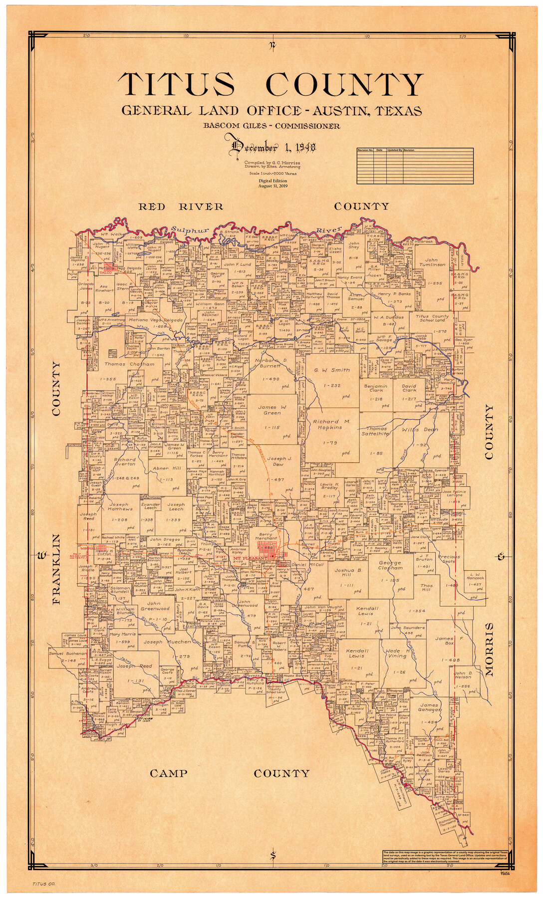
Titus County
General Land Office Official County Map
-
Map/Doc
95654
-
Collection
General Map Collection
-
Object Dates
2019/8/31 (Revision Date)
1948/12/1 (Creation Date)
-
People and Organizations
Cheyenne Betancourt (Draftsman)
Eltea Armstrong (Draftsman)
G.C. Morriss (Compiler)
Bascom Giles (GLO Commissioner)
-
Counties
Titus
-
Subjects
County OCM
-
Height x Width
41.6 x 25.2 inches
105.7 x 64.0 cm
-
Medium
digital image
-
Scale
1" = 2000 varas
Part of: General Map Collection
Duval County Sketch File 8

Print $6.00
- Digital $50.00
Duval County Sketch File 8
1869
Size 14.1 x 11.3 inches
Map/Doc 21296
Trinity County Sketch File 14

Print $4.00
- Digital $50.00
Trinity County Sketch File 14
1862
Size 8.7 x 12.0 inches
Map/Doc 38540
Martin County Working Sketch 13

Print $40.00
- Digital $50.00
Martin County Working Sketch 13
1971
Size 50.8 x 37.5 inches
Map/Doc 70831
Map of McMullen County

Print $20.00
- Digital $50.00
Map of McMullen County
1887
Size 26.8 x 18.6 inches
Map/Doc 3866
Flight Mission No. CRC-3R, Frame 56, Chambers County

Print $20.00
- Digital $50.00
Flight Mission No. CRC-3R, Frame 56, Chambers County
1956
Size 18.6 x 22.3 inches
Map/Doc 84828
Waller County Sketch File 5

Print $6.00
- Digital $50.00
Waller County Sketch File 5
Size 10.7 x 14.1 inches
Map/Doc 39600
Terry County Sketch File 20

Print $4.00
- Digital $50.00
Terry County Sketch File 20
2001
Size 11.1 x 8.8 inches
Map/Doc 76365
Hardin County Sketch File 65

Print $15.00
- Digital $50.00
Hardin County Sketch File 65
Size 14.4 x 9.0 inches
Map/Doc 25245
Moore County Rolled Sketch 9

Print $20.00
- Digital $50.00
Moore County Rolled Sketch 9
1911
Size 24.9 x 18.2 inches
Map/Doc 6827
Brewster County Rolled Sketch 147

Print $20.00
- Digital $50.00
Brewster County Rolled Sketch 147
1986
Size 24.6 x 24.8 inches
Map/Doc 5313
[T. & G. Ry. Main Line, Texas, Right of Way Map, Center to Gary]
![64568, [T. & G. Ry. Main Line, Texas, Right of Way Map, Center to Gary], General Map Collection](https://historictexasmaps.com/wmedia_w700/maps/64568-1.tif.jpg)
Print $40.00
- Digital $50.00
[T. & G. Ry. Main Line, Texas, Right of Way Map, Center to Gary]
1917
Size 31.0 x 121.2 inches
Map/Doc 64568
Ward County Working Sketch 54

Print $40.00
- Digital $50.00
Ward County Working Sketch 54
1978
Size 24.1 x 48.8 inches
Map/Doc 72360
You may also like
Garza County Rolled Sketch 9

Print $20.00
- Digital $50.00
Garza County Rolled Sketch 9
1913
Size 33.8 x 43.8 inches
Map/Doc 9054
Brooks County

Print $20.00
- Digital $50.00
Brooks County
1955
Size 42.0 x 34.2 inches
Map/Doc 73091
Industrial Site, Imperial State Prison Farm, Sugarland, Texas

Print $20.00
- Digital $50.00
Industrial Site, Imperial State Prison Farm, Sugarland, Texas
Size 26.6 x 27.5 inches
Map/Doc 73562
The Republic County of Shelby. December 29, 1845

Print $20.00
The Republic County of Shelby. December 29, 1845
2020
Size 20.0 x 21.7 inches
Map/Doc 96288

Kendall County Working Sketch 22

Print $20.00
- Digital $50.00
Kendall County Working Sketch 22
1971
Size 41.6 x 34.7 inches
Map/Doc 66694
Hudspeth County Working Sketch 32

Print $20.00
- Digital $50.00
Hudspeth County Working Sketch 32
1972
Size 21.6 x 31.7 inches
Map/Doc 66316
Pecos County Sketch File 81

Print $14.00
- Digital $50.00
Pecos County Sketch File 81
1941
Size 11.3 x 8.7 inches
Map/Doc 33920

Montague County Working Sketch 33

Print $20.00
- Digital $50.00
Montague County Working Sketch 33
1976
Size 30.6 x 43.3 inches
Map/Doc 71099
Brewster County Rolled Sketch 14

Print $20.00
- Digital $50.00
Brewster County Rolled Sketch 14
1889
Size 31.5 x 27.3 inches
Map/Doc 8469
Flight Mission No. DQO-1K, Frame 20, Galveston County

Print $20.00
- Digital $50.00
Flight Mission No. DQO-1K, Frame 20, Galveston County
1952
Size 19.0 x 22.5 inches
Map/Doc 84979