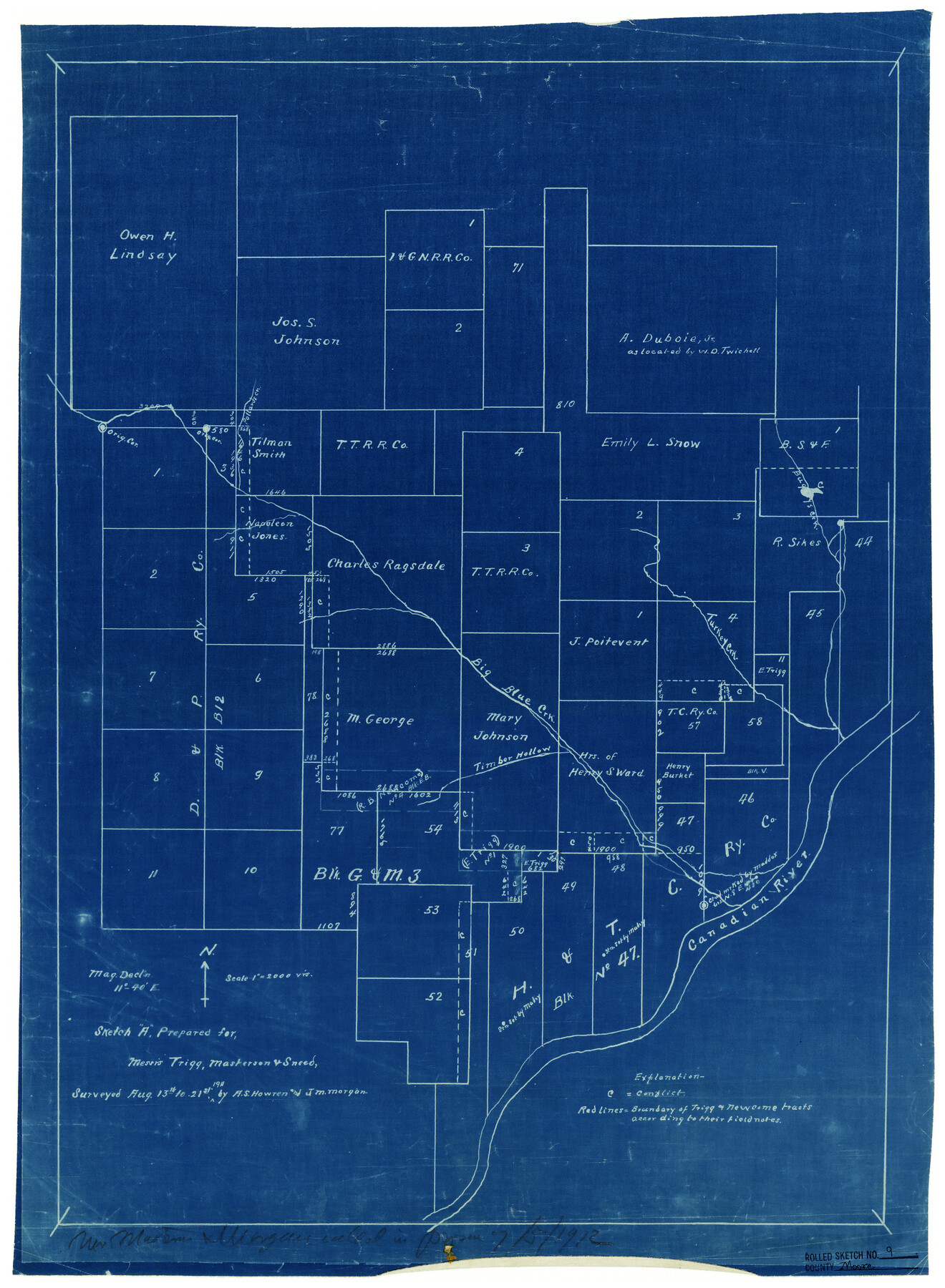
Moore County Rolled Sketch 9
[Sketch in SE part of Moore County prepared for Messrs. Trigg, Masterson, and Sneed]
-
Map/Doc
6827
-
Collection
General Map Collection
-
Object Dates
8/21/1911 (Creation Date)
7/5/1912 (File Date)
-
People and Organizations
A.S. Howren (Surveyor/Engineer)
J.M. Morgan (Surveyor/Engineer)
-
Counties
Moore
-
Subjects
Surveying Rolled Sketch
-
Height x Width
24.9 x 18.2 inches
63.3 x 46.2 cm
-
Medium
blueprint/diazo
-
Scale
1" = 2000 varas
Part of: General Map Collection
Matagorda County Rolled Sketch 15

Print $20.00
- Digital $50.00
Matagorda County Rolled Sketch 15
Size 24.5 x 14.9 inches
Map/Doc 6682
Tyler County Sketch File 6a

Print $4.00
- Digital $50.00
Tyler County Sketch File 6a
Size 10.1 x 8.0 inches
Map/Doc 38635

[Sketch for Mineral Application 19443 - Brazos River]
![65682, [Sketch for Mineral Application 19443 - Brazos River], General Map Collection](https://historictexasmaps.com/wmedia_w700/maps/65682.tif.jpg)
Print $40.00
- Digital $50.00
[Sketch for Mineral Application 19443 - Brazos River]
1853
Size 117.6 x 30.2 inches
Map/Doc 65682
Cameron County Aerial Photograph Index Sheet 7

Print $20.00
- Digital $50.00
Cameron County Aerial Photograph Index Sheet 7
1955
Size 21.8 x 16.2 inches
Map/Doc 83679
Liberty County Rolled Sketch 18

Print $11.00
- Digital $50.00
Liberty County Rolled Sketch 18
1859
Size 10.1 x 15.2 inches
Map/Doc 46540

Gregg County Rolled Sketch RG

Print $20.00
- Digital $50.00
Gregg County Rolled Sketch RG
Size 44.4 x 36.0 inches
Map/Doc 9025
Map of Comanche County

Print $40.00
- Digital $50.00
Map of Comanche County
1895
Size 47.5 x 50.0 inches
Map/Doc 4735
Jeff Davis County Rolled Sketch 26

Print $20.00
- Digital $50.00
Jeff Davis County Rolled Sketch 26
1957
Size 25.1 x 42.3 inches
Map/Doc 6374
Atascosa County Rolled Sketch 24

Print $20.00
- Digital $50.00
Atascosa County Rolled Sketch 24
Size 38.3 x 45.2 inches
Map/Doc 5101
Map of Dallas, Tarrant and part of Ellis County and Peters Colony

Print $20.00
- Digital $50.00
Map of Dallas, Tarrant and part of Ellis County and Peters Colony
1853
Size 25.8 x 32.0 inches
Map/Doc 1970
You may also like
Harris County

Print $40.00
- Digital $50.00
Harris County
1896
Size 44.4 x 69.3 inches
Map/Doc 66857
Bosque County Sketch File 21

Print $12.00
- Digital $50.00
Bosque County Sketch File 21
1863
Size 10.9 x 8.7 inches
Map/Doc 14798
Baylor County Working Sketch 4

Print $20.00
- Digital $50.00
Baylor County Working Sketch 4
1938
Size 30.4 x 21.0 inches
Map/Doc 67289
Colorado County Working Sketch 5

Print $40.00
- Digital $50.00
Colorado County Working Sketch 5
1919
Size 82.4 x 44.1 inches
Map/Doc 68105
Map of the Northeast part of the Pitchfork Ranch

Print $20.00
- Digital $50.00
Map of the Northeast part of the Pitchfork Ranch
1916
Size 23.2 x 23.6 inches
Map/Doc 91046
Padre Island National Seashore

Print $4.00
- Digital $50.00
Padre Island National Seashore
Size 16.1 x 22.3 inches
Map/Doc 60538
Map of Orange County

Print $20.00
- Digital $50.00
Map of Orange County
1895
Size 15.5 x 16.2 inches
Map/Doc 3932
Rusk County Working Sketch 10

Print $20.00
- Digital $50.00
Rusk County Working Sketch 10
1980
Size 22.4 x 20.6 inches
Map/Doc 63645
Maps of Gulf Intracoastal Waterway, Texas - Sabine River to the Rio Grande and connecting waterways including ship channels

Print $20.00
- Digital $50.00
Maps of Gulf Intracoastal Waterway, Texas - Sabine River to the Rio Grande and connecting waterways including ship channels
1966
Size 14.6 x 20.7 inches
Map/Doc 61999
Flight Mission No. CGI-1N, Frame 139, Cameron County

Print $20.00
- Digital $50.00
Flight Mission No. CGI-1N, Frame 139, Cameron County
1955
Size 18.6 x 22.2 inches
Map/Doc 84495
T. C. Ivey Ranch, Block D, Yoakum Co., Texas

Print $20.00
- Digital $50.00
T. C. Ivey Ranch, Block D, Yoakum Co., Texas
Size 17.1 x 14.6 inches
Map/Doc 91976
Denton County Sketch File 1

Print $2.00
- Digital $50.00
Denton County Sketch File 1
Size 8.4 x 10.6 inches
Map/Doc 20681