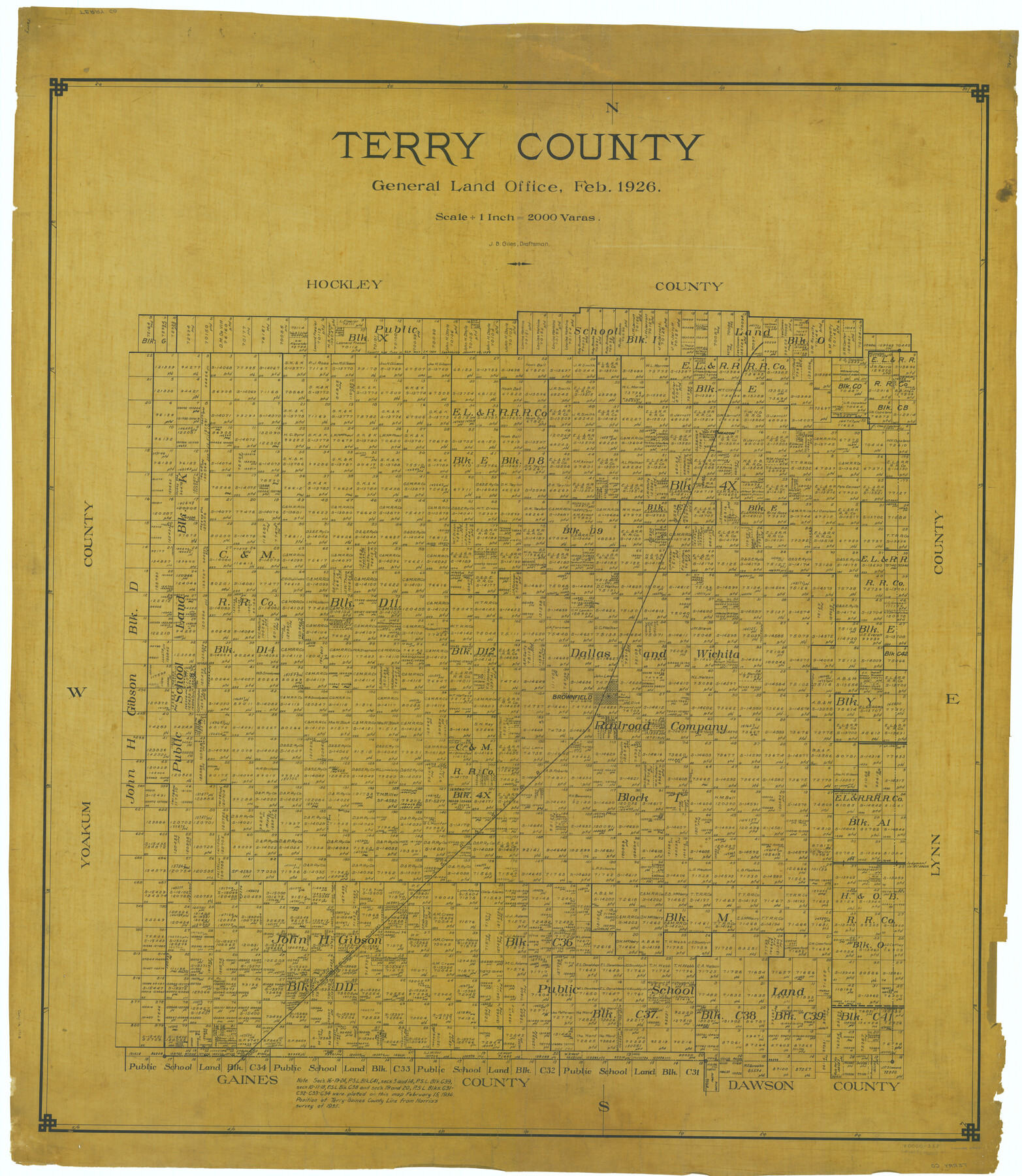
Terry County
-
Map/Doc
63063
-
Collection
General Map Collection
-
Object Dates
1926 (Creation Date)
-
People and Organizations
Texas General Land Office (Publisher)
J. Bascom Giles (Draftsman)
J. Bascom Giles (Compiler)
-
Counties
Terry
-
Subjects
County
-
Height x Width
46.5 x 40.4 inches
118.1 x 102.6 cm
Part of: General Map Collection
Reagan County Sketch File 35

Print $6.00
- Digital $50.00
Reagan County Sketch File 35
1962
Size 14.4 x 8.7 inches
Map/Doc 35032
Orange County Working Sketch 45

Print $20.00
- Digital $50.00
Orange County Working Sketch 45
1982
Size 25.6 x 24.2 inches
Map/Doc 71377

Cottle County

Print $20.00
- Digital $50.00
Cottle County
1971
Size 41.5 x 33.3 inches
Map/Doc 77250
Flight Mission No. BQR-4K, Frame 71, Brazoria County

Print $20.00
- Digital $50.00
Flight Mission No. BQR-4K, Frame 71, Brazoria County
1952
Size 18.8 x 22.4 inches
Map/Doc 84004
Morris County Rolled Sketch 2A

Print $20.00
- Digital $50.00
Morris County Rolled Sketch 2A
Size 24.3 x 19.2 inches
Map/Doc 10264
Liberty County Working Sketch 21

Print $20.00
- Digital $50.00
Liberty County Working Sketch 21
1940
Size 20.1 x 15.0 inches
Map/Doc 70480
Blanco County Sketch File 23

Print $16.00
- Digital $50.00
Blanco County Sketch File 23
1887
Size 8.7 x 14.1 inches
Map/Doc 14606
Map of Bosque County

Print $20.00
- Digital $50.00
Map of Bosque County
1869
Size 24.1 x 23.7 inches
Map/Doc 3313
Flight Mission No. DAG-21K, Frame 130, Matagorda County

Print $20.00
- Digital $50.00
Flight Mission No. DAG-21K, Frame 130, Matagorda County
1952
Size 18.5 x 22.4 inches
Map/Doc 86456
Presidio County Working Sketch 64

Print $40.00
- Digital $50.00
Presidio County Working Sketch 64
1958
Size 50.2 x 37.5 inches
Map/Doc 71741
United States - Gulf Coast - Galveston to Rio Grande

Print $20.00
- Digital $50.00
United States - Gulf Coast - Galveston to Rio Grande
Size 27.9 x 18.3 inches
Map/Doc 72742
You may also like
Copy of Surveyor's Field Book, Morris Browning - In Blocks 7, 5 & 4, I&GNRRCo., Hutchinson and Carson Counties, Texas

Print $2.00
- Digital $50.00
Copy of Surveyor's Field Book, Morris Browning - In Blocks 7, 5 & 4, I&GNRRCo., Hutchinson and Carson Counties, Texas
1888
Size 6.9 x 8.8 inches
Map/Doc 62271
Map of Townsite of Swearingen, Cottle County, Texas

Print $20.00
- Digital $50.00
Map of Townsite of Swearingen, Cottle County, Texas
1919
Size 28.1 x 17.1 inches
Map/Doc 4463
El Paso County Boundary File 22

Print $4.00
- Digital $50.00
El Paso County Boundary File 22
Size 13.6 x 8.6 inches
Map/Doc 53216
Wharton County Sketch File A3

Print $26.00
- Digital $50.00
Wharton County Sketch File A3
1899
Size 18.2 x 18.6 inches
Map/Doc 12671
Kleberg County Rolled Sketch 10-34

Print $20.00
- Digital $50.00
Kleberg County Rolled Sketch 10-34
1952
Size 38.2 x 32.3 inches
Map/Doc 9384
Nolan County Rolled Sketch 2

Print $20.00
- Digital $50.00
Nolan County Rolled Sketch 2
1956
Size 27.7 x 35.0 inches
Map/Doc 6860
Webb County Rolled Sketch 52

Print $20.00
- Digital $50.00
Webb County Rolled Sketch 52
1943
Size 37.8 x 29.3 inches
Map/Doc 8205
[Surveys in the Jefferson District]
![69726, [Surveys in the Jefferson District], General Map Collection](https://historictexasmaps.com/wmedia_w700/maps/69726-1.tif.jpg)
Print $20.00
- Digital $50.00
[Surveys in the Jefferson District]
1841
Size 14.6 x 21.2 inches
Map/Doc 69726
[Capitol Leagues in Lamb County]
![91014, [Capitol Leagues in Lamb County], Twichell Survey Records](https://historictexasmaps.com/wmedia_w700/maps/91014-1.tif.jpg)
Print $2.00
- Digital $50.00
[Capitol Leagues in Lamb County]
1912
Size 12.7 x 8.8 inches
Map/Doc 91014
Terrell County Rolled Sketch 9

Print $20.00
- Digital $50.00
Terrell County Rolled Sketch 9
Size 17.6 x 42.9 inches
Map/Doc 7925
Burnet County Working Sketch 5

Print $20.00
- Digital $50.00
Burnet County Working Sketch 5
1956
Size 30.0 x 19.3 inches
Map/Doc 67848
Flight Mission No. DCL-7C, Frame 41, Kenedy County

Print $20.00
- Digital $50.00
Flight Mission No. DCL-7C, Frame 41, Kenedy County
1943
Size 15.4 x 15.2 inches
Map/Doc 86029