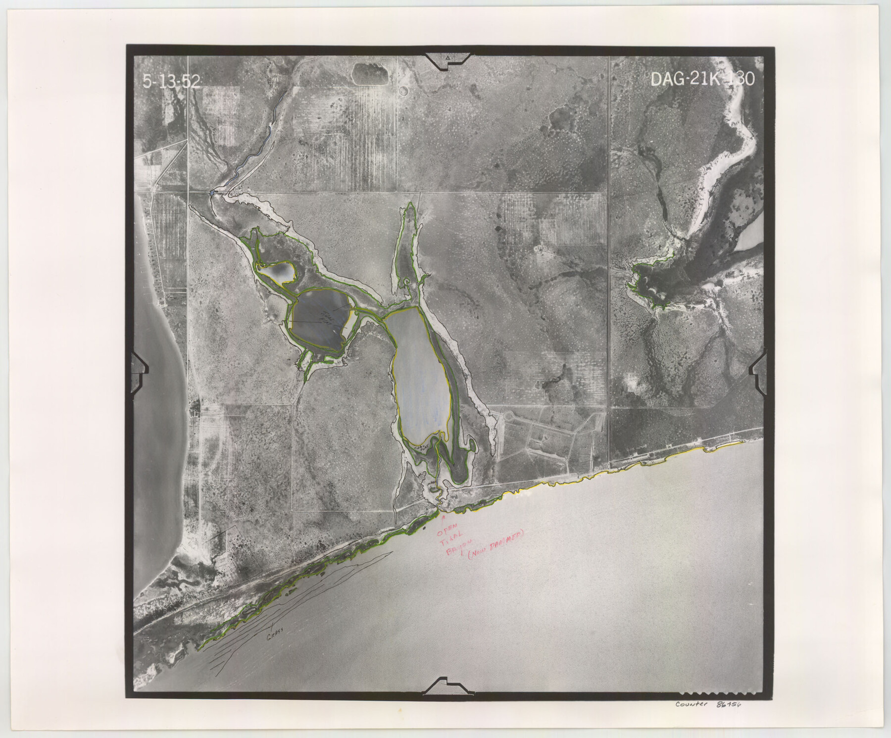
Flight Mission No. DAG-21K, Frame 130, Matagorda County
DAG-21K-130
-
Map/Doc
86456
-
Collection
General Map Collection
-
Object Dates
1952/5/13 (Creation Date)
-
People and Organizations
U. S. Department of Agriculture (Publisher)
-
Counties
Matagorda
-
Subjects
Aerial Photograph
-
Height x Width
18.5 x 22.4 inches
47.0 x 56.9 cm
-
Comments
Flown by Aero Exploration Company of Tulsa, Oklahoma.
Part of: General Map Collection
Castro County Sketch File 13

Print $4.00
- Digital $50.00
Castro County Sketch File 13
1962
Size 14.1 x 8.6 inches
Map/Doc 17509
Reagan County Working Sketch 13

Print $40.00
- Digital $50.00
Reagan County Working Sketch 13
1948
Size 23.8 x 50.8 inches
Map/Doc 71853
Current Miscellaneous File 97

Print $16.00
- Digital $50.00
Current Miscellaneous File 97
1847
Size 11.3 x 8.8 inches
Map/Doc 74329
Presidio County Working Sketch 109

Print $20.00
- Digital $50.00
Presidio County Working Sketch 109
1980
Size 23.3 x 21.4 inches
Map/Doc 71786
Corpus Christi Harbor

Print $40.00
- Digital $50.00
Corpus Christi Harbor
1975
Size 37.6 x 51.5 inches
Map/Doc 73479
Trinity River, Daugherty Lake Sheet/East Fork of Trinity River

Print $20.00
- Digital $50.00
Trinity River, Daugherty Lake Sheet/East Fork of Trinity River
1920
Size 41.9 x 30.1 inches
Map/Doc 65191
Blanco County Working Sketch 16

Print $20.00
- Digital $50.00
Blanco County Working Sketch 16
1951
Size 22.2 x 19.5 inches
Map/Doc 67376
Hardin County Working Sketch 31

Print $20.00
- Digital $50.00
Hardin County Working Sketch 31
1971
Size 43.0 x 33.2 inches
Map/Doc 63429
Wilson County Sketch File 10

Print $4.00
- Digital $50.00
Wilson County Sketch File 10
Size 6.7 x 6.2 inches
Map/Doc 40417
Map of Jefferson County

Print $20.00
- Digital $50.00
Map of Jefferson County
1896
Size 26.7 x 23.2 inches
Map/Doc 66883
Flight Mission No. DQN-3K, Frame 6, Calhoun County

Print $20.00
- Digital $50.00
Flight Mission No. DQN-3K, Frame 6, Calhoun County
1953
Size 18.4 x 22.2 inches
Map/Doc 84338
Goliad County Sketch File 28

Print $20.00
- Digital $50.00
Goliad County Sketch File 28
Size 18.9 x 15.5 inches
Map/Doc 11569
You may also like
McCulloch County Sketch File 6

Print $20.00
- Digital $50.00
McCulloch County Sketch File 6
1893
Size 44.2 x 19.3 inches
Map/Doc 10539
Red River County Sketch File 14

Print $8.00
- Digital $50.00
Red River County Sketch File 14
Size 13.7 x 9.0 inches
Map/Doc 35133
McMullen County Sketch File 19

Print $4.00
- Digital $50.00
McMullen County Sketch File 19
Size 12.8 x 8.1 inches
Map/Doc 31371
Map of Retrieve Plantation, Brazoria County, Texas

Print $20.00
- Digital $50.00
Map of Retrieve Plantation, Brazoria County, Texas
Size 26.6 x 28.5 inches
Map/Doc 62999
[Surveys in Milam's Colony between the Colorado River and northwest of the San Antonio Road]
![29, [Surveys in Milam's Colony between the Colorado River and northwest of the San Antonio Road], General Map Collection](https://historictexasmaps.com/wmedia_w700/maps/29-1.tif.jpg)
Print $20.00
- Digital $50.00
[Surveys in Milam's Colony between the Colorado River and northwest of the San Antonio Road]
Size 22.0 x 27.4 inches
Map/Doc 29
[Sketch for Mineral Application 26501 - Sabine River, T. A. Oldhausen]
![2845, [Sketch for Mineral Application 26501 - Sabine River, T. A. Oldhausen], General Map Collection](https://historictexasmaps.com/wmedia_w700/maps/2845.tif.jpg)
Print $20.00
- Digital $50.00
[Sketch for Mineral Application 26501 - Sabine River, T. A. Oldhausen]
1931
Size 24.0 x 36.9 inches
Map/Doc 2845
In the Supreme Court of the United States The State of Oklahoma, Complainant vs. The State of Texas, Defendant, The United States of America, Intervener - 1920

Print $20.00
- Digital $50.00
In the Supreme Court of the United States The State of Oklahoma, Complainant vs. The State of Texas, Defendant, The United States of America, Intervener - 1920
1920
Size 39.4 x 35.6 inches
Map/Doc 75111
Val Verde County Working Sketch 52

Print $20.00
- Digital $50.00
Val Verde County Working Sketch 52
1956
Size 20.6 x 14.9 inches
Map/Doc 72187
El Paso County Sketch File 13

Print $8.00
- Digital $50.00
El Paso County Sketch File 13
1905
Size 7.4 x 6.8 inches
Map/Doc 22005
Plat Showing Proposed Dam & Reservoir Under Application No. 561 Located at Mouth of Clear Fork of Brazos River

Print $20.00
- Digital $50.00
Plat Showing Proposed Dam & Reservoir Under Application No. 561 Located at Mouth of Clear Fork of Brazos River
1921
Size 24.0 x 16.6 inches
Map/Doc 92094
Uvalde County Working Sketch 39

Print $20.00
- Digital $50.00
Uvalde County Working Sketch 39
1975
Size 28.0 x 45.3 inches
Map/Doc 72109
Location of the Southern Kansas Railway of Texas, Carson County, Texas

Print $40.00
- Digital $50.00
Location of the Southern Kansas Railway of Texas, Carson County, Texas
1887
Size 20.5 x 84.3 inches
Map/Doc 64035