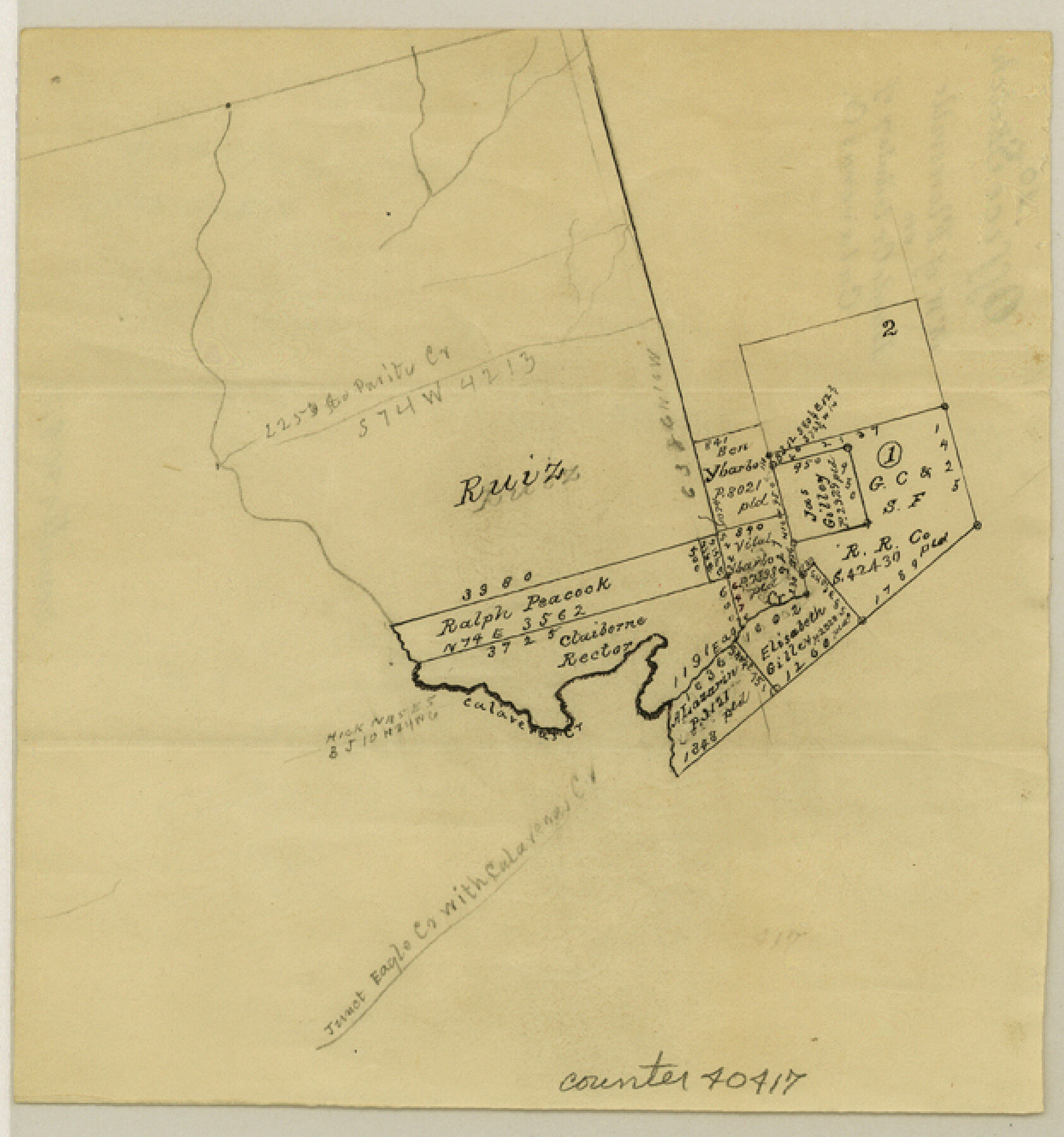
Wilson County Sketch File 10
[Sketch of area northwest of Floresville on Eagle Creek, tributary of Calaveras Creek]
-
Map/Doc
40417
-
Collection
General Map Collection
-
Object Dates
No date given
-
Counties
Wilson
-
Subjects
Surveying Sketch File
-
Height x Width
6.7 x 6.2 inches
17.0 x 15.8 cm
-
Medium
paper, manuscript
-
Scale
No scale given
-
Features
Calaveras Creek
Eagle Creek
Part of: General Map Collection
Karnes County Sketch File 14

Print $6.00
- Digital $50.00
Karnes County Sketch File 14
1897
Size 9.7 x 6.2 inches
Map/Doc 28615
Webb County Working Sketch 3

Print $20.00
- Digital $50.00
Webb County Working Sketch 3
1906
Size 18.2 x 27.2 inches
Map/Doc 72368
Pecos County Sketch File 60

Print $6.00
- Digital $50.00
Pecos County Sketch File 60
Size 8.2 x 16.5 inches
Map/Doc 33786
Blanco County Sketch File 25

Print $40.00
- Digital $50.00
Blanco County Sketch File 25
1888
Size 17.1 x 14.2 inches
Map/Doc 14616
Hill County Sketch File 1

Print $4.00
- Digital $50.00
Hill County Sketch File 1
1857
Size 9.0 x 7.9 inches
Map/Doc 26459
Goliad County Sketch File 13

Print $8.00
- Digital $50.00
Goliad County Sketch File 13
1856
Size 12.4 x 8.0 inches
Map/Doc 24239
Cooke County Rolled Sketch 4

Print $20.00
- Digital $50.00
Cooke County Rolled Sketch 4
Size 18.1 x 23.1 inches
Map/Doc 5562
Anderson County

Print $40.00
- Digital $50.00
Anderson County
1942
Size 52.9 x 47.9 inches
Map/Doc 66702
Bosque County Sketch File 16

Print $14.00
- Digital $50.00
Bosque County Sketch File 16
Size 13.0 x 7.9 inches
Map/Doc 14781
Flight Mission No. CGI-1N, Frame 185, Cameron County

Print $20.00
- Digital $50.00
Flight Mission No. CGI-1N, Frame 185, Cameron County
1955
Size 18.6 x 22.2 inches
Map/Doc 84520

Map of the Town of Harrold, Wilbarger County, Texas on the line of the Fort Worth and Denver City Railway

Print $20.00
- Digital $50.00
Map of the Town of Harrold, Wilbarger County, Texas on the line of the Fort Worth and Denver City Railway
1887
Size 31.2 x 28.6 inches
Map/Doc 2186
You may also like
Uvalde County Working Sketch 19

Print $20.00
- Digital $50.00
Uvalde County Working Sketch 19
1948
Size 25.8 x 39.8 inches
Map/Doc 72089
Nueces County Rolled Sketch 110A

Print $20.00
- Digital $50.00
Nueces County Rolled Sketch 110A
1990
Size 24.3 x 37.5 inches
Map/Doc 7118
Andrews County Rolled Sketch 9

Print $20.00
- Digital $50.00
Andrews County Rolled Sketch 9
1930
Size 25.3 x 43.6 inches
Map/Doc 77160
[West half of County]
![89961, [West half of County], Twichell Survey Records](https://historictexasmaps.com/wmedia_w700/maps/89961-1.tif.jpg)
Print $40.00
- Digital $50.00
[West half of County]
1914
Size 40.0 x 62.5 inches
Map/Doc 89961
Flight Mission No. BRA-16M, Frame 107, Jefferson County

Print $20.00
- Digital $50.00
Flight Mission No. BRA-16M, Frame 107, Jefferson County
1953
Size 18.5 x 22.3 inches
Map/Doc 85719
Hemphill County

Print $20.00
- Digital $50.00
Hemphill County
1888
Size 23.9 x 18.3 inches
Map/Doc 3653
Briscoe County Sketch File F

Print $40.00
- Digital $50.00
Briscoe County Sketch File F
1917
Size 20.9 x 19.3 inches
Map/Doc 76756
Kerr County Boundary File 5

Print $8.00
- Digital $50.00
Kerr County Boundary File 5
Size 14.2 x 8.7 inches
Map/Doc 64818
Nueces County Sketch File 26a

Print $14.00
- Digital $50.00
Nueces County Sketch File 26a
1894
Size 12.6 x 7.9 inches
Map/Doc 32581
Taylor County Sketch File A

Print $2.00
- Digital $50.00
Taylor County Sketch File A
Size 8.8 x 11.3 inches
Map/Doc 37773
General Highway Map, Montague County, Texas

Print $20.00
General Highway Map, Montague County, Texas
1940
Size 24.9 x 18.3 inches
Map/Doc 79201