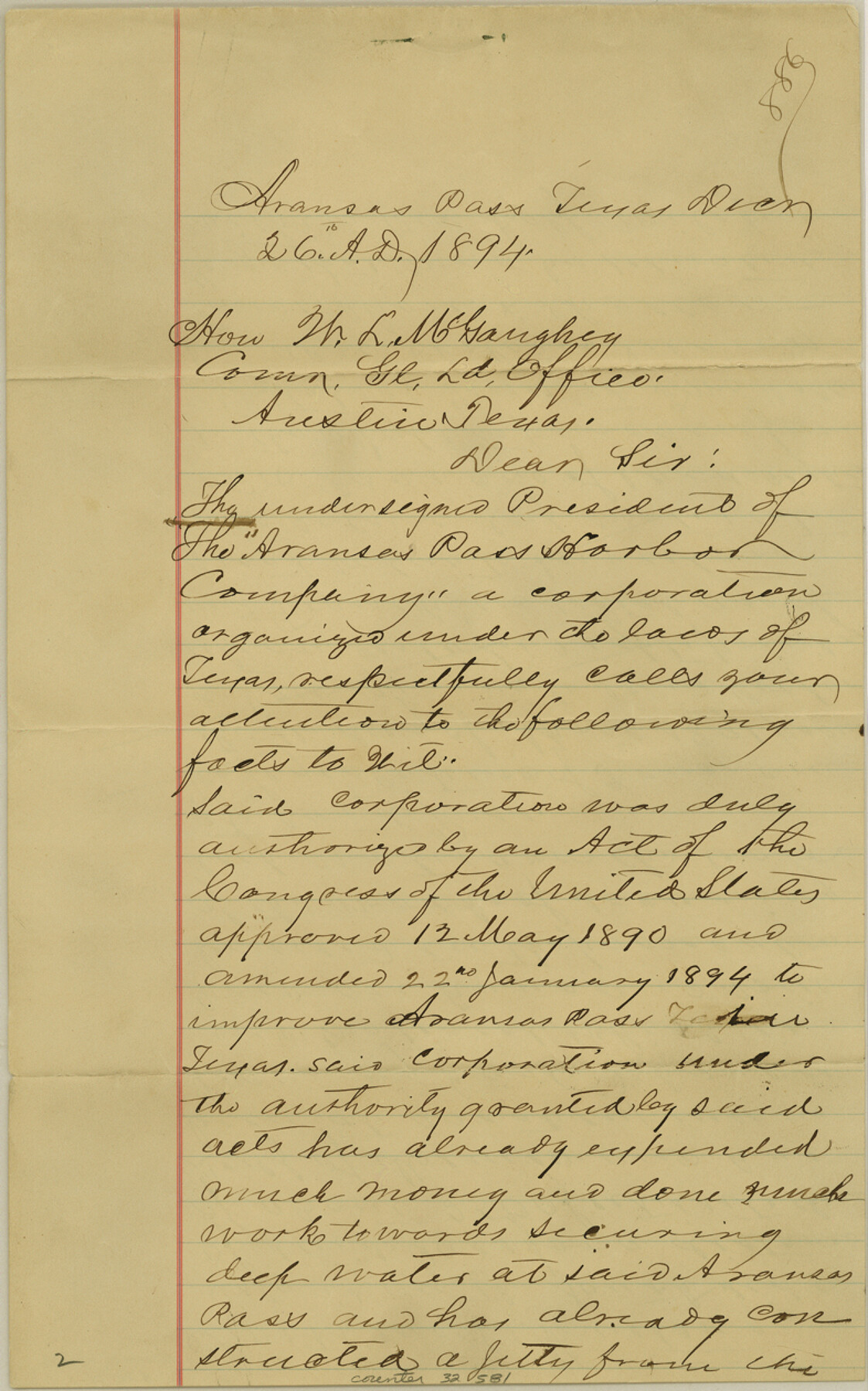
Nueces County Sketch File 26a
[Protest regarding north end of Mustang Island]
-
Map/Doc
32581
-
Collection
General Map Collection
-
Object Dates
12/26/1894 (Creation Date)
1/4/1895 (File Date)
12/26/1894 (Correspondence Date)
-
People and Organizations
T.B. Wheeler (President)
-
Counties
Nueces
-
Subjects
Surveying Sketch File
-
Height x Width
12.6 x 7.9 inches
32.0 x 20.1 cm
-
Medium
paper, manuscript
-
Features
Aransas Pass
Mustang Island
Gulf of Mexico
Part of: General Map Collection
Bee County Sketch File 23

Print $8.00
- Digital $50.00
Bee County Sketch File 23
1878
Size 10.0 x 8.1 inches
Map/Doc 14318
Jefferson County Working Sketch 13

Print $20.00
- Digital $50.00
Jefferson County Working Sketch 13
1948
Size 13.5 x 20.1 inches
Map/Doc 66556
Webb County Rolled Sketch EF3

Print $20.00
- Digital $50.00
Webb County Rolled Sketch EF3
Size 24.1 x 27.0 inches
Map/Doc 8225
Bee County Sketch File 7

Print $8.00
- Digital $50.00
Bee County Sketch File 7
1873
Size 10.1 x 8.0 inches
Map/Doc 14275
Henderson County

Print $40.00
- Digital $50.00
Henderson County
1922
Size 33.0 x 62.7 inches
Map/Doc 66861
Hardin County Sketch File 36

Print $4.00
- Digital $50.00
Hardin County Sketch File 36
Size 12.5 x 8.1 inches
Map/Doc 25178
Borden County Rolled Sketch 12

Print $40.00
- Digital $50.00
Borden County Rolled Sketch 12
1964
Size 48.1 x 31.6 inches
Map/Doc 8451
Burnet County Sketch File 46

Print $4.00
- Digital $50.00
Burnet County Sketch File 46
1873
Size 12.8 x 8.5 inches
Map/Doc 16773
Houston County Sketch File 6a

Print $4.00
- Digital $50.00
Houston County Sketch File 6a
Size 10.2 x 8.1 inches
Map/Doc 26762
Wichita County Sketch File R

Print $8.00
- Digital $50.00
Wichita County Sketch File R
Size 14.3 x 8.8 inches
Map/Doc 40142
Flight Mission No. CLL-3N, Frame 7, Willacy County

Print $20.00
- Digital $50.00
Flight Mission No. CLL-3N, Frame 7, Willacy County
1954
Size 18.4 x 22.1 inches
Map/Doc 87073
Val Verde County Working Sketch 51

Print $20.00
- Digital $50.00
Val Verde County Working Sketch 51
1952
Size 24.5 x 30.0 inches
Map/Doc 72186
You may also like
Bexar County Working Sketch 13

Print $20.00
- Digital $50.00
Bexar County Working Sketch 13
1968
Size 43.5 x 43.7 inches
Map/Doc 67329
Liberty County Rolled Sketch 15

Print $20.00
- Digital $50.00
Liberty County Rolled Sketch 15
2015
Size 36.2 x 24.5 inches
Map/Doc 94024
Pecos County Sketch File 111

Print $18.00
- Digital $50.00
Pecos County Sketch File 111
Size 13.3 x 8.8 inches
Map/Doc 34052
Terrell County Working Sketch 21

Print $20.00
- Digital $50.00
Terrell County Working Sketch 21
1935
Size 24.0 x 17.9 inches
Map/Doc 62171
Gaines County Sketch File 1

Print $20.00
- Digital $50.00
Gaines County Sketch File 1
Size 19.1 x 30.7 inches
Map/Doc 11521
Blocks 2, 8, and 9. Capitol Syndicate Subdivision of Capitol Leagues or Portions of Capitol Leagues 59, 60, 61, 62, 63, 64, 65, 66, 69, 70, 71, 72, 73, 74, 75, 76, 83, 84, 85, 86, 87, 88, 89, 90, 91, 92, 108, 109, and 110. Dallam County, Texas

Print $20.00
- Digital $50.00
Blocks 2, 8, and 9. Capitol Syndicate Subdivision of Capitol Leagues or Portions of Capitol Leagues 59, 60, 61, 62, 63, 64, 65, 66, 69, 70, 71, 72, 73, 74, 75, 76, 83, 84, 85, 86, 87, 88, 89, 90, 91, 92, 108, 109, and 110. Dallam County, Texas
1906
Size 31.7 x 28.3 inches
Map/Doc 92581
Floyd County Sketch File 32a

Print $20.00
- Digital $50.00
Floyd County Sketch File 32a
1952
Size 36.5 x 33.1 inches
Map/Doc 10451
Martin County Sketch File 4

Print $20.00
- Digital $50.00
Martin County Sketch File 4
Size 26.9 x 19.8 inches
Map/Doc 12027
Terry County Rolled Sketch 2

Print $20.00
- Digital $50.00
Terry County Rolled Sketch 2
1908
Size 25.5 x 36.8 inches
Map/Doc 7980
Plan of the City of Austin

Print $20.00
Plan of the City of Austin
1839
Size 24.2 x 19.4 inches
Map/Doc 76204
Tarrant County Sketch File 10

Print $8.00
- Digital $50.00
Tarrant County Sketch File 10
1859
Size 12.9 x 8.4 inches
Map/Doc 37694
Dimmit County Working Sketch 45

Print $20.00
- Digital $50.00
Dimmit County Working Sketch 45
1979
Size 44.7 x 35.5 inches
Map/Doc 68706