Wichita County Sketch File R
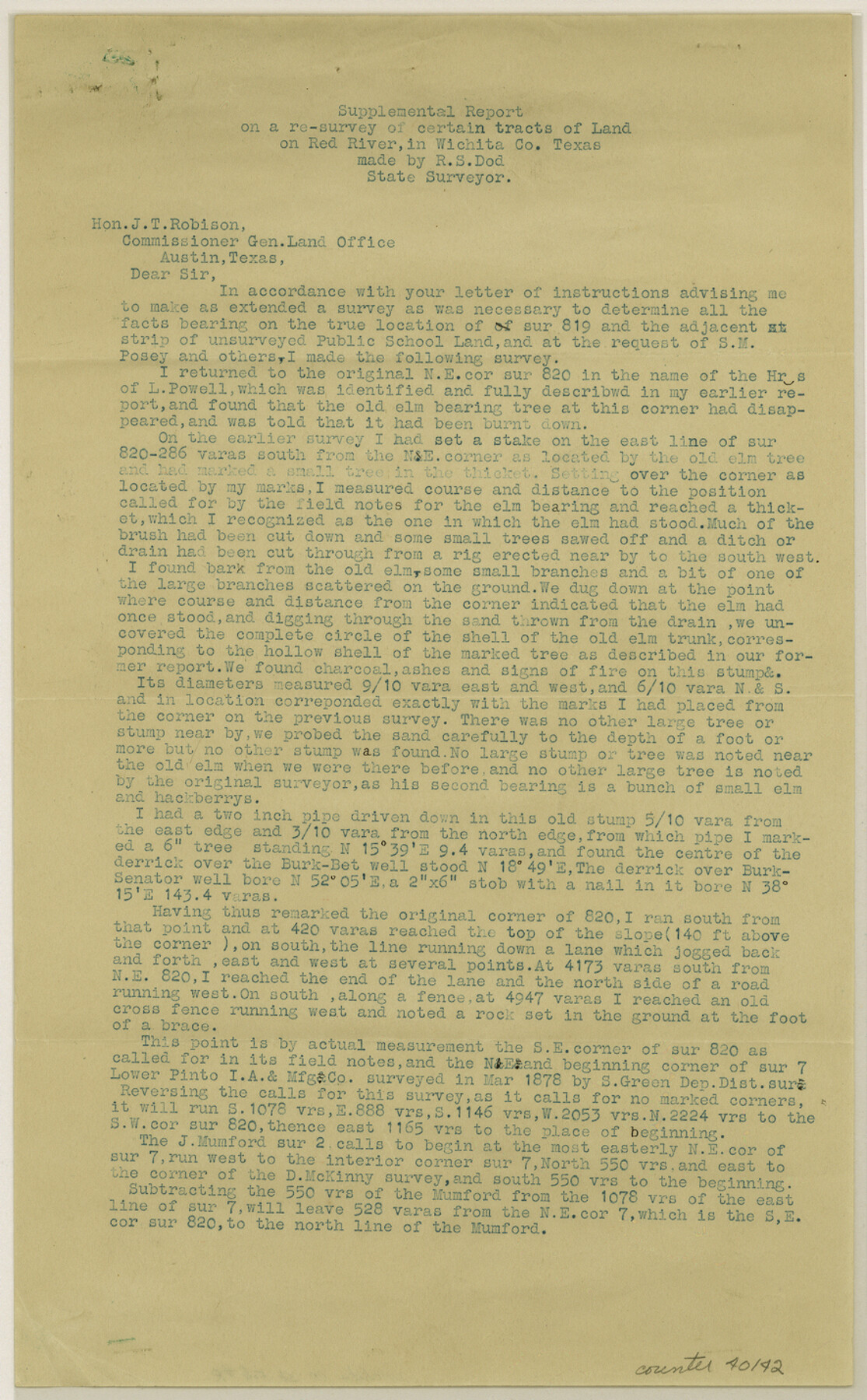
[Supplemental report on a resurvey made to determine the location of survey 819 and adjacent surveys in the north part of the county]
-
Map/Doc
40142
-
Collection
General Map Collection
-
Object Dates
2/7/1920 (File Date)
-
People and Organizations
R.S. Dod (Surveyor/Engineer)
-
Counties
Wichita
-
Subjects
Surveying Sketch File
-
Height x Width
14.3 x 8.8 inches
36.3 x 22.4 cm
-
Medium
paper, print
-
Comments
See Wichita County Sketch File D (40061) for original report.
See Wichita County Rolled Sketch 13 (8250) for sketch. -
Features
Red River
Clara & Burkburnet Road
Related maps
Wichita County Sketch File D

Print $22.00
- Digital $50.00
Wichita County Sketch File D
1919
Size 12.0 x 8.6 inches
Map/Doc 40061
Wichita County Rolled Sketch 13

Print $20.00
- Digital $50.00
Wichita County Rolled Sketch 13
Size 25.7 x 16.6 inches
Map/Doc 8250
Part of: General Map Collection

Galveston County NRC Article 33.136 Location Key Sheet

Print $20.00
- Digital $50.00
Galveston County NRC Article 33.136 Location Key Sheet
1974
Size 27.0 x 23.0 inches
Map/Doc 77025
Reeves County

Print $40.00
- Digital $50.00
Reeves County
1915
Size 48.4 x 38.7 inches
Map/Doc 66999
Hamilton County Sketch File 10 1/2

Print $44.00
- Digital $50.00
Hamilton County Sketch File 10 1/2
1876
Size 9.2 x 8.3 inches
Map/Doc 24931
Dimmit County Sketch File 55

Print $20.00
- Digital $50.00
Dimmit County Sketch File 55
1926
Size 23.1 x 15.7 inches
Map/Doc 11359
Ochiltree County Working Sketch 6

Print $20.00
- Digital $50.00
Ochiltree County Working Sketch 6
1962
Size 31.1 x 22.9 inches
Map/Doc 71319
Flight Mission No. BQR-12K, Frame 47, Brazoria County

Print $20.00
- Digital $50.00
Flight Mission No. BQR-12K, Frame 47, Brazoria County
1952
Size 18.7 x 22.4 inches
Map/Doc 84062
Map of the County of Nueces and portions of adjoining counties showing the locality, dates and claimants of the several grants made by the government of Spain and Mexico

Print $20.00
- Digital $50.00
Map of the County of Nueces and portions of adjoining counties showing the locality, dates and claimants of the several grants made by the government of Spain and Mexico
1859
Size 37.3 x 39.0 inches
Map/Doc 4677
Tyler County Sketch File 9a

Print $4.00
- Digital $50.00
Tyler County Sketch File 9a
1877
Size 8.1 x 7.7 inches
Map/Doc 38646
Flight Mission No. CLL-3N, Frame 35, Willacy County

Print $20.00
- Digital $50.00
Flight Mission No. CLL-3N, Frame 35, Willacy County
1954
Size 18.3 x 22.1 inches
Map/Doc 87093
Lipscomb County Boundary File 1

Print $16.00
- Digital $50.00
Lipscomb County Boundary File 1
Size 9.0 x 8.0 inches
Map/Doc 56307
Fayette County Boundary File 8

Print $19.00
- Digital $50.00
Fayette County Boundary File 8
Size 14.4 x 9.0 inches
Map/Doc 53402
You may also like
Zavala County Sketch File 10a

Print $6.00
- Digital $50.00
Zavala County Sketch File 10a
1885
Size 14.6 x 8.8 inches
Map/Doc 41267
Pecos County Sketch File 24

Print $22.00
- Digital $50.00
Pecos County Sketch File 24
Size 7.6 x 5.6 inches
Map/Doc 33680
Map of Rock Island Lines and Connections - Route of Golden State Limited to California / Rocky Mountain Limited to Colorado

Print $20.00
- Digital $50.00
Map of Rock Island Lines and Connections - Route of Golden State Limited to California / Rocky Mountain Limited to Colorado
1923
Size 18.3 x 32.6 inches
Map/Doc 95890
[Sketch N, showing Blocks C-10, C-14 through C-16]
![91772, [Sketch N, showing Blocks C-10, C-14 through C-16], Twichell Survey Records](https://historictexasmaps.com/wmedia_w700/maps/91772-1.tif.jpg)
Print $20.00
- Digital $50.00
[Sketch N, showing Blocks C-10, C-14 through C-16]
Size 38.6 x 22.1 inches
Map/Doc 91772
Roberts County Working Sketch 19

Print $20.00
- Digital $50.00
Roberts County Working Sketch 19
1975
Size 30.7 x 39.9 inches
Map/Doc 63545
Flight Mission No. CLL-3N, Frame 43, Willacy County

Print $20.00
- Digital $50.00
Flight Mission No. CLL-3N, Frame 43, Willacy County
1954
Size 18.3 x 22.0 inches
Map/Doc 87101
Flight Mission No. CLL-4N, Frame 31, Willacy County

Print $20.00
- Digital $50.00
Flight Mission No. CLL-4N, Frame 31, Willacy County
1954
Size 18.4 x 22.1 inches
Map/Doc 87104
Section M, Tech Memorial Park, Inc.

Print $2.00
- Digital $50.00
Section M, Tech Memorial Park, Inc.
1950
Size 7.6 x 11.8 inches
Map/Doc 92271
Dickens County, Texas

Print $20.00
- Digital $50.00
Dickens County, Texas
1883
Size 22.4 x 18.6 inches
Map/Doc 722
Cottle County Sketch File 7 1/2

Print $26.00
- Digital $50.00
Cottle County Sketch File 7 1/2
1889
Size 40.2 x 21.0 inches
Map/Doc 10342
Hardeman County Sketch File 2

Print $6.00
- Digital $50.00
Hardeman County Sketch File 2
1879
Size 9.0 x 7.7 inches
Map/Doc 24984
Taylor County Working Sketch 2

Print $20.00
- Digital $50.00
Taylor County Working Sketch 2
1930
Size 27.3 x 23.1 inches
Map/Doc 69611