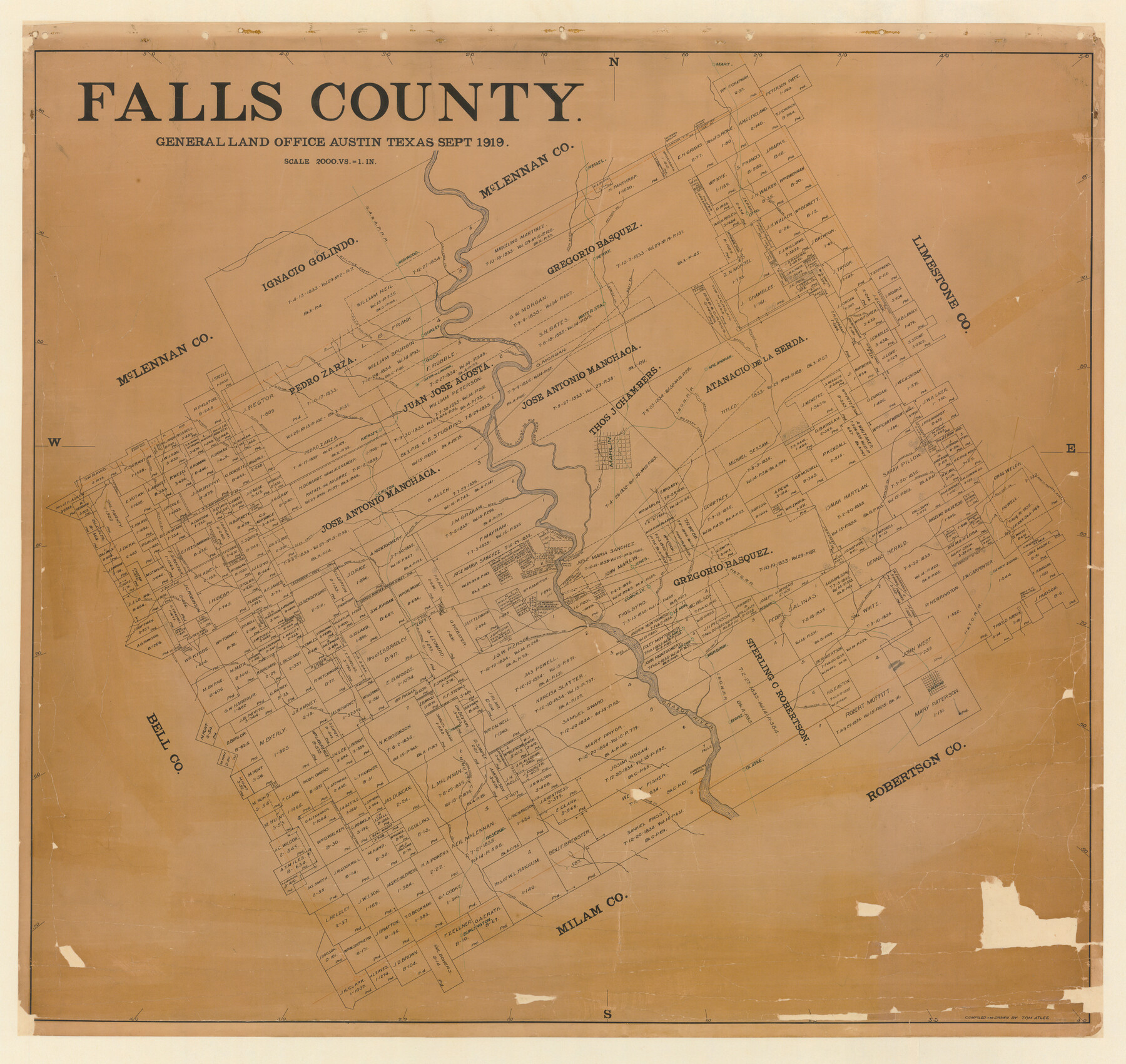
Falls County
-
Map/Doc
4714
-
Collection
General Map Collection
-
Object Dates
1919 (Creation Date)
-
People and Organizations
Texas General Land Office (Publisher)
Tom G. Atlee (Draftsman)
Tom G. Atlee (Compiler)
-
Counties
Falls
-
Subjects
County
-
Height x Width
42.2 x 44.7 inches
107.2 x 113.5 cm
-
Comments
Conservation funded in 2008 by Friends of the Texas General Land Office.
-
Features
Fish Creek
Pond Creek
Branch of Pond Creek
High Bank Creek
McCoy
High Bank
Eloise
Alligator Creek
Bremond
Middle Fork of Walnut Creek
Denny Siding
Little Brazos River
Travis
Reagan
H&TC
Isaacs Creek
Musclerun Creek
Clarks
Le Noir
Connally
Jones
Pierson Creek
Gleasons Creek
Laguna
Carothers Shoals
Blue Shoals
Head Waters of Pond Creek
Tehuacano Indian Village
Viesca
Old Town Tract of Milam
Smith's Falls
Deer Creek Branch of Deer Creek
East Fork of Sandy Creek
Sandy Creek
Lott
Walnut Creek
Eddy Road
Mooresville Road
Mill Prong of Little Deer Creek
Perry
Burlington
Olatke
Hog Creek
Rosebud
Goose Pond Creek
Cottonwood Creek
Kiersey
Satin
Guda
Gurley
Waco Golindo Road
West Prong of Cow Bayou
Cow Bayou
Lake Creek
Long Branch of Lake Creek
West Prong of Cottonwood Creek
Cow Creek
Mart
Big Creek
Otto
Peyton's Creek
Fish Bayou
Reisel
Brazos River
Castleman Creek
Norwood
SA&AP
Parkers Fort Road
South Deer Creek
Mooresville to Eddy Road
Hoolier Creek
Chilton
Deer Creek
Flat Creek
Pole Cat Creek
Wheelocks Creek
Harlin's Creek
Gibbon's Creek
Bullhide Creek
Rocky Creek
Brushy Creek
Keechi Creek
McLanahan
I&GN
Little Sandy Creek
Big Sandy Creek
Marlin
Old River Bed Creek
McCullough Slough
Part of: General Map Collection

Map of the Houston & Great Northern Railroad

Print $40.00
- Digital $50.00
Map of the Houston & Great Northern Railroad
1871
Size 26.6 x 48.4 inches
Map/Doc 64472
Flight Mission No. DCL-3C, Frame 156, Kenedy County

Print $20.00
- Digital $50.00
Flight Mission No. DCL-3C, Frame 156, Kenedy County
1943
Size 18.5 x 22.3 inches
Map/Doc 85804
Presidio County Rolled Sketch 78

Print $20.00
- Digital $50.00
Presidio County Rolled Sketch 78
1941
Size 32.4 x 39.2 inches
Map/Doc 7364
Culberson County Sketch File 15

Print $20.00
- Digital $50.00
Culberson County Sketch File 15
1933
Size 30.4 x 24.4 inches
Map/Doc 11267
Bell County Rolled Sketch 1

Print $20.00
- Digital $50.00
Bell County Rolled Sketch 1
1954
Size 39.7 x 43.2 inches
Map/Doc 8445
Randall County Sketch File 10

Print $4.00
- Digital $50.00
Randall County Sketch File 10
1941
Size 11.4 x 8.8 inches
Map/Doc 34972
Brazoria County NRC Article 33.136 Sketch 6

Print $22.00
- Digital $50.00
Brazoria County NRC Article 33.136 Sketch 6
2004
Size 24.6 x 35.2 inches
Map/Doc 82904
Live Oak County Working Sketch 31

Print $20.00
- Digital $50.00
Live Oak County Working Sketch 31
1991
Size 22.8 x 25.4 inches
Map/Doc 70616
Denton County Working Sketch 35

Print $20.00
- Digital $50.00
Denton County Working Sketch 35
2008
Size 24.7 x 19.3 inches
Map/Doc 88821
Medina County Working Sketch 19

Print $20.00
- Digital $50.00
Medina County Working Sketch 19
1980
Size 19.4 x 29.1 inches
Map/Doc 70934
Schleicher County Working Sketch 8

Print $20.00
- Digital $50.00
Schleicher County Working Sketch 8
1923
Size 21.6 x 18.6 inches
Map/Doc 63810
You may also like
Texas Boundary Line

Print $20.00
- Digital $50.00
Texas Boundary Line
Size 21.4 x 11.8 inches
Map/Doc 92076
[Beaumont, Sour Lake and Western Ry. Right of Way and Alignment - Frisco]
![64131, [Beaumont, Sour Lake and Western Ry. Right of Way and Alignment - Frisco], General Map Collection](https://historictexasmaps.com/wmedia_w700/maps/64131.tif.jpg)
Print $20.00
- Digital $50.00
[Beaumont, Sour Lake and Western Ry. Right of Way and Alignment - Frisco]
1910
Size 20.3 x 46.2 inches
Map/Doc 64131
Angelina County Sketch File 27

Print $10.00
- Digital $50.00
Angelina County Sketch File 27
1890
Size 14.1 x 8.7 inches
Map/Doc 13073
Hutchinson County Rolled Sketch 16

Print $20.00
- Digital $50.00
Hutchinson County Rolled Sketch 16
1912
Size 27.5 x 30.2 inches
Map/Doc 6284
United States - Gulf Coast Texas - Southern part of Laguna Madre

Print $20.00
- Digital $50.00
United States - Gulf Coast Texas - Southern part of Laguna Madre
1933
Size 26.9 x 18.3 inches
Map/Doc 72952
Flight Mission No. BRE-2P, Frame 38, Nueces County

Print $20.00
- Digital $50.00
Flight Mission No. BRE-2P, Frame 38, Nueces County
1956
Size 18.7 x 22.7 inches
Map/Doc 86740
Orange County Sketch File 4a

Print $22.00
- Digital $50.00
Orange County Sketch File 4a
1874
Size 16.0 x 13.0 inches
Map/Doc 33309
Galveston County NRC Article 33.136 Location Key Sheet

Print $20.00
- Digital $50.00
Galveston County NRC Article 33.136 Location Key Sheet
1994
Size 27.0 x 22.0 inches
Map/Doc 77020
Val Verde County Sketch File Z4

Print $8.00
- Digital $50.00
Val Verde County Sketch File Z4
1885
Size 14.3 x 8.9 inches
Map/Doc 39134

Johnson County

Print $20.00
- Digital $50.00
Johnson County
1943
Size 39.8 x 37.0 inches
Map/Doc 77332
Atascosa County Rolled Sketch 8

Print $20.00
- Digital $50.00
Atascosa County Rolled Sketch 8
1942
Size 34.8 x 41.9 inches
Map/Doc 8427