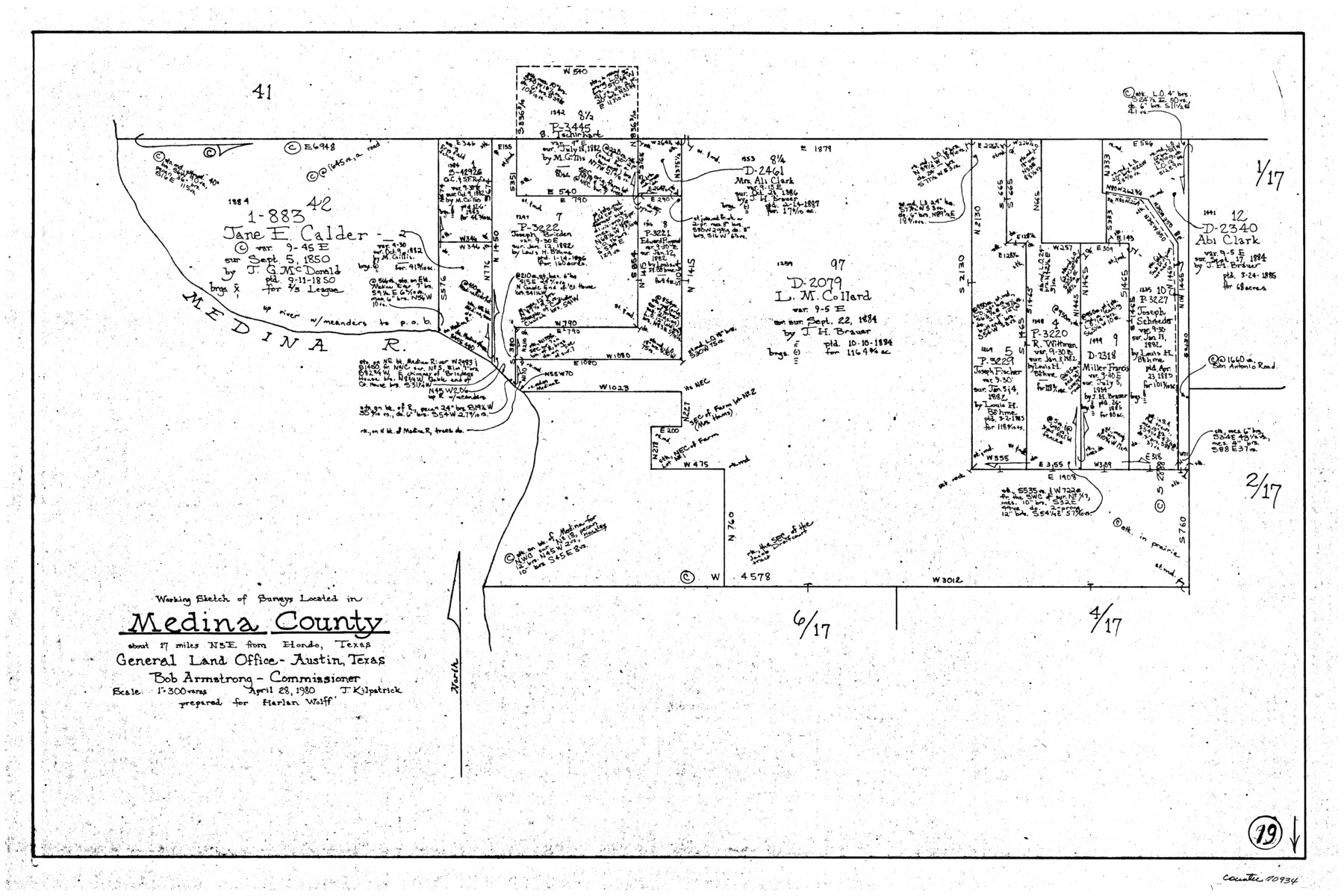
Medina County Working Sketch 19
-
Map/Doc
70934
-
Collection
General Map Collection
-
Object Dates
4/28/1980 (Creation Date)
-
People and Organizations
Joan Kilpatrick (Draftsman)
-
Counties
Medina
-
Subjects
Surveying Working Sketch
-
Height x Width
19.4 x 29.1 inches
49.3 x 73.9 cm
-
Scale
1" = 300 varas
Part of: General Map Collection
Montgomery County Working Sketch 10

Print $20.00
- Digital $50.00
Montgomery County Working Sketch 10
1933
Size 36.5 x 38.6 inches
Map/Doc 71117
Brewster County Working Sketch 18

Print $20.00
- Digital $50.00
Brewster County Working Sketch 18
1934
Size 35.9 x 37.8 inches
Map/Doc 67552
Zavala County Sketch File 48

Print $6.00
- Digital $50.00
Zavala County Sketch File 48
1942
Size 11.4 x 9.0 inches
Map/Doc 41438
Culberson County Rolled Sketch 39

Print $20.00
- Digital $50.00
Culberson County Rolled Sketch 39
Size 20.5 x 28.7 inches
Map/Doc 78465
Floyd County Working Sketch 5

Print $20.00
- Digital $50.00
Floyd County Working Sketch 5
1955
Size 33.3 x 23.6 inches
Map/Doc 69184
Bexar County Boundary File 2

Print $32.00
- Digital $50.00
Bexar County Boundary File 2
Size 8.4 x 4.0 inches
Map/Doc 50518
Montague County Working Sketch 15

Print $20.00
- Digital $50.00
Montague County Working Sketch 15
1943
Size 15.7 x 12.2 inches
Map/Doc 71081
Hudspeth County Working Sketch 40

Print $20.00
- Digital $50.00
Hudspeth County Working Sketch 40
1981
Size 35.6 x 43.8 inches
Map/Doc 66325

Motley County Boundary File 1a

Print $8.00
- Digital $50.00
Motley County Boundary File 1a
Size 11.2 x 8.5 inches
Map/Doc 57501
Austin County Sketch File 3

Print $40.00
- Digital $50.00
Austin County Sketch File 3
Size 17.1 x 13.6 inches
Map/Doc 10870
Field Notes of surveys in Hutchinson and Wheeler Counties

Field Notes of surveys in Hutchinson and Wheeler Counties
Map/Doc 81670
You may also like
Denton County Sketch File 42

Print $4.00
- Digital $50.00
Denton County Sketch File 42
1960
Size 11.4 x 8.9 inches
Map/Doc 20792
Waller County Sketch File 1a

Print $20.00
- Digital $50.00
Waller County Sketch File 1a
Size 25.4 x 16.6 inches
Map/Doc 12598
Louisiana and Texas Intracoastal Waterway

Print $20.00
- Digital $50.00
Louisiana and Texas Intracoastal Waterway
1929
Size 13.6 x 19.8 inches
Map/Doc 83345
Sutton County Sketch File A

Print $5.00
- Digital $50.00
Sutton County Sketch File A
Size 9.1 x 11.9 inches
Map/Doc 37389
Genl. Austins Map of Texas With Parts of the Adjoining States

Print $20.00
- Digital $50.00
Genl. Austins Map of Texas With Parts of the Adjoining States
1848
Size 30.4 x 25.1 inches
Map/Doc 94027
Chambers County Sketch File 40

Print $35.00
- Digital $50.00
Chambers County Sketch File 40
1925
Size 14.0 x 8.5 inches
Map/Doc 17677
The United States of America

Print $20.00
- Digital $50.00
The United States of America
1866
Size 22.4 x 18.2 inches
Map/Doc 72645
Sketch Showing surveys on Harbor Island in Nueces County

Print $20.00
- Digital $50.00
Sketch Showing surveys on Harbor Island in Nueces County
1951
Size 45.7 x 34.6 inches
Map/Doc 1915
Frio County Sketch File 13

Print $10.00
- Digital $50.00
Frio County Sketch File 13
1948
Size 11.3 x 8.8 inches
Map/Doc 23136
No. 2 Chart of Corpus Christi Pass, Texas

Print $20.00
- Digital $50.00
No. 2 Chart of Corpus Christi Pass, Texas
1878
Size 18.4 x 27.3 inches
Map/Doc 73016
Uvalde County Working Sketch 20

Print $20.00
- Digital $50.00
Uvalde County Working Sketch 20
1950
Size 41.5 x 32.4 inches
Map/Doc 72090
Presidio County Rolled Sketch 92

Print $20.00
- Digital $50.00
Presidio County Rolled Sketch 92
1947
Size 18.5 x 18.9 inches
Map/Doc 7377