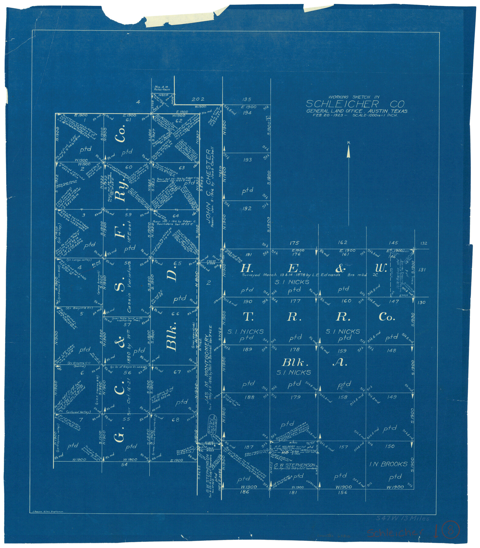
Schleicher County Working Sketch 8
-
Map/Doc
63810
-
Collection
General Map Collection
-
Object Dates
2/20/1923 (Creation Date)
-
People and Organizations
J. Bascom Giles (Draftsman)
-
Counties
Schleicher
-
Subjects
Surveying Working Sketch
-
Height x Width
21.6 x 18.6 inches
54.9 x 47.2 cm
-
Scale
1" = 1000 varas
Part of: General Map Collection
Uvalde County Working Sketch 30

Print $20.00
- Digital $50.00
Uvalde County Working Sketch 30
1962
Size 27.9 x 40.9 inches
Map/Doc 72100
Hutchinson County Rolled Sketch 44-17

Print $20.00
- Digital $50.00
Hutchinson County Rolled Sketch 44-17
2002
Size 24.0 x 36.0 inches
Map/Doc 77553
Flight Mission No. BRA-7M, Frame 151, Jefferson County

Print $20.00
- Digital $50.00
Flight Mission No. BRA-7M, Frame 151, Jefferson County
1953
Size 18.7 x 22.6 inches
Map/Doc 85545
Wheeler County Working Sketch 15

Print $20.00
- Digital $50.00
Wheeler County Working Sketch 15
1981
Size 27.9 x 29.3 inches
Map/Doc 72504
Hardin County Working Sketch 11

Print $20.00
- Digital $50.00
Hardin County Working Sketch 11
1929
Size 25.4 x 24.1 inches
Map/Doc 63409
Pecos County Rolled Sketch 82

Print $20.00
- Digital $50.00
Pecos County Rolled Sketch 82
1930
Size 28.3 x 25.8 inches
Map/Doc 10191
Old Miscellaneous File 6

Print $4.00
- Digital $50.00
Old Miscellaneous File 6
1847
Size 4.2 x 7.6 inches
Map/Doc 75420
Tom Green County Rolled Sketch 7

Print $20.00
- Digital $50.00
Tom Green County Rolled Sketch 7
Size 37.0 x 40.0 inches
Map/Doc 9998
Hansford County Sketch File 8

Print $6.00
- Digital $50.00
Hansford County Sketch File 8
1927
Size 11.3 x 8.7 inches
Map/Doc 24960
Polk County Rolled Sketch 32

Print $20.00
- Digital $50.00
Polk County Rolled Sketch 32
Size 21.6 x 15.8 inches
Map/Doc 7318
Harris County Working Sketch 73

Print $20.00
- Digital $50.00
Harris County Working Sketch 73
1959
Size 33.5 x 38.1 inches
Map/Doc 65965
Bosque County Working Sketch 33

Print $20.00
- Digital $50.00
Bosque County Working Sketch 33
2016
Size 37.0 x 25.0 inches
Map/Doc 93980
You may also like
West Part of Liberty Co.

Print $20.00
- Digital $50.00
West Part of Liberty Co.
1977
Size 43.5 x 32.9 inches
Map/Doc 77353
[Capitol Leagues 216-229]
![90705, [Capitol Leagues 216-229], Twichell Survey Records](https://historictexasmaps.com/wmedia_w700/maps/90705-1.tif.jpg)
Print $20.00
- Digital $50.00
[Capitol Leagues 216-229]
Size 25.2 x 26.7 inches
Map/Doc 90705
La Salle County Sketch File 7

Print $22.00
- Digital $50.00
La Salle County Sketch File 7
Size 8.0 x 12.3 inches
Map/Doc 29456
Sketch Showing Block 33, Township 5 North, T. & P. RR. Surveys

Print $20.00
- Digital $50.00
Sketch Showing Block 33, Township 5 North, T. & P. RR. Surveys
1921
Size 23.2 x 22.7 inches
Map/Doc 90635
La Salle County Sketch File 28a

Print $6.00
- Digital $50.00
La Salle County Sketch File 28a
1898
Size 4.5 x 5.2 inches
Map/Doc 29558
Sutton County Sketch File 50

Print $20.00
- Digital $50.00
Sutton County Sketch File 50
1941
Size 18.6 x 18.4 inches
Map/Doc 12392
Walker County

Print $20.00
- Digital $50.00
Walker County
1944
Size 44.8 x 38.5 inches
Map/Doc 63106
Shores of Laguna Madre, Texas from Triangulation Station Griffins to Triangulation Station Camp No. 2

Print $40.00
- Digital $50.00
Shores of Laguna Madre, Texas from Triangulation Station Griffins to Triangulation Station Camp No. 2
1882
Size 33.2 x 54.3 inches
Map/Doc 73483
Burnet County Rolled Sketch T

Print $20.00
- Digital $50.00
Burnet County Rolled Sketch T
Size 24.7 x 18.3 inches
Map/Doc 5359
Stonewall County Rolled Sketch 17

Print $20.00
- Digital $50.00
Stonewall County Rolled Sketch 17
1927
Size 20.1 x 30.2 inches
Map/Doc 7871
Galveston County Sketch File 60

Print $103.00
- Digital $50.00
Galveston County Sketch File 60
1988
Size 14.3 x 8.8 inches
Map/Doc 23611
Pecos County Sketch File 29a

Print $20.00
- Digital $50.00
Pecos County Sketch File 29a
Size 24.5 x 31.0 inches
Map/Doc 12171