Hansford County Sketch File 8
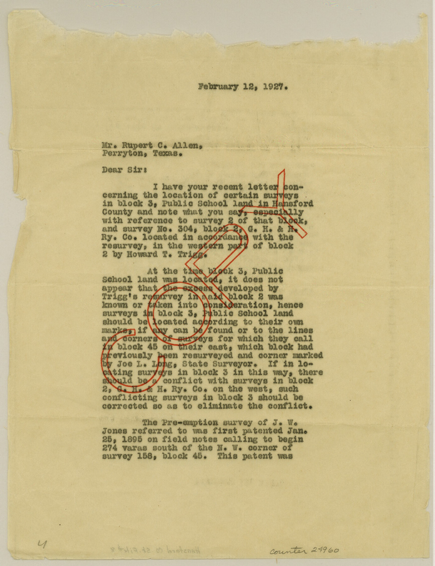
[Letter of instruction to Rupert C. Allen as to proper way of correcting surveys]
-
Map/Doc
24960
-
Collection
General Map Collection
-
Object Dates
1927/2/12 (Creation Date)
1922/2/2 (Survey Date)
1917/12/10 (Survey Date)
-
People and Organizations
Blucher (Surveyor/Engineer)
Howard T. Trigg (Surveyor/Engineer)
Joe L. Long (Surveyor/Engineer)
-
Counties
Hansford
-
Subjects
Surveying Sketch File
-
Height x Width
11.3 x 8.7 inches
28.7 x 22.1 cm
-
Medium
paper, print
Part of: General Map Collection
Matagorda County Sketch File 43

Print $20.00
- Digital $50.00
Matagorda County Sketch File 43
1839
Size 13.2 x 8.2 inches
Map/Doc 30868
Erath County Sketch File 8a

Print $6.00
- Digital $50.00
Erath County Sketch File 8a
1853
Size 15.9 x 11.0 inches
Map/Doc 22271
Nueces County Rolled Sketch 73

Print $20.00
- Digital $50.00
Nueces County Rolled Sketch 73
1981
Size 24.2 x 36.0 inches
Map/Doc 6931
Colonial Texas. 1822 to 1834.

Print $20.00
- Digital $50.00
Colonial Texas. 1822 to 1834.
1897
Size 12.8 x 16.3 inches
Map/Doc 93410
Duval County Sketch File 31

Print $20.00
- Digital $50.00
Duval County Sketch File 31
1932
Size 29.3 x 17.7 inches
Map/Doc 11389
[Sketch for Mineral Application 24072, San Jacinto River]
![65594, [Sketch for Mineral Application 24072, San Jacinto River], General Map Collection](https://historictexasmaps.com/wmedia_w700/maps/65594.tif.jpg)
Print $20.00
- Digital $50.00
[Sketch for Mineral Application 24072, San Jacinto River]
1929
Size 25.8 x 20.8 inches
Map/Doc 65594
Laguna Madre, T-9210

Print $20.00
- Digital $50.00
Laguna Madre, T-9210
Size 34.6 x 31.9 inches
Map/Doc 73601
King County Working Sketch 8

Print $20.00
- Digital $50.00
King County Working Sketch 8
1955
Size 30.8 x 24.8 inches
Map/Doc 70172
Maps of Gulf Intracoastal Waterway, Texas - Sabine River to the Rio Grande and connecting waterways including ship channels

Print $20.00
- Digital $50.00
Maps of Gulf Intracoastal Waterway, Texas - Sabine River to the Rio Grande and connecting waterways including ship channels
1966
Size 14.6 x 22.2 inches
Map/Doc 61946
Tarrant County Working Sketch 26

Print $20.00
- Digital $50.00
Tarrant County Working Sketch 26
2004
Size 27.1 x 43.9 inches
Map/Doc 83586
Fractional Township No. 7 South Range No. 15 East of the Indian Meridian, Indian Territory

Print $20.00
- Digital $50.00
Fractional Township No. 7 South Range No. 15 East of the Indian Meridian, Indian Territory
1896
Size 19.2 x 24.3 inches
Map/Doc 75226
Brewster County Working Sketch 14

Print $20.00
- Digital $50.00
Brewster County Working Sketch 14
1929
Size 21.3 x 22.7 inches
Map/Doc 67547
You may also like
Lynn County Sketch File 20

Print $4.00
- Digital $50.00
Lynn County Sketch File 20
1891
Size 8.8 x 10.9 inches
Map/Doc 30527
Nacogdoches County Working Sketch Graphic Index

Print $20.00
- Digital $50.00
Nacogdoches County Working Sketch Graphic Index
1950
Size 46.9 x 41.3 inches
Map/Doc 76651
Reagan County Sketch File 14

Print $6.00
- Digital $50.00
Reagan County Sketch File 14
Size 11.3 x 8.8 inches
Map/Doc 34993
Flight Mission No. CUG-1P, Frame 103, Kleberg County

Print $20.00
- Digital $50.00
Flight Mission No. CUG-1P, Frame 103, Kleberg County
1956
Size 18.5 x 22.6 inches
Map/Doc 86153
Gillespie County

Print $40.00
- Digital $50.00
Gillespie County
1887
Size 34.6 x 49.8 inches
Map/Doc 66836
Palo Pinto County Rolled Sketch 4

Print $20.00
- Digital $50.00
Palo Pinto County Rolled Sketch 4
Size 15.9 x 23.2 inches
Map/Doc 7189
Coke County Rolled Sketch 13

Print $40.00
- Digital $50.00
Coke County Rolled Sketch 13
Size 44.5 x 69.9 inches
Map/Doc 8627
Current Miscellaneous File 99

Print $32.00
- Digital $50.00
Current Miscellaneous File 99
1984
Size 11.2 x 8.7 inches
Map/Doc 74340
Pecos County Sketch File 46

Print $26.00
- Digital $50.00
Pecos County Sketch File 46
1921
Size 11.4 x 8.9 inches
Map/Doc 33746
Presidio County Rolled Sketch 116

Print $20.00
- Digital $50.00
Presidio County Rolled Sketch 116
1981
Size 30.9 x 25.0 inches
Map/Doc 9795
Rio Grande Rectification Project, El Paso and Juarez Valley

Print $20.00
- Digital $50.00
Rio Grande Rectification Project, El Paso and Juarez Valley
1935
Size 10.7 x 29.6 inches
Map/Doc 60866
Andrews County Rolled Sketch 11

Print $20.00
- Digital $50.00
Andrews County Rolled Sketch 11
1933
Size 28.0 x 37.7 inches
Map/Doc 77161