Matagorda County Sketch File 43
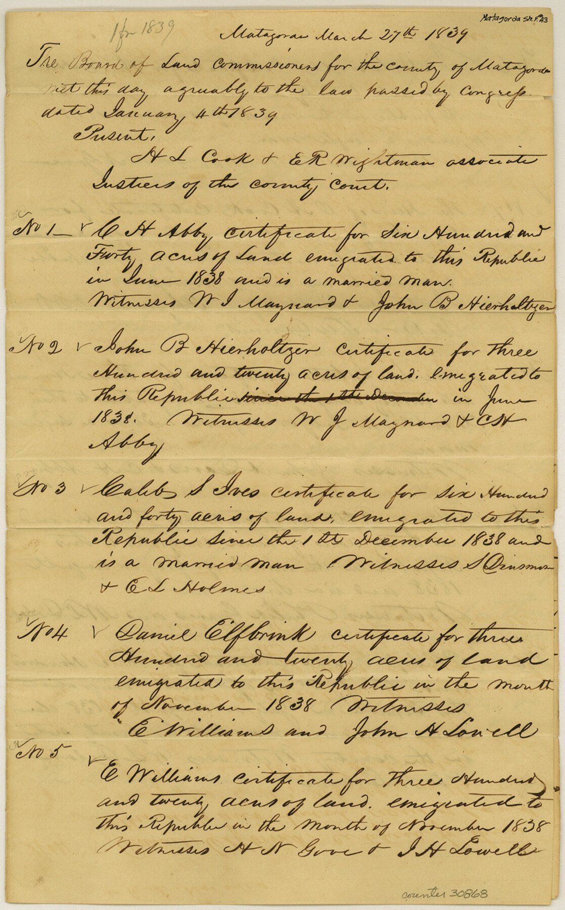
[Copy of clerk returns of the Board of Land Commissioners showing 1st, 2nd and 3rd Class certificates issued up to 30th April, 1839]
-
Map/Doc
30868
-
Collection
General Map Collection
-
Object Dates
4/30/1839 (Creation Date)
10/8/1986 (File Date)
3/27/1839 (Creation Date)
-
Counties
Matagorda
-
Subjects
Surveying Sketch File
-
Height x Width
13.2 x 8.2 inches
33.5 x 20.8 cm
-
Medium
paper, manuscript
Part of: General Map Collection
Collin County Boundary File 18 and 18a

Print $8.00
- Digital $50.00
Collin County Boundary File 18 and 18a
Size 7.8 x 4.0 inches
Map/Doc 51717
Motley County

Print $20.00
- Digital $50.00
Motley County
1914
Size 47.0 x 37.7 inches
Map/Doc 66946
Township No. 6 South Range No. 9 West of the Indian Meridian

Print $20.00
- Digital $50.00
Township No. 6 South Range No. 9 West of the Indian Meridian
1874
Size 19.2 x 24.5 inches
Map/Doc 75166
Wheeler County

Print $20.00
- Digital $50.00
Wheeler County
1878
Size 18.5 x 16.6 inches
Map/Doc 4140
Hudspeth County Working Sketch 54

Print $20.00
- Digital $50.00
Hudspeth County Working Sketch 54
1989
Size 18.8 x 36.2 inches
Map/Doc 66339
Glasscock County Sketch File 19

Print $20.00
- Digital $50.00
Glasscock County Sketch File 19
Size 21.4 x 16.8 inches
Map/Doc 11563
Trinity River, Mountain Creek Sheet

Print $40.00
- Digital $50.00
Trinity River, Mountain Creek Sheet
1918
Size 51.3 x 34.7 inches
Map/Doc 65211
Harris County Rolled Sketch 33

Print $20.00
- Digital $50.00
Harris County Rolled Sketch 33
1912
Size 26.0 x 34.5 inches
Map/Doc 6097
Schleicher County Rolled Sketch 21

Print $20.00
- Digital $50.00
Schleicher County Rolled Sketch 21
1959
Size 47.4 x 31.5 inches
Map/Doc 9907
Sutton County Rolled Sketch 56

Print $20.00
- Digital $50.00
Sutton County Rolled Sketch 56
Size 23.6 x 28.0 inches
Map/Doc 7895
Montgomery County Working Sketch 15

Print $40.00
- Digital $50.00
Montgomery County Working Sketch 15
1934
Size 51.8 x 41.6 inches
Map/Doc 71122
Atascosa County Sketch File 4

Print $7.00
- Digital $50.00
Atascosa County Sketch File 4
1854
Size 8.1 x 6.5 inches
Map/Doc 13745
You may also like
Carson County Sketch File 1

Print $20.00
- Digital $50.00
Carson County Sketch File 1
Size 16.8 x 18.5 inches
Map/Doc 11053
Sabine County Working Sketch Graphic Index

Print $20.00
- Digital $50.00
Sabine County Working Sketch Graphic Index
1920
Size 42.4 x 33.1 inches
Map/Doc 76689
Brooks County Working Sketch 12

Print $20.00
- Digital $50.00
Brooks County Working Sketch 12
1943
Size 27.0 x 26.5 inches
Map/Doc 67796
Castro County Working Sketch 1

Print $20.00
- Digital $50.00
Castro County Working Sketch 1
Size 22.8 x 17.7 inches
Map/Doc 67896
Lubbock County Rolled Sketch 7

Print $20.00
- Digital $50.00
Lubbock County Rolled Sketch 7
1944
Size 25.8 x 32.9 inches
Map/Doc 6643
Pecos County Sketch File 73

Print $48.00
- Digital $50.00
Pecos County Sketch File 73
1940
Size 8.9 x 9.1 inches
Map/Doc 33876
Concho County Sketch File 3

Print $6.00
- Digital $50.00
Concho County Sketch File 3
1857
Size 13.1 x 8.4 inches
Map/Doc 19124
University Land Field Notes for Blocks 46 and 48 in Culberson County

University Land Field Notes for Blocks 46 and 48 in Culberson County
Map/Doc 81721

Map of Zapata County

Print $40.00
- Digital $50.00
Map of Zapata County
1901
Size 55.1 x 47.7 inches
Map/Doc 16937
Lavaca County Rolled Sketch 3

Print $20.00
- Digital $50.00
Lavaca County Rolled Sketch 3
1959
Size 42.8 x 32.8 inches
Map/Doc 9419
Tom Green County Sketch File 5

Print $42.00
- Digital $50.00
Tom Green County Sketch File 5
1849
Size 8.5 x 7.1 inches
Map/Doc 38167