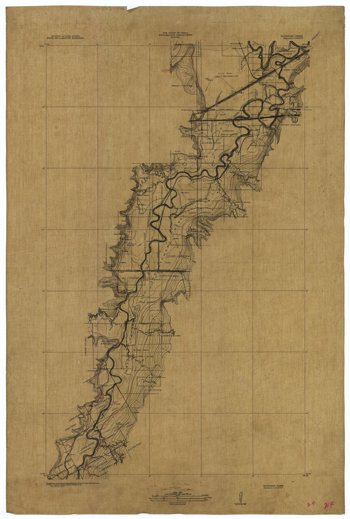
Trinity River, Mountain Creek Sheet
-
Map/Doc
65211
-
Collection
General Map Collection
-
Object Dates
1918 (Creation Date)
-
People and Organizations
Texas State Reclamation Department (Publisher)
Dixon B. Penick (Surveyor/Engineer)
J.B. Upchurch (Surveyor/Engineer)
-
Counties
Dallas
-
Subjects
River Surveys Topographic
-
Height x Width
51.3 x 34.7 inches
130.3 x 88.1 cm
-
Comments
Mountain Creek Sheet located southwest of the Eagle Ford Sheet and south of the Irving Sheet.
Part of: General Map Collection
Kaufman County Sketch File 12

Print $4.00
- Digital $50.00
Kaufman County Sketch File 12
1862
Size 12.9 x 8.2 inches
Map/Doc 28647
Menard County Sketch File 5

Print $20.00
- Digital $50.00
Menard County Sketch File 5
Size 5.6 x 43.3 inches
Map/Doc 10542
Harris County Rolled Sketch 93

Print $20.00
- Digital $50.00
Harris County Rolled Sketch 93
1983
Size 45.0 x 40.2 inches
Map/Doc 9142
Johnson County

Print $20.00
- Digital $50.00
Johnson County
1943
Size 43.3 x 40.2 inches
Map/Doc 95549
Bell County Working Sketch 12

Print $20.00
- Digital $50.00
Bell County Working Sketch 12
1956
Size 17.2 x 22.0 inches
Map/Doc 67352
Baylor County Working Sketch 4

Print $20.00
- Digital $50.00
Baylor County Working Sketch 4
1938
Size 30.4 x 21.0 inches
Map/Doc 67289
Fort Bend County Working Sketch 10

Print $20.00
- Digital $50.00
Fort Bend County Working Sketch 10
1934
Size 30.6 x 20.2 inches
Map/Doc 69216
Edwards County Working Sketch 37

Print $20.00
- Digital $50.00
Edwards County Working Sketch 37
1948
Size 23.1 x 35.5 inches
Map/Doc 68913
Liberty County Working Sketch 2

Print $20.00
- Digital $50.00
Liberty County Working Sketch 2
Size 12.4 x 22.2 inches
Map/Doc 70461
Lamb County Sketch File 2

Print $40.00
- Digital $50.00
Lamb County Sketch File 2
1888
Size 17.1 x 14.4 inches
Map/Doc 29342
Aransas County Aerial Photograph Index Sheet 2

Print $20.00
- Digital $50.00
Aransas County Aerial Photograph Index Sheet 2
1957
Size 23.0 x 17.9 inches
Map/Doc 83660
Military Reconnaissance [showing forts along Rio Grande near Matamoros]
![72911, Military Reconnaissance [showing forts along Rio Grande near Matamoros], General Map Collection](https://historictexasmaps.com/wmedia_w700/maps/72911.tif.jpg)
Print $20.00
- Digital $50.00
Military Reconnaissance [showing forts along Rio Grande near Matamoros]
1846
Size 18.2 x 27.2 inches
Map/Doc 72911
You may also like
Val Verde County Sketch File XXX

Print $30.00
- Digital $50.00
Val Verde County Sketch File XXX
1908
Size 39.2 x 24.6 inches
Map/Doc 10424
Proposed bombing and machine gun restricted areas along Gulf of Mexico from San Luis Pass to Aransas Pass

Print $20.00
- Digital $50.00
Proposed bombing and machine gun restricted areas along Gulf of Mexico from San Luis Pass to Aransas Pass
1941
Size 11.1 x 24.1 inches
Map/Doc 3024
Brazoria County Sketch File 16

Print $16.00
- Digital $50.00
Brazoria County Sketch File 16
1893
Size 9.4 x 4.3 inches
Map/Doc 14981
Surveys in Austin's Colony along the east fork of Mill Creek

Print $20.00
- Digital $50.00
Surveys in Austin's Colony along the east fork of Mill Creek
1830
Size 23.7 x 12.6 inches
Map/Doc 208
Flight Mission No. DAH-17M, Frame 22, Orange County

Print $20.00
- Digital $50.00
Flight Mission No. DAH-17M, Frame 22, Orange County
1953
Size 18.8 x 22.6 inches
Map/Doc 86885
Jones County Sketch File 10

Print $20.00
- Digital $50.00
Jones County Sketch File 10
1875
Size 14.3 x 22.2 inches
Map/Doc 11900
Zapata County Working Sketch 22

Print $20.00
- Digital $50.00
Zapata County Working Sketch 22
1984
Size 31.8 x 40.1 inches
Map/Doc 62073
Hopkins County

Print $20.00
- Digital $50.00
Hopkins County
1888
Size 36.4 x 36.6 inches
Map/Doc 448
Williamson County Sketch File 21

Print $4.00
- Digital $50.00
Williamson County Sketch File 21
1893
Size 11.3 x 8.7 inches
Map/Doc 40350
Panola County Rolled Sketch 5

Print $40.00
- Digital $50.00
Panola County Rolled Sketch 5
Size 81.0 x 33.1 inches
Map/Doc 9678
Fannin County Boundary File 9

Print $14.00
- Digital $50.00
Fannin County Boundary File 9
Size 13.2 x 8.8 inches
Map/Doc 53318
Shelby County Working Sketch 12

Print $40.00
- Digital $50.00
Shelby County Working Sketch 12
1946
Size 53.4 x 36.4 inches
Map/Doc 63865