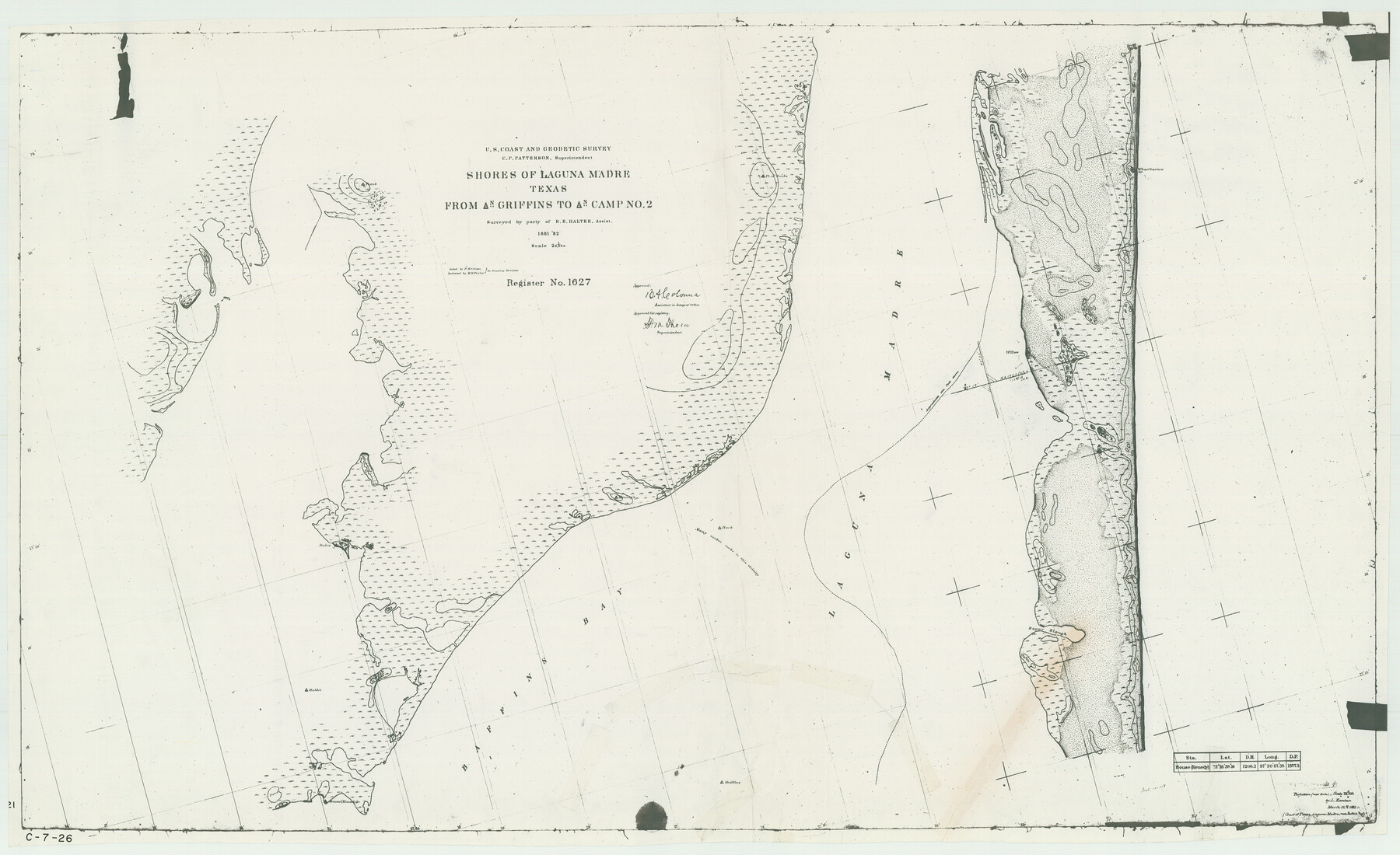
Shores of Laguna Madre, Texas from Triangulation Station Griffins to Triangulation Station Camp No. 2
C-7-26
-
Map/Doc
73483
-
Collection
General Map Collection
-
Object Dates
1882 (Creation Date)
-
Counties
Nueces Kleberg
-
Subjects
Nautical Charts
-
Height x Width
33.2 x 54.3 inches
84.3 x 137.9 cm
-
Comments
Register No. 1627
Part of: General Map Collection
Brewster County Working Sketch 30

Print $40.00
- Digital $50.00
Brewster County Working Sketch 30
1942
Size 44.6 x 59.6 inches
Map/Doc 67564
Medina County Working Sketch 7

Print $20.00
- Digital $50.00
Medina County Working Sketch 7
1952
Size 26.3 x 28.5 inches
Map/Doc 70922

Flight Mission No. CRC-3R, Frame 16, Chambers County

Print $20.00
- Digital $50.00
Flight Mission No. CRC-3R, Frame 16, Chambers County
1956
Size 18.6 x 22.2 inches
Map/Doc 84790
Township No. 4 South Range No. 15 West of the Indian Meridian

Print $4.00
- Digital $50.00
Township No. 4 South Range No. 15 West of the Indian Meridian
1875
Size 17.9 x 22.4 inches
Map/Doc 75151
Orange County Sketch File 42

Print $40.00
- Digital $50.00
Orange County Sketch File 42
1873
Size 12.8 x 15.8 inches
Map/Doc 33383
Map of Rains County

Print $20.00
- Digital $50.00
Map of Rains County
1873
Size 12.5 x 11.6 inches
Map/Doc 4618
Jeff Davis County Working Sketch 23

Print $20.00
- Digital $50.00
Jeff Davis County Working Sketch 23
1958
Size 41.5 x 30.7 inches
Map/Doc 66518
Lavaca County Working Sketch 11

Print $20.00
- Digital $50.00
Lavaca County Working Sketch 11
1954
Size 34.0 x 28.3 inches
Map/Doc 70364
Bastrop County

Print $20.00
- Digital $50.00
Bastrop County
1879
Size 21.5 x 19.5 inches
Map/Doc 3277
Flight Mission No. DCL-7C, Frame 37, Kenedy County

Print $20.00
- Digital $50.00
Flight Mission No. DCL-7C, Frame 37, Kenedy County
1943
Size 15.4 x 15.3 inches
Map/Doc 86025
Duval County Sketch File 32a

Print $20.00
- Digital $50.00
Duval County Sketch File 32a
1932
Size 16.2 x 14.2 inches
Map/Doc 11390
You may also like
[Sketch of Surveys in Crockett County, Texas]
![10778, [Sketch of Surveys in Crockett County, Texas], Maddox Collection](https://historictexasmaps.com/wmedia_w700/maps/10778.tif.jpg)
Print $20.00
- Digital $50.00
[Sketch of Surveys in Crockett County, Texas]
1880
Size 12.7 x 21.3 inches
Map/Doc 10778
Hardeman County Sketch File 15

Print $20.00
- Digital $50.00
Hardeman County Sketch File 15
Size 18.9 x 17.9 inches
Map/Doc 11627
Wharton County Rolled Sketch 13

Print $20.00
- Digital $50.00
Wharton County Rolled Sketch 13
1990
Size 22.4 x 28.1 inches
Map/Doc 8238
El Paso County Boundary File 6

Print $14.00
- Digital $50.00
El Paso County Boundary File 6
Size 14.0 x 8.8 inches
Map/Doc 53080
[Blocks Z3, K5, 8, and 7]
![90590, [Blocks Z3, K5, 8, and 7], Twichell Survey Records](https://historictexasmaps.com/wmedia_w700/maps/90590-1.tif.jpg)
Print $20.00
- Digital $50.00
[Blocks Z3, K5, 8, and 7]
Size 11.7 x 19.3 inches
Map/Doc 90590
Sterling County Sketch File 6

Print $12.00
- Digital $50.00
Sterling County Sketch File 6
1912
Size 5.7 x 8.8 inches
Map/Doc 37115
Hamilton County Working Sketch 25

Print $20.00
- Digital $50.00
Hamilton County Working Sketch 25
1963
Size 29.5 x 26.6 inches
Map/Doc 63363

Hopkins County Sketch File 1

Print $4.00
- Digital $50.00
Hopkins County Sketch File 1
1854
Size 5.2 x 10.2 inches
Map/Doc 26676
Flight Mission No. DAG-18K, Frame 69, Matagorda County

Print $20.00
- Digital $50.00
Flight Mission No. DAG-18K, Frame 69, Matagorda County
1952
Size 16.3 x 16.2 inches
Map/Doc 86362
Johnson County Working Sketch 4

Print $20.00
- Digital $50.00
Johnson County Working Sketch 4
1948
Size 26.5 x 24.6 inches
Map/Doc 66617
Levelland, Hockley County, Texas

Print $20.00
- Digital $50.00
Levelland, Hockley County, Texas
1950
Size 13.1 x 14.9 inches
Map/Doc 92241