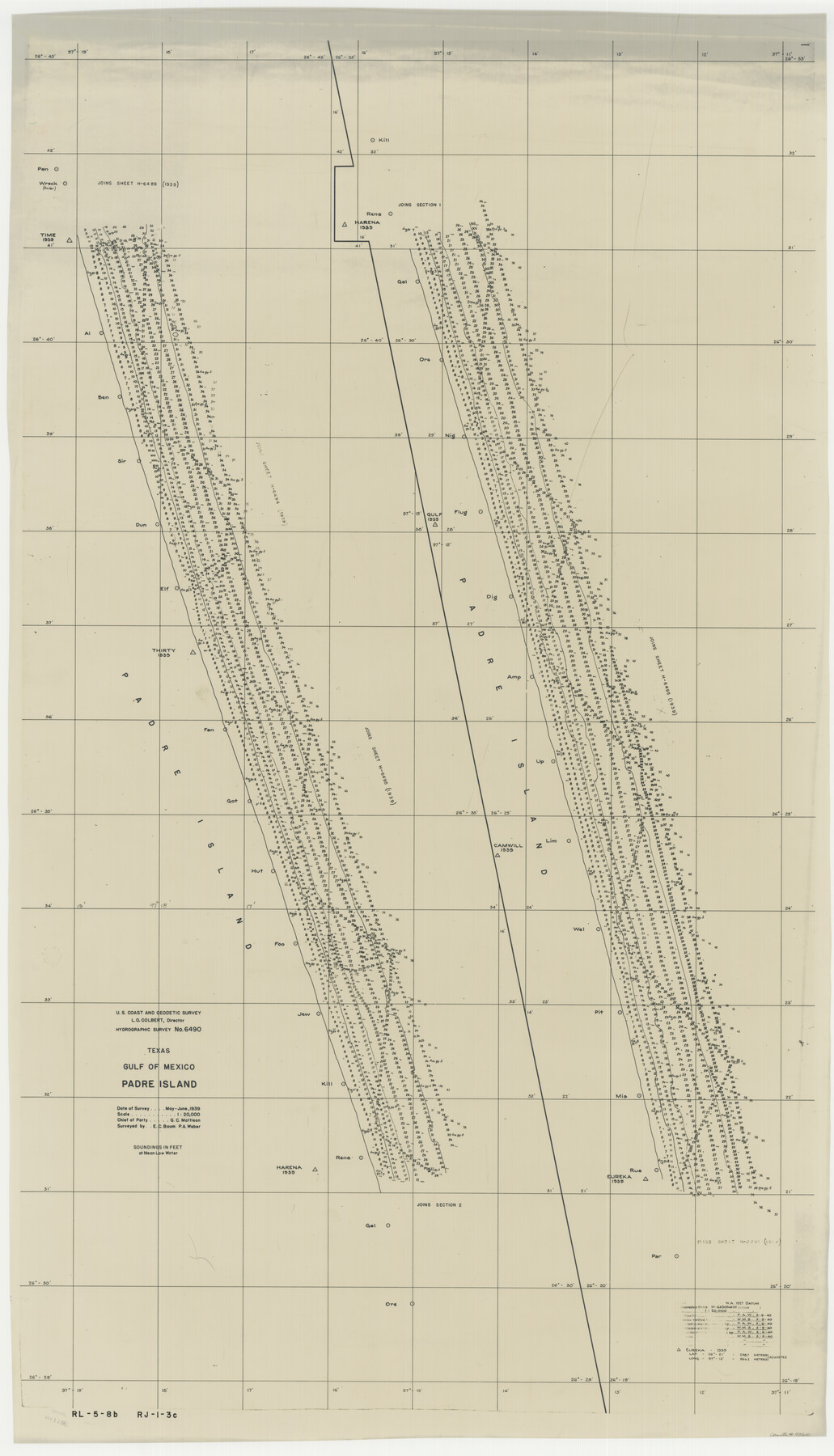
Padre Island
Gulf of Mexico
-
Map/Doc
73610
-
Collection
General Map Collection
-
Height x Width
64.2 x 36.7 inches
163.1 x 93.2 cm
-
Medium
mylar
Part of: General Map Collection
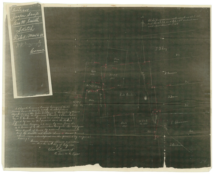
Cherokee County Sketch File 16

Print $44.00
- Digital $50.00
Cherokee County Sketch File 16
1862
Size 10.0 x 8.0 inches
Map/Doc 18152
Liberty County Working Sketch 35

Print $20.00
- Digital $50.00
Liberty County Working Sketch 35
1948
Size 22.3 x 42.3 inches
Map/Doc 70494
Brewster County Working Sketch 52

Print $20.00
- Digital $50.00
Brewster County Working Sketch 52
1951
Size 28.7 x 37.3 inches
Map/Doc 67586

Wheeler County

Print $20.00
- Digital $50.00
Wheeler County
1899
Size 42.2 x 37.9 inches
Map/Doc 95672
Calhoun County Rolled Sketch 30

Print $20.00
- Digital $50.00
Calhoun County Rolled Sketch 30
1974
Size 18.8 x 27.6 inches
Map/Doc 5494
Flight Mission No. BRE-2P, Frame 103, Nueces County

Print $20.00
- Digital $50.00
Flight Mission No. BRE-2P, Frame 103, Nueces County
1956
Size 18.5 x 22.2 inches
Map/Doc 86788
Jasper County Working Sketch 25

Print $20.00
- Digital $50.00
Jasper County Working Sketch 25
1951
Size 21.6 x 32.3 inches
Map/Doc 66487
Newton County Rolled Sketch 24
Print $20.00
- Digital $50.00
Newton County Rolled Sketch 24
1893
Size 18.8 x 20.8 inches
Map/Doc 6851
Austin's colony 1821-1836: In commemoration of the two hundredth birthday of Stephen F. Austin

Print $20.00
- Digital $50.00
Austin's colony 1821-1836: In commemoration of the two hundredth birthday of Stephen F. Austin
1993
Size 24.6 x 34.5 inches
Map/Doc 1675

Flight Mission No. DQO-8K, Frame 69, Galveston County

Print $20.00
- Digital $50.00
Flight Mission No. DQO-8K, Frame 69, Galveston County
1952
Size 18.8 x 22.5 inches
Map/Doc 85173
You may also like
[Surveys along the Lavaca River]
![25, [Surveys along the Lavaca River], General Map Collection](https://historictexasmaps.com/wmedia_w700/maps/25.tif.jpg)
Print $2.00
- Digital $50.00
[Surveys along the Lavaca River]
1833
Size 12.9 x 8.9 inches
Map/Doc 25
Houston Ship Channel, Atkinson Island to Alexander Island

Print $40.00
- Digital $50.00
Houston Ship Channel, Atkinson Island to Alexander Island
1973
Size 36.7 x 50.2 inches
Map/Doc 69902
Roberts County Rolled Sketch 1

Print $20.00
- Digital $50.00
Roberts County Rolled Sketch 1
Size 18.4 x 23.5 inches
Map/Doc 7510
Mason County Sketch File 21A

Print $20.00
- Digital $50.00
Mason County Sketch File 21A
1932
Size 19.2 x 26.6 inches
Map/Doc 12037
The Republic County of Harrison. January 16, 1843

Print $20.00
The Republic County of Harrison. January 16, 1843
2020
Size 18.6 x 21.7 inches
Map/Doc 96174
El Paso County Rolled Sketch 64

Print $246.00
- Digital $50.00
El Paso County Rolled Sketch 64
1993
Size 11.3 x 8.7 inches
Map/Doc 41531
Gaines County Working Sketch Graphic Index

Print $40.00
- Digital $50.00
Gaines County Working Sketch Graphic Index
1956
Size 42.7 x 54.0 inches
Map/Doc 76550
Map of Parker County

Print $20.00
- Digital $50.00
Map of Parker County
1879
Size 23.9 x 19.0 inches
Map/Doc 3947
King County Working Sketch 16

Print $40.00
- Digital $50.00
King County Working Sketch 16
1979
Size 41.4 x 59.4 inches
Map/Doc 70180
General Highway Map. Detail of Cities and Towns in Bastrop County, Texas [Bastrop, Smithville, Elgin, etc.]
![79362, General Highway Map. Detail of Cities and Towns in Bastrop County, Texas [Bastrop, Smithville, Elgin, etc.], Texas State Library and Archives](https://historictexasmaps.com/wmedia_w700/maps/79362.tif.jpg)
Print $20.00
General Highway Map. Detail of Cities and Towns in Bastrop County, Texas [Bastrop, Smithville, Elgin, etc.]
1961
Size 18.3 x 25.0 inches
Map/Doc 79362
Loving County Working Sketch 23

Print $20.00
- Digital $50.00
Loving County Working Sketch 23
1952
Size 15.1 x 31.5 inches
Map/Doc 70657
Flight Mission No. BRE-1P, Frame 67, Nueces County

Print $20.00
- Digital $50.00
Flight Mission No. BRE-1P, Frame 67, Nueces County
1956
Size 18.7 x 22.4 inches
Map/Doc 86649