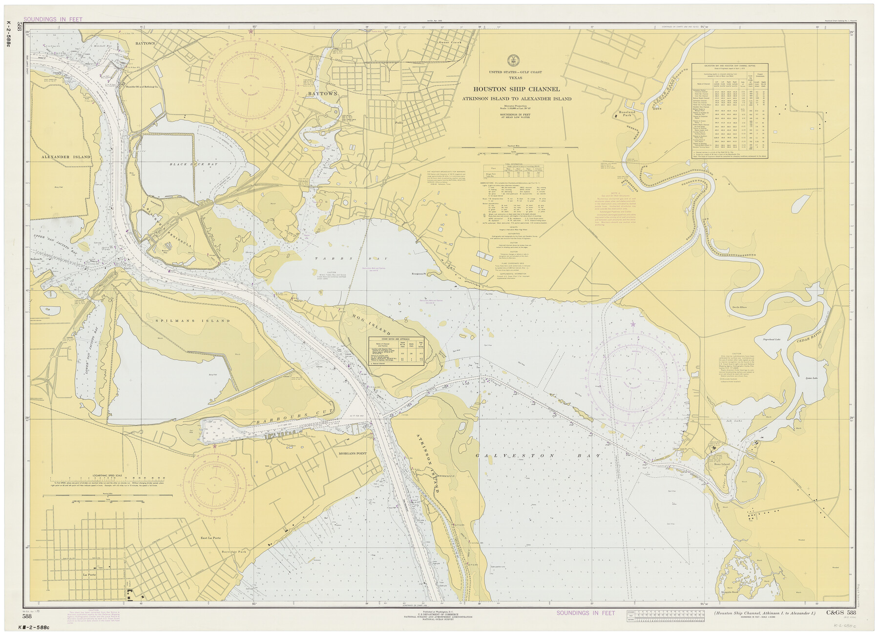
Houston Ship Channel, Atkinson Island to Alexander Island
K-2-588a
-
Map/Doc
69902
-
Collection
General Map Collection
-
Object Dates
4/7/1973 (Creation Date)
-
Counties
Harris Chambers
-
Subjects
Nautical Charts
-
Height x Width
36.7 x 50.2 inches
93.2 x 127.5 cm
Part of: General Map Collection
Tarrant County Sketch File 3

Print $4.00
- Digital $50.00
Tarrant County Sketch File 3
Size 11.8 x 8.2 inches
Map/Doc 37676
Matagorda County Sketch File 17

Print $20.00
- Digital $50.00
Matagorda County Sketch File 17
1877
Size 16.4 x 14.5 inches
Map/Doc 12040
Harrison County Rolled Sketch 15

Print $20.00
- Digital $50.00
Harrison County Rolled Sketch 15
2008
Size 20.5 x 21.0 inches
Map/Doc 89045
Fractional Township No. 9 South Range No. 9 East of the Indian Meridian, Indian Territory

Print $20.00
- Digital $50.00
Fractional Township No. 9 South Range No. 9 East of the Indian Meridian, Indian Territory
1898
Size 19.2 x 24.4 inches
Map/Doc 75216
Flight Mission No. DQN-2K, Frame 71, Calhoun County

Print $20.00
- Digital $50.00
Flight Mission No. DQN-2K, Frame 71, Calhoun County
1953
Size 18.9 x 22.4 inches
Map/Doc 84263
Zapata County Sketch File 7

Print $70.00
- Digital $50.00
Zapata County Sketch File 7
1918
Size 14.4 x 8.8 inches
Map/Doc 40911
Flight Mission No. DIX-5P, Frame 149, Aransas County

Print $20.00
- Digital $50.00
Flight Mission No. DIX-5P, Frame 149, Aransas County
1956
Size 17.8 x 17.8 inches
Map/Doc 83811
Culberson County Working Sketch 58

Print $20.00
- Digital $50.00
Culberson County Working Sketch 58
1974
Size 45.2 x 35.1 inches
Map/Doc 68512
Maps of Block 97, Borden & Scurry Counties

Print $40.00
- Digital $50.00
Maps of Block 97, Borden & Scurry Counties
Size 58.2 x 42.2 inches
Map/Doc 65691
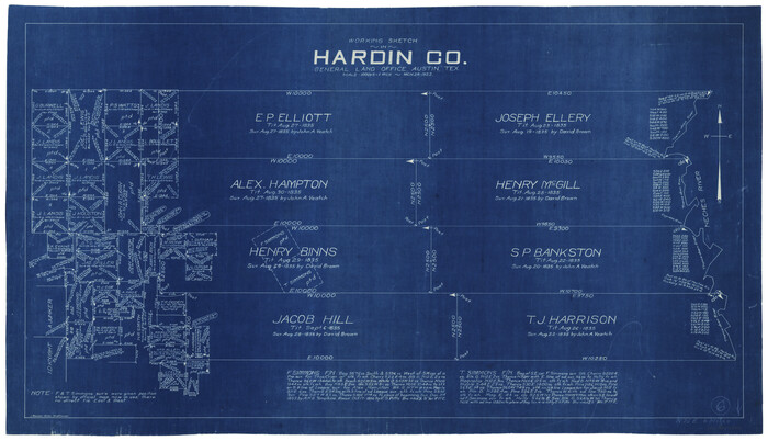
Hardin County Working Sketch 6
Print $20.00
- Digital $50.00
Hardin County Working Sketch 6
1922
Size 16.2 x 28.4 inches
Map/Doc 63404
Map of Germany, Switzerland and Northern Italy engraved to illustrate Mitchell's school and family geography

Print $20.00
- Digital $50.00
Map of Germany, Switzerland and Northern Italy engraved to illustrate Mitchell's school and family geography
1840
Size 11.8 x 9.5 inches
Map/Doc 93504
Sketch A Shewing the progress of the Survey in Section No. 1 From 1844 to 1852

Print $20.00
- Digital $50.00
Sketch A Shewing the progress of the Survey in Section No. 1 From 1844 to 1852
1852
Size 38.1 x 25.3 inches
Map/Doc 97200
You may also like
[Surveys on the south side of the Canadian River]
![91788, [Surveys on the south side of the Canadian River], Twichell Survey Records](https://historictexasmaps.com/wmedia_w700/maps/91788-1.tif.jpg)
Print $3.00
- Digital $50.00
[Surveys on the south side of the Canadian River]
Size 11.2 x 15.9 inches
Map/Doc 91788
Uvalde County Working Sketch Graphic Index

Print $20.00
- Digital $50.00
Uvalde County Working Sketch Graphic Index
1976
Size 42.5 x 46.2 inches
Map/Doc 76723
Wood County Working Sketch 13

Print $20.00
- Digital $50.00
Wood County Working Sketch 13
1973
Size 23.1 x 20.2 inches
Map/Doc 62013
Panola County Working Sketch 7

Print $20.00
- Digital $50.00
Panola County Working Sketch 7
1942
Map/Doc 71416
San Patricio County Sketch File 34

Print $4.00
- Digital $50.00
San Patricio County Sketch File 34
1961
Size 11.4 x 8.8 inches
Map/Doc 36119
General Highway Map. Detail of Cities and Towns in Bowie County, Texas

Print $20.00
General Highway Map. Detail of Cities and Towns in Bowie County, Texas
1961
Size 18.0 x 24.8 inches
Map/Doc 79381
![88940, Fisher Co[unty], Library of Congress](https://historictexasmaps.com/wmedia_w700/maps/88940.tif.jpg)
Henderson County Rolled Sketch 11

Print $20.00
- Digital $50.00
Henderson County Rolled Sketch 11
1915
Size 29.1 x 42.2 inches
Map/Doc 76150
Brazoria County Working Sketch 42

Print $20.00
- Digital $50.00
Brazoria County Working Sketch 42
1984
Size 43.5 x 47.1 inches
Map/Doc 67527

Victoria County Working Sketch 1

Print $20.00
- Digital $50.00
Victoria County Working Sketch 1
1938
Size 33.5 x 36.9 inches
Map/Doc 72271
[Surveys in Tyler County]
![352, [Surveys in Tyler County], General Map Collection](https://historictexasmaps.com/wmedia_w700/maps/352.tif.jpg)
Print $2.00
- Digital $50.00
[Surveys in Tyler County]
1847
Size 8.3 x 5.2 inches
Map/Doc 352