San Patricio County Sketch File 34
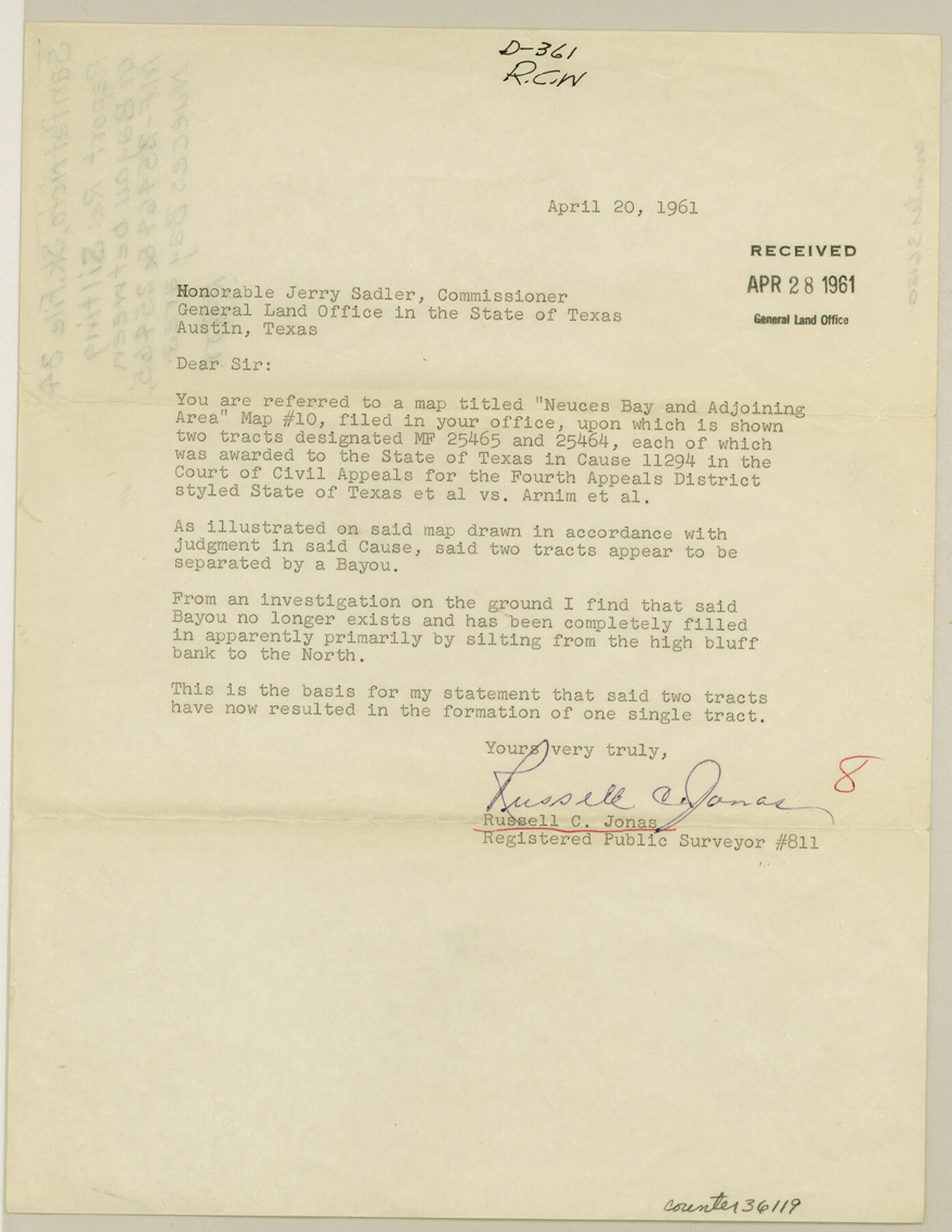
[Report regarding silting of bayou between MF-25464 and MF-25465, Nueces Bay area]
-
Map/Doc
36119
-
Collection
General Map Collection
-
Object Dates
4/20/1961 (Creation Date)
4/28/1961 (File Date)
-
People and Organizations
Russell C. Jonas (Surveyor/Engineer)
-
Counties
San Patricio
-
Subjects
Surveying Sketch File
-
Height x Width
11.4 x 8.8 inches
29.0 x 22.4 cm
-
Medium
paper, print
-
Features
Nueces Bay
Part of: General Map Collection
Coke County Sketch File 38

Print $42.00
- Digital $50.00
Coke County Sketch File 38
1858
Size 8.0 x 10.0 inches
Map/Doc 82529
Williamson County Sketch File 8

Print $4.00
- Digital $50.00
Williamson County Sketch File 8
1847
Size 12.8 x 8.0 inches
Map/Doc 40318
Lampasas County Sketch File 1

Print $4.00
- Digital $50.00
Lampasas County Sketch File 1
Size 12.6 x 8.1 inches
Map/Doc 29388
Eastland County Working Sketch 15

Print $20.00
- Digital $50.00
Eastland County Working Sketch 15
1919
Size 21.2 x 23.0 inches
Map/Doc 68796
Pecos County Working Sketch 108

Print $40.00
- Digital $50.00
Pecos County Working Sketch 108
1971
Size 43.5 x 56.3 inches
Map/Doc 71581
Montgomery County Working Sketch 25

Print $40.00
- Digital $50.00
Montgomery County Working Sketch 25
1941
Size 50.0 x 43.7 inches
Map/Doc 71132
Brazos River, Brazos River Sheet 5

Print $20.00
- Digital $50.00
Brazos River, Brazos River Sheet 5
1926
Size 27.4 x 21.7 inches
Map/Doc 69669
[Surveys along the Trinity River]
![298, [Surveys along the Trinity River], General Map Collection](https://historictexasmaps.com/wmedia_w700/maps/298.tif.jpg)
Print $2.00
- Digital $50.00
[Surveys along the Trinity River]
Size 6.3 x 9.2 inches
Map/Doc 298
Moore County Sketch File 5

Print $22.00
- Digital $50.00
Moore County Sketch File 5
Size 9.0 x 12.6 inches
Map/Doc 31937

Dawson County Sketch File 15

Print $40.00
- Digital $50.00
Dawson County Sketch File 15
Size 17.8 x 7.9 inches
Map/Doc 20549
Taylor County Working Sketch 4a

Print $20.00
- Digital $50.00
Taylor County Working Sketch 4a
1944
Size 17.2 x 14.0 inches
Map/Doc 69613
You may also like
Nueces County Aerial Photograph Index Sheet 23

Print $20.00
- Digital $50.00
Nueces County Aerial Photograph Index Sheet 23
1938
Size 24.4 x 20.3 inches
Map/Doc 86844

Taylor County Working Sketch 20

Print $40.00
- Digital $50.00
Taylor County Working Sketch 20
1985
Size 58.7 x 36.7 inches
Map/Doc 69630
Kent County Working Sketch 3b

Print $20.00
- Digital $50.00
Kent County Working Sketch 3b
1948
Size 24.9 x 23.3 inches
Map/Doc 70010
Navarro County Working Sketch 9

Print $20.00
- Digital $50.00
Navarro County Working Sketch 9
1956
Size 22.8 x 20.6 inches
Map/Doc 71239
Greer County Sketch File 1

Print $20.00
- Digital $50.00
Greer County Sketch File 1
Size 27.8 x 19.7 inches
Map/Doc 11581
Hall County Sketch File 14

Print $20.00
- Digital $50.00
Hall County Sketch File 14
1882
Size 20.9 x 32.9 inches
Map/Doc 11607
Flight Mission No. CRE-3R, Frame 40, Jackson County

Print $20.00
- Digital $50.00
Flight Mission No. CRE-3R, Frame 40, Jackson County
1956
Size 18.6 x 22.3 inches
Map/Doc 85387
Kleberg County Rolled Sketch 10-40

Print $20.00
- Digital $50.00
Kleberg County Rolled Sketch 10-40
1952
Size 38.1 x 34.0 inches
Map/Doc 9392
Duval County Working Sketch 4

Print $20.00
- Digital $50.00
Duval County Working Sketch 4
1928
Size 25.8 x 24.9 inches
Map/Doc 76445
[Sections 6 and 7, Block 12, H. & G. N.]
![91584, [Sections 6 and 7, Block 12, H. & G. N.], Twichell Survey Records](https://historictexasmaps.com/wmedia_w700/maps/91584-1.tif.jpg)
Print $2.00
- Digital $50.00
[Sections 6 and 7, Block 12, H. & G. N.]
Size 12.4 x 9.2 inches
Map/Doc 91584
