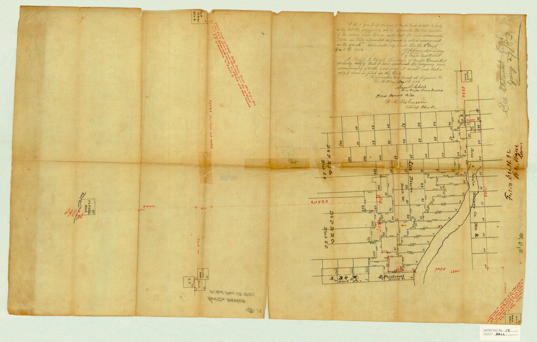
Hall County Sketch File 14
[Sketch of surveys on the south side of the Prairie Dog Town Fork of the Red River and surrounding area in the west part of the county and extending into Briscoe County]
-
Map/Doc
11607
-
Collection
General Map Collection
-
Object Dates
12/5/1882 (Creation Date)
12/13/1882 (File Date)
-
People and Organizations
W.A. Jones ()
-
Counties
Hall Briscoe
-
Subjects
Surveying Sketch File
-
Height x Width
20.9 x 32.9 inches
53.1 x 83.6 cm
-
Medium
paper, manuscript
-
Features
North Pease River
Pease River
Part of: General Map Collection
Lynn County Working Sketch Graphic Index

Print $20.00
- Digital $50.00
Lynn County Working Sketch Graphic Index
1961
Size 38.7 x 35.1 inches
Map/Doc 76627
Smith County Sketch File 5

Print $6.00
- Digital $50.00
Smith County Sketch File 5
1857
Size 8.4 x 7.8 inches
Map/Doc 36754
Young County Working Sketch 6

Print $20.00
- Digital $50.00
Young County Working Sketch 6
1919
Size 12.2 x 11.9 inches
Map/Doc 62029
Brazoria County Working Sketch 31

Print $20.00
- Digital $50.00
Brazoria County Working Sketch 31
1977
Size 26.3 x 31.7 inches
Map/Doc 67516
Map of Asylum & University lands situated on the waters of Hubbards Creek

Print $20.00
- Digital $50.00
Map of Asylum & University lands situated on the waters of Hubbards Creek
1857
Size 21.2 x 28.5 inches
Map/Doc 2491
Frio County Rolled Sketch 25

Print $20.00
- Digital $50.00
Frio County Rolled Sketch 25
1965
Size 25.0 x 30.6 inches
Map/Doc 5925
Crockett County Sketch File 52

Print $4.00
- Digital $50.00
Crockett County Sketch File 52
Size 9.5 x 8.8 inches
Map/Doc 19817
Chart of the Harbour of San [Luis]
![72761, Chart of the Harbour of San [Luis], General Map Collection](https://historictexasmaps.com/wmedia_w700/maps/72761.tif.jpg)
Print $20.00
- Digital $50.00
Chart of the Harbour of San [Luis]
1846
Size 27.3 x 18.3 inches
Map/Doc 72761
Sterling County Sketch File 22

Print $4.00
- Digital $50.00
Sterling County Sketch File 22
1954
Size 11.2 x 8.7 inches
Map/Doc 37182
Flight Mission No. BRE-1P, Frame 32, Nueces County

Print $20.00
- Digital $50.00
Flight Mission No. BRE-1P, Frame 32, Nueces County
1956
Size 18.4 x 22.6 inches
Map/Doc 86628
Reagan County Sketch File 17

Print $40.00
- Digital $50.00
Reagan County Sketch File 17
Size 11.8 x 14.2 inches
Map/Doc 35006
Smith County Working Sketch 7

Print $20.00
- Digital $50.00
Smith County Working Sketch 7
1941
Size 27.2 x 20.8 inches
Map/Doc 63892
You may also like
Newton County Working Sketch 11

Print $20.00
- Digital $50.00
Newton County Working Sketch 11
1941
Size 22.7 x 23.5 inches
Map/Doc 71257
Central America Past and Present

Central America Past and Present
1986
Size 20.6 x 31.6 inches
Map/Doc 96839
Kinney County Working Sketch 58

Print $20.00
- Digital $50.00
Kinney County Working Sketch 58
1996
Size 36.1 x 31.7 inches
Map/Doc 70240
Gray County Working Sketch 1

Print $40.00
- Digital $50.00
Gray County Working Sketch 1
Size 121.0 x 38.8 inches
Map/Doc 63232
Atascosa County Working Sketch 33

Print $20.00
- Digital $50.00
Atascosa County Working Sketch 33
1982
Size 16.7 x 13.6 inches
Map/Doc 67229

Van Zandt County Sketch File 42

Print $4.00
- Digital $50.00
Van Zandt County Sketch File 42
1874
Size 10.0 x 8.1 inches
Map/Doc 39495
Wilbarger County Sketch File 8

Print $4.00
- Digital $50.00
Wilbarger County Sketch File 8
1885
Size 14.2 x 8.6 inches
Map/Doc 40179
Flight Mission No. CRC-5R, Frame 42, Chambers County

Print $20.00
- Digital $50.00
Flight Mission No. CRC-5R, Frame 42, Chambers County
1956
Size 18.6 x 22.3 inches
Map/Doc 84961
Map of North Meadow Located on S. Part SE 1/4 Section

Print $20.00
- Digital $50.00
Map of North Meadow Located on S. Part SE 1/4 Section
Size 11.6 x 21.0 inches
Map/Doc 92284
Plan of the City of Indianola, Texas

Print $40.00
- Digital $50.00
Plan of the City of Indianola, Texas
1868
Size 37.5 x 55.3 inches
Map/Doc 4835
Shackelford County Boundary File 7a

Print $9.00
- Digital $50.00
Shackelford County Boundary File 7a
Size 14.9 x 9.4 inches
Map/Doc 58689