Wilbarger County Sketch File 8
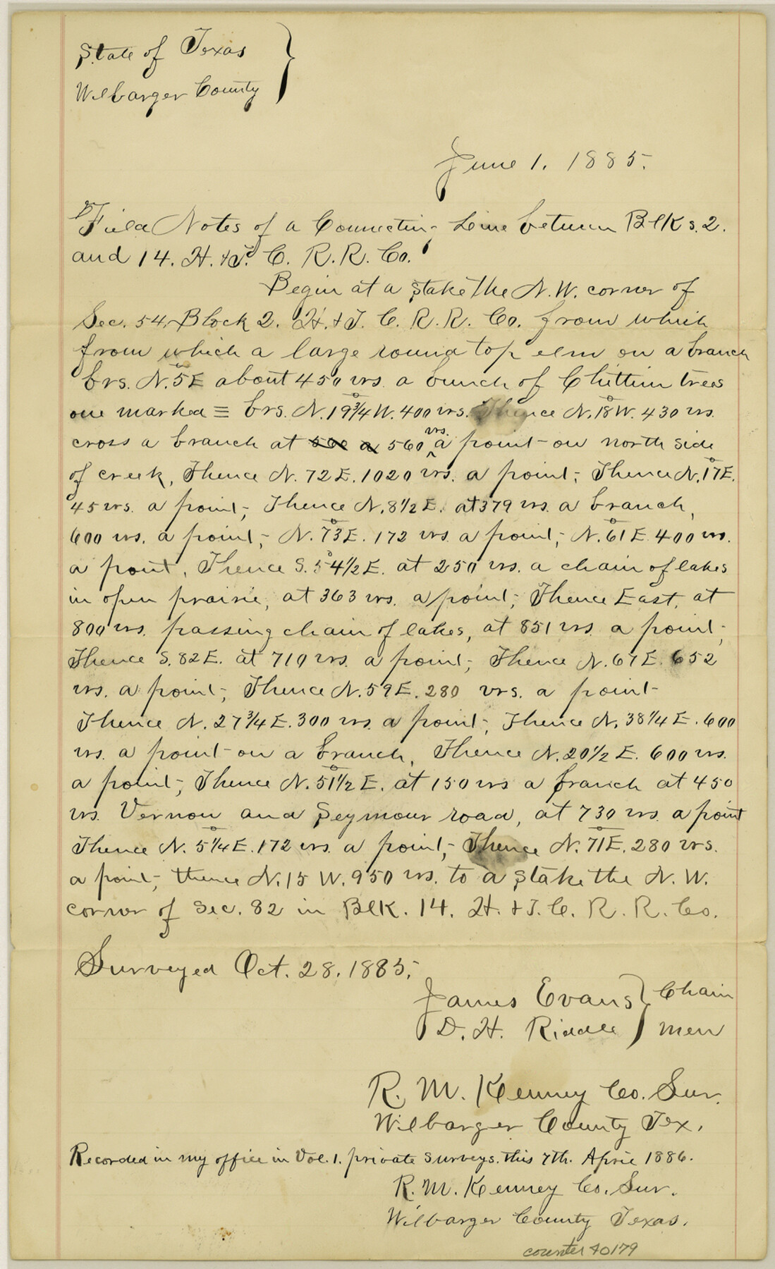
[Field notes of a connecting line between Blocks 2 and 14, H. & T. C. R.R. Co.]
-
Map/Doc
40179
-
Collection
General Map Collection
-
Object Dates
6/1/1885 (Creation Date)
4/10/1886 (File Date)
-
People and Organizations
James Evans (Chainman/Field Personnel)
D.H. Riddle (Chainman/Field Personnel)
R.M. Kenney (Surveyor/Engineer)
-
Counties
Wilbarger
-
Subjects
Surveying Sketch File
-
Height x Width
14.2 x 8.6 inches
36.1 x 21.8 cm
-
Medium
paper, bound volume
Part of: General Map Collection
Flight Mission No. CGI-3N, Frame 147, Cameron County

Print $20.00
- Digital $50.00
Flight Mission No. CGI-3N, Frame 147, Cameron County
1954
Size 18.8 x 22.4 inches
Map/Doc 84620
Aransas County Rolled Sketch 30

Print $40.00
- Digital $50.00
Aransas County Rolled Sketch 30
1909
Size 15.9 x 61.6 inches
Map/Doc 8422
Texas Coordinate File 7

Print $4.00
- Digital $50.00
Texas Coordinate File 7
Size 11.3 x 8.8 inches
Map/Doc 75316
Map of the Denison & South Eastern Rwy. showing the Location & Land Lines of the First Twenty-One Miles

Print $40.00
- Digital $50.00
Map of the Denison & South Eastern Rwy. showing the Location & Land Lines of the First Twenty-One Miles
1878
Size 24.1 x 70.4 inches
Map/Doc 64023
Childress County Sketch File 11

Print $6.00
- Digital $50.00
Childress County Sketch File 11
Size 14.0 x 8.6 inches
Map/Doc 18253
Travis County Working Sketch 27

Print $20.00
- Digital $50.00
Travis County Working Sketch 27
1951
Size 17.6 x 31.6 inches
Map/Doc 69411
Coke County Sketch File 9

Print $4.00
- Digital $50.00
Coke County Sketch File 9
Size 12.6 x 7.9 inches
Map/Doc 18585
Fractional Township No. 8 South Range No. 11 East of the Indian Meridian, Indian Territory

Print $20.00
- Digital $50.00
Fractional Township No. 8 South Range No. 11 East of the Indian Meridian, Indian Territory
1896
Size 19.3 x 24.4 inches
Map/Doc 75222
Dallas/Fort Worth Street Map & Visitor Guide

Dallas/Fort Worth Street Map & Visitor Guide
2000
Size 35.6 x 23.2 inches
Map/Doc 94295
Portion of States Submerged Area in Matagorda Bay

Print $20.00
- Digital $50.00
Portion of States Submerged Area in Matagorda Bay
1923
Size 12.7 x 13.5 inches
Map/Doc 2956
Sketch of the route taken by a scouting party from Phantom Hill to Double Mountain, Texas

Print $20.00
- Digital $50.00
Sketch of the route taken by a scouting party from Phantom Hill to Double Mountain, Texas
1852
Size 25.3 x 13.4 inches
Map/Doc 2006
Yoakum County Sketch File 14

Print $22.00
- Digital $50.00
Yoakum County Sketch File 14
1937
Size 14.5 x 14.6 inches
Map/Doc 40791
You may also like
Hockley County Working Sketch 2

Print $20.00
- Digital $50.00
Hockley County Working Sketch 2
1960
Size 17.8 x 35.7 inches
Map/Doc 66192
Polk County Sketch File 37

Print $18.00
- Digital $50.00
Polk County Sketch File 37
1901
Size 9.1 x 8.1 inches
Map/Doc 34259
Martha's Vineyard to Block Island Including Western Approach to Cape Cod Canal

Print $20.00
- Digital $50.00
Martha's Vineyard to Block Island Including Western Approach to Cape Cod Canal
1963
Size 51.1 x 36.9 inches
Map/Doc 73555
Val Verde County Working Sketch 62

Print $40.00
- Digital $50.00
Val Verde County Working Sketch 62
1959
Size 38.3 x 56.6 inches
Map/Doc 72197
Parker County Working Sketch 23

Print $20.00
- Digital $50.00
Parker County Working Sketch 23
2007
Map/Doc 87924
Brewster County Rolled Sketch 53

Print $20.00
- Digital $50.00
Brewster County Rolled Sketch 53
1934
Size 43.8 x 37.6 inches
Map/Doc 8480

[Beaumont, Sour Lake and Western Ry. Right of Way and Alignment - Frisco]
![64127, [Beaumont, Sour Lake and Western Ry. Right of Way and Alignment - Frisco], General Map Collection](https://historictexasmaps.com/wmedia_w700/maps/64127.tif.jpg)
Print $20.00
- Digital $50.00
[Beaumont, Sour Lake and Western Ry. Right of Way and Alignment - Frisco]
1910
Size 20.1 x 45.8 inches
Map/Doc 64127
Wichita County Working Sketch 18

Print $20.00
- Digital $50.00
Wichita County Working Sketch 18
1948
Size 34.9 x 20.8 inches
Map/Doc 72528
Loving County Rolled Sketch 19

Print $20.00
- Digital $50.00
Loving County Rolled Sketch 19
2020
Size 24.4 x 35.3 inches
Map/Doc 96575
Sketch Showing Division Fence Shelton- Matador, Oldham County, Texas

Print $20.00
- Digital $50.00
Sketch Showing Division Fence Shelton- Matador, Oldham County, Texas
Size 21.2 x 23.0 inches
Map/Doc 91427
Jackson County Working Sketch 8

Print $20.00
- Digital $50.00
Jackson County Working Sketch 8
1980
Size 30.4 x 29.0 inches
Map/Doc 66456