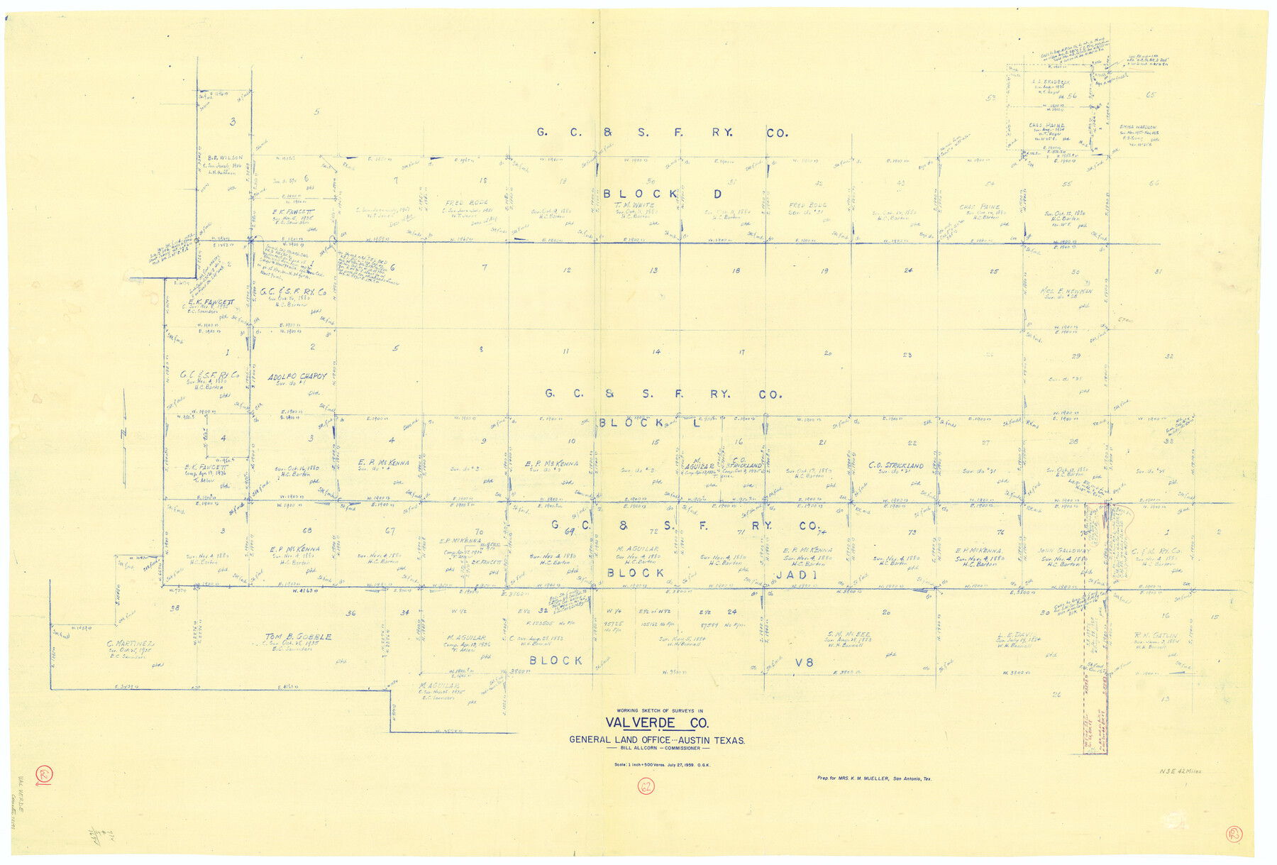
Val Verde County Working Sketch 62
-
Map/Doc
72197
-
Collection
General Map Collection
-
Object Dates
7/27/1959 (Creation Date)
-
People and Organizations
Otto G. Kurio (Draftsman)
-
Counties
Val Verde
-
Subjects
Surveying Working Sketch
-
Height x Width
38.3 x 56.6 inches
97.3 x 143.8 cm
-
Scale
1" = 500 varas
Part of: General Map Collection
Dimmit County Rolled Sketch 3

Print $20.00
- Digital $50.00
Dimmit County Rolled Sketch 3
Size 31.9 x 36.2 inches
Map/Doc 76142
Terry County Rolled Sketch 10

Print $20.00
- Digital $50.00
Terry County Rolled Sketch 10
2001
Size 25.2 x 23.8 inches
Map/Doc 76414
Shackelford County Boundary File 2

Print $88.00
- Digital $50.00
Shackelford County Boundary File 2
Size 8.7 x 5.3 inches
Map/Doc 58633
Brazos River, Gurley Sheet

Print $6.00
- Digital $50.00
Brazos River, Gurley Sheet
1929
Size 33.1 x 30.2 inches
Map/Doc 65282
Coast Chart No. 210 Aransas Pass and Corpus Christi Bay with the coast to latitude 27° 12' Texas

Print $20.00
- Digital $50.00
Coast Chart No. 210 Aransas Pass and Corpus Christi Bay with the coast to latitude 27° 12' Texas
1913
Size 27.6 x 18.2 inches
Map/Doc 72807
Pecos County Working Sketch 136

Print $20.00
- Digital $50.00
Pecos County Working Sketch 136
1981
Size 31.8 x 28.4 inches
Map/Doc 71610

Jack County Sketch File 18b

Print $4.00
- Digital $50.00
Jack County Sketch File 18b
Size 8.0 x 12.9 inches
Map/Doc 27557
Brewster County Rolled Sketch 113

Print $171.00
- Digital $50.00
Brewster County Rolled Sketch 113
1975
Map/Doc 9565
Houston Ship Channel, Alexander Island to Carpenter Bayou

Print $20.00
- Digital $50.00
Houston Ship Channel, Alexander Island to Carpenter Bayou
1960
Size 34.8 x 46.2 inches
Map/Doc 69906
United States - Gulf Coast - Galveston to Rio Grande

Print $20.00
- Digital $50.00
United States - Gulf Coast - Galveston to Rio Grande
1940
Size 27.0 x 18.2 inches
Map/Doc 72755
Reeves County Rolled Sketch 33

Print $20.00
- Digital $50.00
Reeves County Rolled Sketch 33
Size 24.6 x 36.9 inches
Map/Doc 7504
You may also like
Dallas County Boundary File 6e

Print $70.00
- Digital $50.00
Dallas County Boundary File 6e
Size 16.6 x 22.5 inches
Map/Doc 52254
Map of Potter County

Print $20.00
- Digital $50.00
Map of Potter County
1895
Size 27.0 x 21.1 inches
Map/Doc 3966
Harrison County Working Sketch Graphic Index

Print $20.00
- Digital $50.00
Harrison County Working Sketch Graphic Index
1920
Size 44.9 x 41.7 inches
Map/Doc 76570
Mitchell County

Print $20.00
- Digital $50.00
Mitchell County
1889
Size 42.3 x 35.7 inches
Map/Doc 10792
Cochran County Boundary File 3

Print $160.00
- Digital $50.00
Cochran County Boundary File 3
Size 6.7 x 15.3 inches
Map/Doc 51476
Donley County Sketch File 9

Print $4.00
- Digital $50.00
Donley County Sketch File 9
1884
Size 6.6 x 7.7 inches
Map/Doc 21238
Caldwell County Working Sketch 6

Print $20.00
- Digital $50.00
Caldwell County Working Sketch 6
1958
Size 21.8 x 26.3 inches
Map/Doc 67836
Nolan County, Texas

Print $20.00
- Digital $50.00
Nolan County, Texas
1880
Size 29.5 x 22.7 inches
Map/Doc 588
Working Sketch Dickens and Kent Counties

Print $20.00
- Digital $50.00
Working Sketch Dickens and Kent Counties
1904
Size 16.3 x 20.7 inches
Map/Doc 90862
Goliad County Sketch File 20

Print $38.00
- Digital $50.00
Goliad County Sketch File 20
1887
Size 8.8 x 12.3 inches
Map/Doc 24265
The Mexican Municipality of Brazoria. December 28, 1834

Print $20.00
The Mexican Municipality of Brazoria. December 28, 1834
2020
Size 16.5 x 21.7 inches
Map/Doc 96017
Aransas County Sketch File 30

Print $74.00
- Digital $50.00
Aransas County Sketch File 30
Size 14.2 x 8.7 inches
Map/Doc 13237