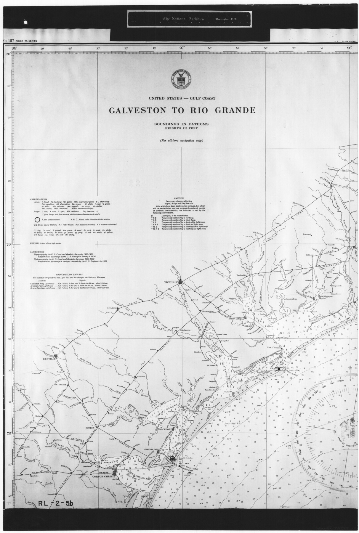
United States - Gulf Coast - Galveston to Rio Grande
RL-2-5b
-
Map/Doc
72755
-
Collection
General Map Collection
-
Object Dates
1940 (Creation Date)
-
People and Organizations
U. S. Coast and Geodetic Survey (Publisher)
-
Subjects
Nautical Charts
-
Height x Width
27.0 x 18.2 inches
68.6 x 46.2 cm
-
Comments
B/W photostat copy from National Archives in multiple pieces.
Part of: General Map Collection
Neches River, Texas Agricultural Experiment Station

Print $4.00
- Digital $50.00
Neches River, Texas Agricultural Experiment Station
1940
Size 21.7 x 20.6 inches
Map/Doc 65080
Texas 1849: A Lone Star Rising

Print $20.00
- Digital $50.00
Texas 1849: A Lone Star Rising
2000
Size 40.6 x 40.7 inches
Map/Doc 78270
Flight Mission No. CGI-3N, Frame 101, Cameron County

Print $20.00
- Digital $50.00
Flight Mission No. CGI-3N, Frame 101, Cameron County
1954
Size 18.6 x 22.1 inches
Map/Doc 84581
Carte d'une partie de l'Asie, depuis la Mer Méditerranée jusqu'au Golfe de Cambaye dans la Mer de l'Inde

Print $20.00
- Digital $50.00
Carte d'une partie de l'Asie, depuis la Mer Méditerranée jusqu'au Golfe de Cambaye dans la Mer de l'Inde
1782
Size 12.9 x 18.0 inches
Map/Doc 97120
Flight Mission No. DQN-1K, Frame 27, Calhoun County

Print $20.00
- Digital $50.00
Flight Mission No. DQN-1K, Frame 27, Calhoun County
1953
Size 18.5 x 22.1 inches
Map/Doc 84132
Hutchinson County Sketch File 22

Print $4.00
- Digital $50.00
Hutchinson County Sketch File 22
1906
Size 13.0 x 8.5 inches
Map/Doc 27243
Brazoria County NRC Article 33.136 Sketch 4

Print $22.00
- Digital $50.00
Brazoria County NRC Article 33.136 Sketch 4
2003
Size 24.3 x 35.8 inches
Map/Doc 80120
Harris County Sketch File 29

Print $15.00
- Digital $50.00
Harris County Sketch File 29
Size 14.1 x 9.0 inches
Map/Doc 25409
Intracoastal Waterway - Gibbstown to Port Arthur

Print $20.00
- Digital $50.00
Intracoastal Waterway - Gibbstown to Port Arthur
1957
Size 27.1 x 38.8 inches
Map/Doc 69829
Southern Part of Laguna Madre

Print $20.00
- Digital $50.00
Southern Part of Laguna Madre
1985
Size 45.3 x 36.6 inches
Map/Doc 73547
Andrews County Working Sketch 12

Print $20.00
- Digital $50.00
Andrews County Working Sketch 12
1956
Size 35.5 x 25.3 inches
Map/Doc 67058
Parker County Sketch File 46

Print $26.00
- Digital $50.00
Parker County Sketch File 46
1957
Size 11.2 x 8.5 inches
Map/Doc 33615
You may also like
[Jones County School Land, Blocks P, D, D6, and CB]
![91091, [Jones County School Land, Blocks P, D, D6, and CB], Twichell Survey Records](https://historictexasmaps.com/wmedia_w700/maps/91091-1.tif.jpg)
Print $2.00
- Digital $50.00
[Jones County School Land, Blocks P, D, D6, and CB]
1907
Size 8.0 x 14.5 inches
Map/Doc 91091
[Surveys by Brown in Austin's Little Colony along the Colorado River and Walnut Creek]
![196, [Surveys by Brown in Austin's Little Colony along the Colorado River and Walnut Creek], General Map Collection](https://historictexasmaps.com/wmedia_w700/maps/196.tif.jpg)
Print $20.00
- Digital $50.00
[Surveys by Brown in Austin's Little Colony along the Colorado River and Walnut Creek]
1832
Size 33.2 x 23.3 inches
Map/Doc 196

Harris County Rolled Sketch 72

Print $40.00
- Digital $50.00
Harris County Rolled Sketch 72
1945
Size 23.0 x 48.3 inches
Map/Doc 9132
Terrell County

Print $20.00
- Digital $50.00
Terrell County
1905
Size 30.7 x 33.8 inches
Map/Doc 92806
Liberty County Working Sketch 9

Print $20.00
- Digital $50.00
Liberty County Working Sketch 9
Size 34.6 x 27.3 inches
Map/Doc 70468
Colorado County Rolled Sketch 4

Print $20.00
- Digital $50.00
Colorado County Rolled Sketch 4
1944
Size 31.9 x 21.9 inches
Map/Doc 8643
Hunt County Boundary File 8

Print $8.00
- Digital $50.00
Hunt County Boundary File 8
Size 14.6 x 8.9 inches
Map/Doc 55237
Galveston County Sketch File 31

Print $20.00
- Digital $50.00
Galveston County Sketch File 31
1916
Size 23.7 x 13.6 inches
Map/Doc 11534
Floyd County Rolled Sketch 5

Print $20.00
- Digital $50.00
Floyd County Rolled Sketch 5
1892
Size 27.2 x 18.7 inches
Map/Doc 5880
[Map showing connecting line from New Mexico to Double Lakes]
![91998, [Map showing connecting line from New Mexico to Double Lakes], Twichell Survey Records](https://historictexasmaps.com/wmedia_w700/maps/91998-1.tif.jpg)
Print $20.00
- Digital $50.00
[Map showing connecting line from New Mexico to Double Lakes]
1913
Size 39.6 x 24.2 inches
Map/Doc 91998
Castro County Working Sketch 4

Print $20.00
- Digital $50.00
Castro County Working Sketch 4
1920
Size 17.0 x 16.2 inches
Map/Doc 67899