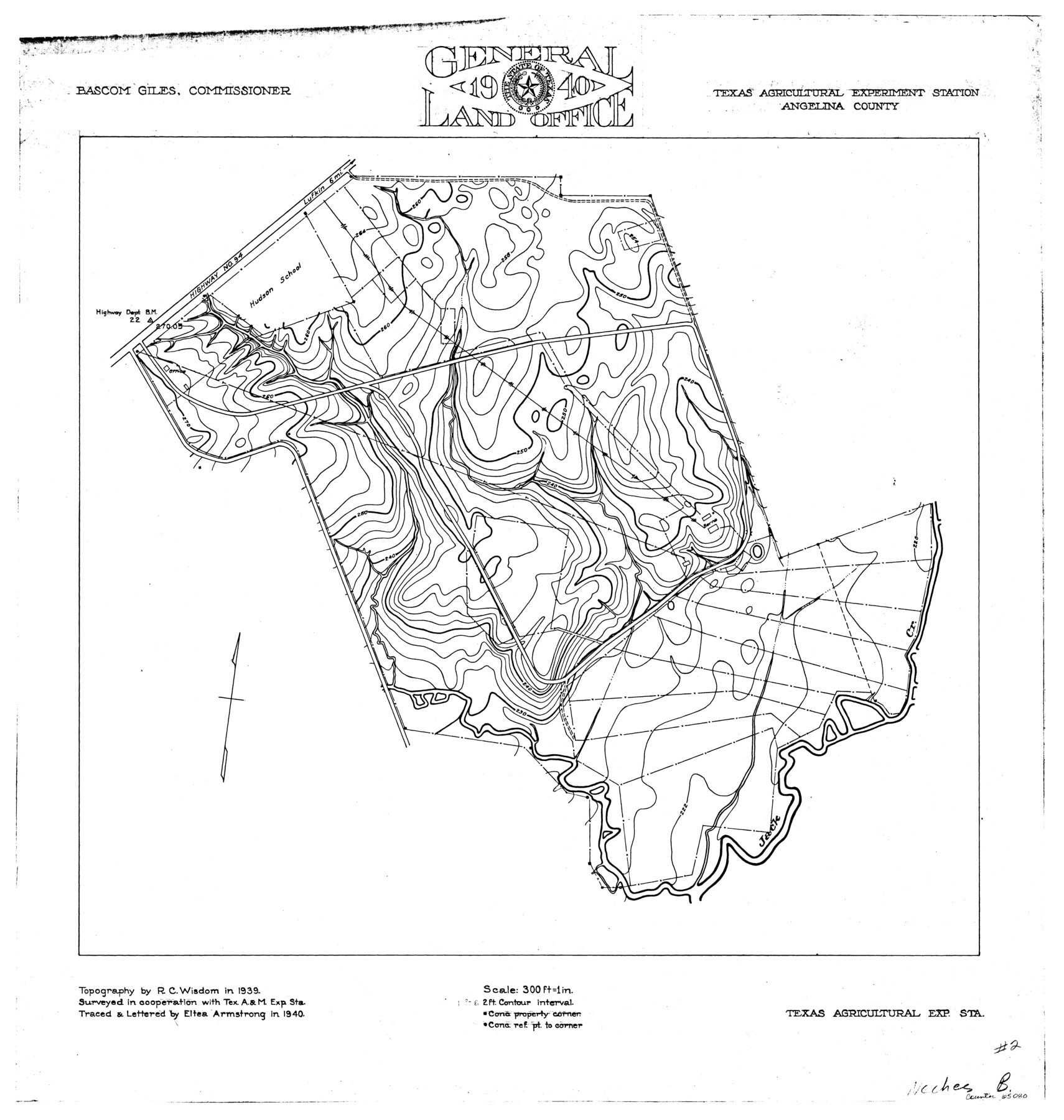
Neches River, Texas Agricultural Experiment Station
-
Map/Doc
65080
-
Collection
General Map Collection
-
Object Dates
1940 (Creation Date)
-
People and Organizations
Texas General Land Office (Publisher)
Eltea Armstrong (Compiler)
Eltea Armstrong (Draftsman)
Bascom Giles (GLO Commissioner)
R.C. Wisdom (Surveyor/Engineer)
-
Counties
Angelina
-
Subjects
River Surveys Topographic
-
Height x Width
21.7 x 20.6 inches
55.1 x 52.3 cm
Part of: General Map Collection
Travis County Sketch File 31

Print $4.00
- Digital $50.00
Travis County Sketch File 31
1889
Size 12.9 x 8.8 inches
Map/Doc 38345
Wise County Sketch File 49

Print $20.00
- Digital $50.00
Wise County Sketch File 49
1882
Size 15.5 x 20.8 inches
Map/Doc 12702
Shackelford County Working Sketch 2

Print $20.00
- Digital $50.00
Shackelford County Working Sketch 2
1914
Size 17.2 x 17.3 inches
Map/Doc 63842
San Augustine County Sketch File 7

Print $4.00
San Augustine County Sketch File 7
1858
Size 7.0 x 8.2 inches
Map/Doc 35646
Maps of Gulf Intracoastal Waterway, Texas - Sabine River to the Rio Grande and connecting waterways including ship channels

Print $20.00
- Digital $50.00
Maps of Gulf Intracoastal Waterway, Texas - Sabine River to the Rio Grande and connecting waterways including ship channels
1966
Size 14.5 x 22.2 inches
Map/Doc 61928
Crane County Rolled Sketch 27

Print $20.00
- Digital $50.00
Crane County Rolled Sketch 27
2020
Size 36.3 x 24.3 inches
Map/Doc 96433
Matagorda Light to Aransas Pass

Print $20.00
- Digital $50.00
Matagorda Light to Aransas Pass
1924
Size 35.9 x 44.6 inches
Map/Doc 73391
Montgomery County Working Sketch 18

Print $20.00
- Digital $50.00
Montgomery County Working Sketch 18
1935
Size 34.0 x 39.1 inches
Map/Doc 71125
Maverick County

Print $20.00
- Digital $50.00
Maverick County
1863
Size 24.4 x 36.6 inches
Map/Doc 3847
Goliad County Sketch File 13

Print $8.00
- Digital $50.00
Goliad County Sketch File 13
1856
Size 12.4 x 8.0 inches
Map/Doc 24239
Flight Mission No. CLL-3N, Frame 6, Willacy County

Print $20.00
- Digital $50.00
Flight Mission No. CLL-3N, Frame 6, Willacy County
1954
Size 18.5 x 22.2 inches
Map/Doc 87072
Terrell County Working Sketch 50

Print $40.00
- Digital $50.00
Terrell County Working Sketch 50
1958
Size 43.0 x 64.3 inches
Map/Doc 62143
You may also like
Howard County Sketch File 15

Print $6.00
- Digital $50.00
Howard County Sketch File 15
Size 11.2 x 8.8 inches
Map/Doc 26875
Ownership Map SE 1/4 Lubbock County

Print $20.00
- Digital $50.00
Ownership Map SE 1/4 Lubbock County
Size 37.2 x 36.4 inches
Map/Doc 89895
San Patricio County Rolled Sketch 50

Print $29.00
- Digital $50.00
San Patricio County Rolled Sketch 50
1988
Size 18.2 x 23.5 inches
Map/Doc 7736
[Maps of surveys in Reeves & Culberson Cos]
![61143, [Maps of surveys in Reeves & Culberson Cos], General Map Collection](https://historictexasmaps.com/wmedia_w700/maps/61143.tif.jpg)
Print $20.00
- Digital $50.00
[Maps of surveys in Reeves & Culberson Cos]
1937
Size 30.7 x 24.9 inches
Map/Doc 61143
Brewster County Rolled Sketch 11A

Print $20.00
- Digital $50.00
Brewster County Rolled Sketch 11A
1881
Size 24.9 x 23.0 inches
Map/Doc 5192
Upshur County Working Sketch 12

Print $20.00
- Digital $50.00
Upshur County Working Sketch 12
1984
Size 31.9 x 29.6 inches
Map/Doc 69569
La Salle County Working Sketch 23

Print $20.00
- Digital $50.00
La Salle County Working Sketch 23
1947
Size 30.5 x 31.6 inches
Map/Doc 70324
Duval County Working Sketch 25

Print $20.00
- Digital $50.00
Duval County Working Sketch 25
1946
Size 23.7 x 20.1 inches
Map/Doc 68749
Tom Green County Rolled Sketch 25

Print $20.00
- Digital $50.00
Tom Green County Rolled Sketch 25
1882
Size 14.0 x 18.5 inches
Map/Doc 8007
Liberty County Sketch File 24

Print $6.00
- Digital $50.00
Liberty County Sketch File 24
Size 10.2 x 7.9 inches
Map/Doc 29936
Duval County Sketch File 38

Print $64.00
- Digital $50.00
Duval County Sketch File 38
Size 38.2 x 19.5 inches
Map/Doc 10372
Flight Mission No. BRE-1P, Frame 78, Nueces County

Print $20.00
- Digital $50.00
Flight Mission No. BRE-1P, Frame 78, Nueces County
1956
Size 18.6 x 22.4 inches
Map/Doc 86660