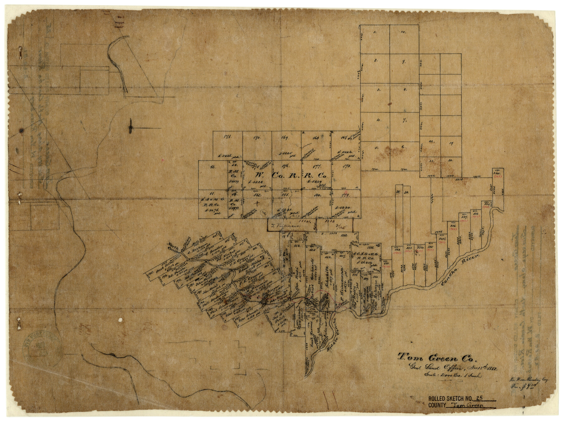
Tom Green County Rolled Sketch 25
[Sketch in Tom Green Co. showing surveys along and north of the Concho River]
-
Map/Doc
8007
-
Collection
General Map Collection
-
Object Dates
11/13/1882 (Creation Date)
11/13/1882 (File Date)
-
Counties
Tom Green
-
Subjects
Surveying Rolled Sketch
-
Height x Width
14.0 x 18.5 inches
35.6 x 47.0 cm
-
Medium
paper, manuscript
-
Scale
1" = 2000 varas
Part of: General Map Collection
Bexar County Rolled Sketch 4

Print $20.00
- Digital $50.00
Bexar County Rolled Sketch 4
Size 24.3 x 36.8 inches
Map/Doc 5137
Tyler County Sketch File 21

Print $4.00
- Digital $50.00
Tyler County Sketch File 21
1906
Size 10.9 x 9.1 inches
Map/Doc 38677
Hopkins County Working Sketch 3

Print $20.00
- Digital $50.00
Hopkins County Working Sketch 3
1955
Size 24.2 x 20.0 inches
Map/Doc 66228
[Map of Block 97, Borden and Scurry Co (Exhibit A); Map of Southeastern part of Young Territory; Map of part of of Borden, Fisher, Kent, Mitchell, Scurry and Garza Cos. Showing the north boundary line of the T&P 80 mile reservation]
![65690, [Map of Block 97, Borden and Scurry Co (Exhibit A); Map of Southeastern part of Young Territory; Map of part of of Borden, Fisher, Kent, Mitchell, Scurry and Garza Cos. Showing the north boundary line of the T&P 80 mile reservation], General Map Collection](https://historictexasmaps.com/wmedia_w700/maps/65690-1.tif.jpg)
Print $40.00
- Digital $50.00
[Map of Block 97, Borden and Scurry Co (Exhibit A); Map of Southeastern part of Young Territory; Map of part of of Borden, Fisher, Kent, Mitchell, Scurry and Garza Cos. Showing the north boundary line of the T&P 80 mile reservation]
Size 58.7 x 42.4 inches
Map/Doc 65690
Kaufman County Sketch File 19

Print $30.00
- Digital $50.00
Kaufman County Sketch File 19
1922
Size 11.2 x 8.7 inches
Map/Doc 28666
Calhoun County NRC Article 33.136 Sketch 9

Print $106.00
- Digital $50.00
Calhoun County NRC Article 33.136 Sketch 9
2021
Map/Doc 96913
Uvalde County Rolled Sketch 17

Print $20.00
- Digital $50.00
Uvalde County Rolled Sketch 17
Size 26.7 x 22.2 inches
Map/Doc 8101
Val Verde County Sketch File A4

Print $10.00
- Digital $50.00
Val Verde County Sketch File A4
1897
Size 9.2 x 8.5 inches
Map/Doc 39046
Flight Mission No. CRC-3R, Frame 35, Chambers County

Print $20.00
- Digital $50.00
Flight Mission No. CRC-3R, Frame 35, Chambers County
1956
Size 18.5 x 22.2 inches
Map/Doc 84808
Shelby County Sketch File 22

Print $6.00
- Digital $50.00
Shelby County Sketch File 22
Size 15.4 x 10.2 inches
Map/Doc 36643
Foard County Rolled Sketch 15

Print $20.00
- Digital $50.00
Foard County Rolled Sketch 15
1889
Size 19.9 x 38.3 inches
Map/Doc 5890
Roberts County Sketch File 7

Print $16.00
- Digital $50.00
Roberts County Sketch File 7
1992
Size 14.3 x 8.8 inches
Map/Doc 35316
You may also like
Webb County Working Sketch 90

Print $20.00
- Digital $50.00
Webb County Working Sketch 90
1982
Size 26.9 x 25.5 inches
Map/Doc 72457
[Northwest Portion of King County]
![90978, [Northwest Portion of King County], Twichell Survey Records](https://historictexasmaps.com/wmedia_w700/maps/90978-1.tif.jpg)
Print $20.00
- Digital $50.00
[Northwest Portion of King County]
Size 28.7 x 35.7 inches
Map/Doc 90978
[Blocks K3-K8, K11]
![90611, [Blocks K3-K8, K11], Twichell Survey Records](https://historictexasmaps.com/wmedia_w700/maps/90611-1.tif.jpg)
Print $20.00
- Digital $50.00
[Blocks K3-K8, K11]
Size 16.8 x 17.2 inches
Map/Doc 90611
Flight Mission No. CRE-2R, Frame 81, Jackson County

Print $20.00
- Digital $50.00
Flight Mission No. CRE-2R, Frame 81, Jackson County
1956
Size 18.6 x 22.2 inches
Map/Doc 85353
Val Verde County Rolled Sketch 72

Print $20.00
- Digital $50.00
Val Verde County Rolled Sketch 72
Size 15.2 x 28.5 inches
Map/Doc 8134
Kerr County Sketch File 24

Print $20.00
- Digital $50.00
Kerr County Sketch File 24
1967
Size 15.7 x 21.6 inches
Map/Doc 11923
Brown County Sketch File 27

Print $4.00
- Digital $50.00
Brown County Sketch File 27
1868
Size 13.3 x 8.1 inches
Map/Doc 16624
Concho County Working Sketch 11

Print $20.00
- Digital $50.00
Concho County Working Sketch 11
1951
Size 22.0 x 23.2 inches
Map/Doc 68193
Montgomery County Rolled Sketch 10

Print $20.00
- Digital $50.00
Montgomery County Rolled Sketch 10
1905
Size 35.5 x 26.2 inches
Map/Doc 6796
Loving County Working Sketch 16

Print $40.00
- Digital $50.00
Loving County Working Sketch 16
1973
Size 33.3 x 54.1 inches
Map/Doc 70649
[F. W. & D. C. Ry. Co. Alignment and Right of Way Map, Clay County]
![64745, [F. W. & D. C. Ry. Co. Alignment and Right of Way Map, Clay County], General Map Collection](https://historictexasmaps.com/wmedia_w700/maps/64745-GC.tif.jpg)
Print $20.00
- Digital $50.00
[F. W. & D. C. Ry. Co. Alignment and Right of Way Map, Clay County]
1927
Size 18.7 x 11.8 inches
Map/Doc 64745
Land Grant Map of Comal County

Print $20.00
- Digital $50.00
Land Grant Map of Comal County
2006
Size 33.3 x 41.0 inches
Map/Doc 83601