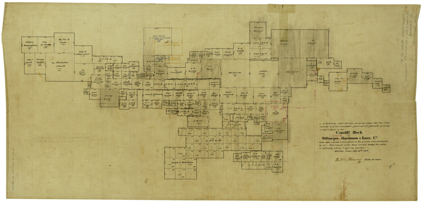
Foard County Rolled Sketch 15
Cundiff Block in Foard & Knox Cos.
-
Map/Doc
5890
-
Collection
General Map Collection
-
Object Dates
12/19/1889 (Creation Date)
-
People and Organizations
R.M. Kenney (Surveyor/Engineer)
-
Counties
Foard
-
Subjects
Surveying Rolled Sketch
-
Height x Width
19.9 x 38.3 inches
50.6 x 97.3 cm
-
Medium
linen, manuscript
-
Comments
See Foard County Sketch File 38 (22871) for correspondence.
Related maps
Foard County Sketch File 38

Print $11.00
- Digital $50.00
Foard County Sketch File 38
1890
Size 11.1 x 7.2 inches
Map/Doc 22871
Part of: General Map Collection
Chambers County Working Sketch 18

Print $20.00
- Digital $50.00
Chambers County Working Sketch 18
1965
Size 39.8 x 29.2 inches
Map/Doc 68001
United States Gulf Coast - from Galveston to the Rio Grande

Print $20.00
- Digital $50.00
United States Gulf Coast - from Galveston to the Rio Grande
1915
Size 26.3 x 18.3 inches
Map/Doc 72731
Map of Zavalla County

Print $20.00
- Digital $50.00
Map of Zavalla County
1876
Size 22.5 x 33.2 inches
Map/Doc 4181
City of Aransas Pass and Chart of Aransas Bay and Corpus Christi Bay, Texas

Print $20.00
- Digital $50.00
City of Aransas Pass and Chart of Aransas Bay and Corpus Christi Bay, Texas
1905
Size 28.4 x 21.4 inches
Map/Doc 97265
Kenedy County Rolled Sketch 14

Print $21.00
- Digital $50.00
Kenedy County Rolled Sketch 14
1951
Size 10.2 x 15.3 inches
Map/Doc 46433
Colorado County Working Sketch 7

Print $20.00
- Digital $50.00
Colorado County Working Sketch 7
1922
Size 23.8 x 23.2 inches
Map/Doc 68107
Anderson County Working Sketch 9

Print $20.00
- Digital $50.00
Anderson County Working Sketch 9
1929
Size 30.7 x 22.1 inches
Map/Doc 67008
Zavala County Rolled Sketch 30

Print $20.00
- Digital $50.00
Zavala County Rolled Sketch 30
Size 18.6 x 19.1 inches
Map/Doc 8331
Llano County Sketch File 10

Print $10.00
- Digital $50.00
Llano County Sketch File 10
1886
Size 8.2 x 7.6 inches
Map/Doc 30370
Sterling County Rolled Sketch 12

Print $20.00
- Digital $50.00
Sterling County Rolled Sketch 12
1941
Size 35.6 x 35.0 inches
Map/Doc 9946
Flight Mission No. BQR-20K, Frame 3, Brazoria County

Print $20.00
- Digital $50.00
Flight Mission No. BQR-20K, Frame 3, Brazoria County
1952
Size 18.6 x 22.2 inches
Map/Doc 84105
Kleberg County Rolled Sketch 7

Print $20.00
- Digital $50.00
Kleberg County Rolled Sketch 7
1947
Size 28.5 x 41.4 inches
Map/Doc 6550
You may also like
Pecos County Working Sketch 126

Print $40.00
- Digital $50.00
Pecos County Working Sketch 126
1974
Size 83.6 x 38.2 inches
Map/Doc 71599
Bell County Working Sketch Graphic Index

Print $40.00
- Digital $50.00
Bell County Working Sketch Graphic Index
1945
Size 42.6 x 52.8 inches
Map/Doc 76465

Comal County Sketch File 7

Print $4.00
- Digital $50.00
Comal County Sketch File 7
Size 13.5 x 8.3 inches
Map/Doc 19011
Cass County Working Sketch 53

Print $20.00
- Digital $50.00
Cass County Working Sketch 53
2007
Size 30.2 x 36.0 inches
Map/Doc 88608
Kendall County Boundary File 2b

Print $4.00
- Digital $50.00
Kendall County Boundary File 2b
Size 10.0 x 8.0 inches
Map/Doc 55754
Harris County Working Sketch 52

Print $20.00
- Digital $50.00
Harris County Working Sketch 52
1947
Size 33.9 x 42.4 inches
Map/Doc 65944
Burnet County Rolled Sketch 9

Print $40.00
- Digital $50.00
Burnet County Rolled Sketch 9
1971
Size 37.7 x 51.3 inches
Map/Doc 8545
[Right of Way & Track Map, The Texas & Pacific Ry. Co. Main Line]
![64669, [Right of Way & Track Map, The Texas & Pacific Ry. Co. Main Line], General Map Collection](https://historictexasmaps.com/wmedia_w700/maps/64669.tif.jpg)
Print $20.00
- Digital $50.00
[Right of Way & Track Map, The Texas & Pacific Ry. Co. Main Line]
Size 11.0 x 18.5 inches
Map/Doc 64669
Victoria County Rolled Sketch 1

Print $20.00
- Digital $50.00
Victoria County Rolled Sketch 1
1902
Size 20.5 x 17.5 inches
Map/Doc 8150
Gulf of Mexico

Print $20.00
- Digital $50.00
Gulf of Mexico
1961
Size 36.6 x 43.3 inches
Map/Doc 73551
Young County Rolled Sketch 2

Print $20.00
- Digital $50.00
Young County Rolled Sketch 2
Size 26.2 x 25.0 inches
Map/Doc 8292