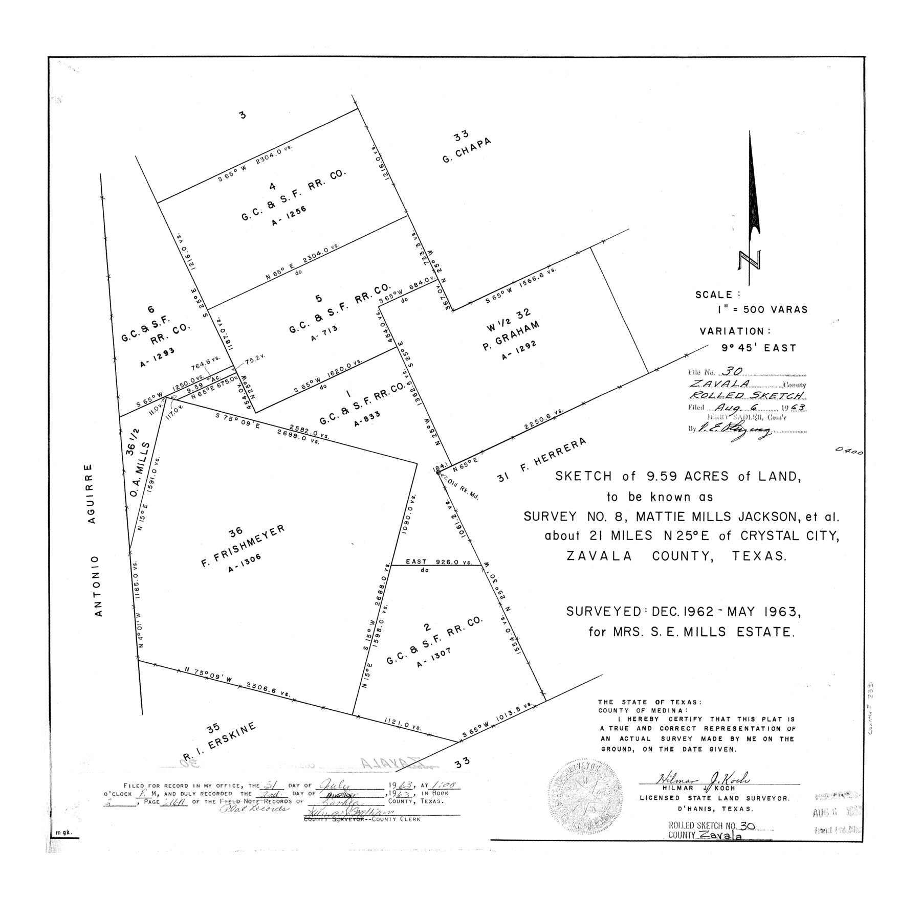
Zavala County Rolled Sketch 30
Sketch of 9.59 acres of land to be known as survey no. 8, Mattie Mills Jackson, et al.
-
Map/Doc
8331
-
Collection
General Map Collection
-
Object Dates
1963 (Survey Date)
1963/8/6 (File Date)
-
People and Organizations
Hilmar J. Koch (Surveyor/Engineer)
-
Counties
Zavala
-
Subjects
Surveying Rolled Sketch
-
Height x Width
18.6 x 19.1 inches
47.2 x 48.5 cm
-
Medium
linen, manuscript
-
Scale
1" = 500 varas
Part of: General Map Collection
Flight Mission No. BRE-2P, Frame 26, Nueces County

Print $20.00
- Digital $50.00
Flight Mission No. BRE-2P, Frame 26, Nueces County
1956
Size 18.6 x 22.7 inches
Map/Doc 86735
San Patricio County Rolled Sketch 20

Print $20.00
- Digital $50.00
San Patricio County Rolled Sketch 20
1953
Size 37.6 x 31.9 inches
Map/Doc 7578
Flight Mission No. DAG-21K, Frame 99, Matagorda County

Print $20.00
- Digital $50.00
Flight Mission No. DAG-21K, Frame 99, Matagorda County
1952
Size 17.5 x 16.3 inches
Map/Doc 86428
Travis County

Print $20.00
- Digital $50.00
Travis County
1895
Size 47.8 x 46.4 inches
Map/Doc 82079
Liberty County Rolled Sketch F

Print $20.00
- Digital $50.00
Liberty County Rolled Sketch F
Size 24.9 x 25.5 inches
Map/Doc 6621
Brewster County Rolled Sketch 78

Print $20.00
- Digital $50.00
Brewster County Rolled Sketch 78
1945
Size 19.8 x 28.0 inches
Map/Doc 5243
Calcasieu Pass to Sabine Pass

Print $20.00
- Digital $50.00
Calcasieu Pass to Sabine Pass
1943
Size 44.5 x 35.1 inches
Map/Doc 69805
Dallas County Sketch File 15

Print $10.00
- Digital $50.00
Dallas County Sketch File 15
1863
Size 11.5 x 8.5 inches
Map/Doc 20430
Fayette County Sketch File 2

Print $4.00
- Digital $50.00
Fayette County Sketch File 2
1862
Size 10.3 x 8.4 inches
Map/Doc 22499
Concho County Sketch File 5

Print $2.00
- Digital $50.00
Concho County Sketch File 5
1858
Size 8.1 x 7.4 inches
Map/Doc 82974
Jefferson County Working Sketch 42

Print $20.00
- Digital $50.00
Jefferson County Working Sketch 42
1996
Size 31.7 x 47.2 inches
Map/Doc 66586
Burnet County Sketch File 4a

Print $4.00
- Digital $50.00
Burnet County Sketch File 4a
1856
Size 12.3 x 8.2 inches
Map/Doc 16678
You may also like
[Blocks 11 and Z5]
![91716, [Blocks 11 and Z5], Twichell Survey Records](https://historictexasmaps.com/wmedia_w700/maps/91716-1.tif.jpg)
Print $3.00
- Digital $50.00
[Blocks 11 and Z5]
1903
Size 10.8 x 10.7 inches
Map/Doc 91716
Andrews County Working Sketch Graphic Index

Print $40.00
- Digital $50.00
Andrews County Working Sketch Graphic Index
1951
Size 41.3 x 53.7 inches
Map/Doc 76453
Map of Grayson County

Print $20.00
- Digital $50.00
Map of Grayson County
1859
Size 22.6 x 19.5 inches
Map/Doc 3600

Pecos County Sketch File 1A

Print $20.00
- Digital $50.00
Pecos County Sketch File 1A
1919
Size 34.3 x 23.7 inches
Map/Doc 12155
Van Zandt County Sketch File 26

Print $4.00
- Digital $50.00
Van Zandt County Sketch File 26
1858
Size 6.7 x 7.9 inches
Map/Doc 39445
Hood County Sketch File 26

Print $5.00
- Digital $50.00
Hood County Sketch File 26
1921
Size 23.6 x 28.0 inches
Map/Doc 11782
Dickens County Sketch File H3

Print $10.00
- Digital $50.00
Dickens County Sketch File H3
1904
Size 10.9 x 8.5 inches
Map/Doc 20876
[M. B. & B. Blks. A, B & C near Coyote Lake]
![90249, [M. B. & B. Blks. A, B & C near Coyote Lake], Twichell Survey Records](https://historictexasmaps.com/wmedia_w700/maps/90249-1.tif.jpg)
Print $20.00
- Digital $50.00
[M. B. & B. Blks. A, B & C near Coyote Lake]
Size 15.4 x 23.3 inches
Map/Doc 90249
Denton County Working Sketch 18

Print $20.00
- Digital $50.00
Denton County Working Sketch 18
1975
Size 24.1 x 38.8 inches
Map/Doc 68623
Jeff Davis County Sketch File 37

Print $8.00
- Digital $50.00
Jeff Davis County Sketch File 37
1953
Size 11.3 x 8.7 inches
Map/Doc 28050
Parkland Place

Print $20.00
- Digital $50.00
Parkland Place
1928
Size 15.9 x 13.0 inches
Map/Doc 92278