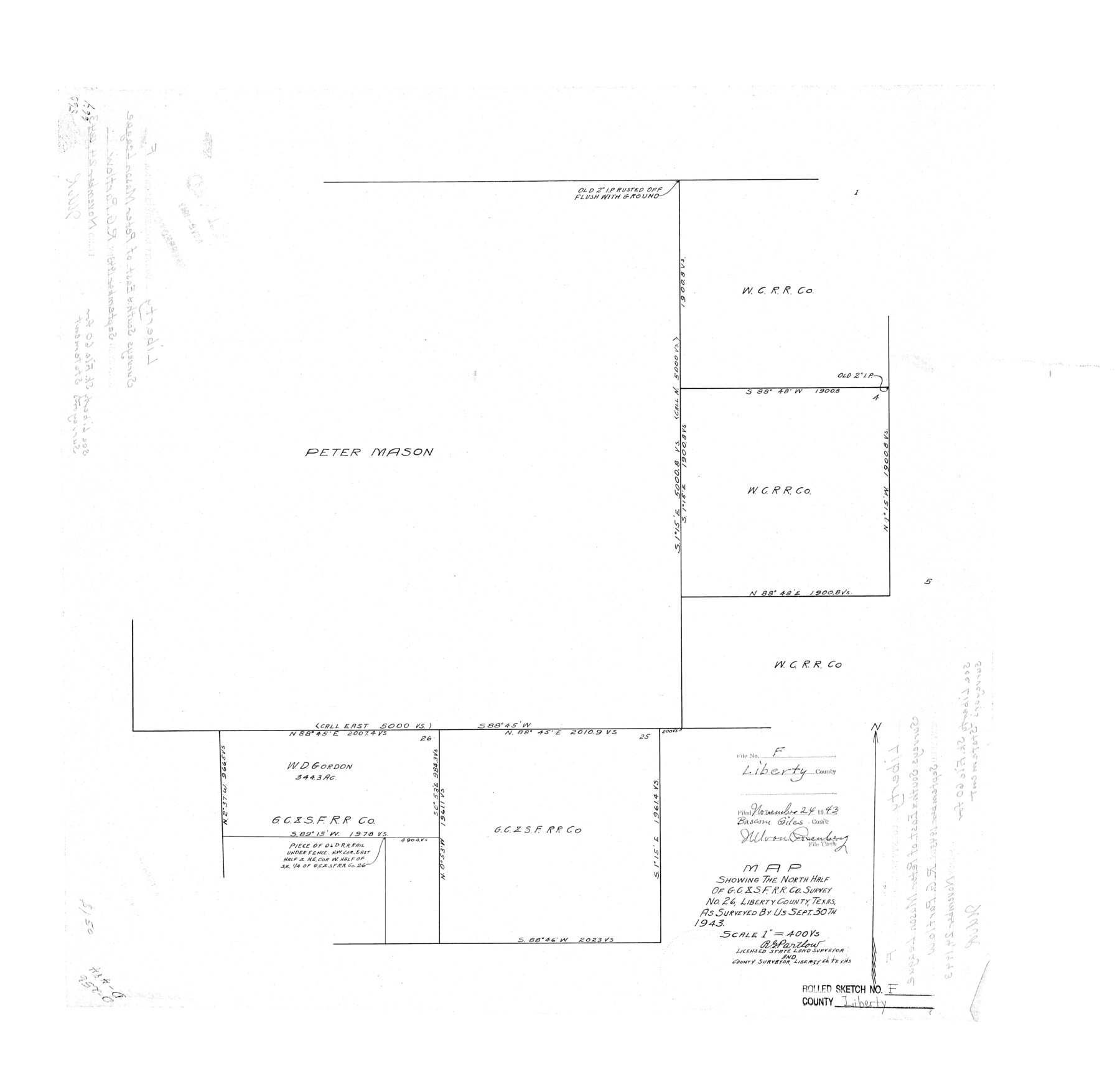
Liberty County Rolled Sketch F
Map showing the north half of G. C. & S. F. R.R. Co. survey no. 26, Liberty County, Texas
-
Map/Doc
6621
-
Collection
General Map Collection
-
Object Dates
1943/11/24 (File Date)
1943/9/30 (Survey Date)
-
People and Organizations
R.G. Partlow (Surveyor/Engineer)
-
Counties
Liberty
-
Subjects
Surveying Rolled Sketch
-
Height x Width
24.9 x 25.5 inches
63.2 x 64.8 cm
-
Scale
1" = 400 varas
Related maps
Liberty County Sketch File 60

Print $12.00
- Digital $50.00
Liberty County Sketch File 60
1943
Size 14.2 x 8.6 inches
Map/Doc 30071
Part of: General Map Collection
Parker County Working Sketch 22

Print $20.00
- Digital $50.00
Parker County Working Sketch 22
2007
Map/Doc 88607
Liberty County Working Sketch 45

Print $20.00
- Digital $50.00
Liberty County Working Sketch 45
1953
Size 28.9 x 39.8 inches
Map/Doc 70504
Menard County Sketch File 22

Print $8.00
- Digital $50.00
Menard County Sketch File 22
1927
Size 7.4 x 8.6 inches
Map/Doc 31553
Midland County Working Sketch 24

Print $40.00
- Digital $50.00
Midland County Working Sketch 24
1957
Size 42.9 x 80.9 inches
Map/Doc 71005
Reagan County Sketch File 16

Print $8.00
- Digital $50.00
Reagan County Sketch File 16
1932
Size 11.1 x 7.7 inches
Map/Doc 35002
Montgomery County Working Sketch 63

Print $20.00
- Digital $50.00
Montgomery County Working Sketch 63
1964
Size 31.6 x 36.7 inches
Map/Doc 71170
Uvalde County Sketch File 21

Print $8.00
- Digital $50.00
Uvalde County Sketch File 21
1882
Size 14.2 x 8.8 inches
Map/Doc 39004
Pecos County Sketch File 109

Print $5.00
- Digital $50.00
Pecos County Sketch File 109
1982
Size 14.8 x 9.3 inches
Map/Doc 34039
Cameron County Rolled Sketch US2

Print $168.00
- Digital $50.00
Cameron County Rolled Sketch US2
1913
Size 10.4 x 16.3 inches
Map/Doc 43804
Motley County Working Sketch 4

Print $20.00
- Digital $50.00
Motley County Working Sketch 4
1914
Size 19.9 x 10.2 inches
Map/Doc 71209
Hudspeth County Working Sketch 41

Print $20.00
- Digital $50.00
Hudspeth County Working Sketch 41
1981
Size 18.3 x 37.1 inches
Map/Doc 66326
Flight Mission No. CON-4R, Frame 143, Stonewall County

Print $20.00
- Digital $50.00
Flight Mission No. CON-4R, Frame 143, Stonewall County
1957
Size 18.3 x 22.0 inches
Map/Doc 86993
You may also like
Montgomery County Working Sketch 51

Print $20.00
- Digital $50.00
Montgomery County Working Sketch 51
1960
Size 38.7 x 40.4 inches
Map/Doc 71158
Fort Bend County Sketch File 33

Print $20.00
- Digital $50.00
Fort Bend County Sketch File 33
1889
Size 23.6 x 24.5 inches
Map/Doc 11513
Dickens County Sketch File N

Print $4.00
- Digital $50.00
Dickens County Sketch File N
1903
Size 8.3 x 13.6 inches
Map/Doc 20942
Dallam County Rolled Sketch 8

Print $20.00
- Digital $50.00
Dallam County Rolled Sketch 8
1949
Size 37.7 x 26.3 inches
Map/Doc 5686
Flight Mission No. DQN-5K, Frame 37, Calhoun County

Print $20.00
- Digital $50.00
Flight Mission No. DQN-5K, Frame 37, Calhoun County
1953
Size 18.5 x 22.1 inches
Map/Doc 84385
Right of Way and Track Map, The Missouri, Kansas and Texas Ry. of Texas operated by the Missouri, Kansas and Texas Ry. of Texas, Henrietta Division

Print $40.00
- Digital $50.00
Right of Way and Track Map, The Missouri, Kansas and Texas Ry. of Texas operated by the Missouri, Kansas and Texas Ry. of Texas, Henrietta Division
1918
Size 25.5 x 57.0 inches
Map/Doc 64071
Cottle County Sketch File 12

Print $20.00
- Digital $50.00
Cottle County Sketch File 12
1903
Size 18.7 x 16.6 inches
Map/Doc 11194
Right of Way and Track Map of The Wichita Falls & Southern Railroad Company

Print $40.00
- Digital $50.00
Right of Way and Track Map of The Wichita Falls & Southern Railroad Company
1942
Size 24.6 x 56.1 inches
Map/Doc 64516
Loving County Rolled Sketch 1B

Print $40.00
- Digital $50.00
Loving County Rolled Sketch 1B
1952
Size 42.7 x 77.7 inches
Map/Doc 9466
Denton County Sketch File 11

Print $4.00
- Digital $50.00
Denton County Sketch File 11
1856
Size 5.1 x 8.6 inches
Map/Doc 20709
Pecos County Sketch File 105

Print $4.00
- Digital $50.00
Pecos County Sketch File 105
1965
Size 14.3 x 8.8 inches
Map/Doc 34028
Wichita County Sketch File D

Print $22.00
- Digital $50.00
Wichita County Sketch File D
1919
Size 12.0 x 8.6 inches
Map/Doc 40061